Nennewitz

The Zeilendorf Nennewitz or Wüst-Nennewitz is a desolate village between Sachsendorf and Wermsdorf in the Wermsdorf Forest in Saxony .
Name forms
- 1161 Ninew (i) ze
- 1184 Nennewize
- 1459 Neniwitz the desert village
- 1533 teych at the churches in Nennewicz

description
Close to the old Poststrasse from Sachsendorf in the direction of Wermsdorf is the Mammbach wood in the Sachsendorf corridor. There in 1949 by the teacher and local researcher Fritz Lommatzsch a between 1350 and 750 BC. A burial ground with hill-like stone paintings and stone ceilings from the Early Bronze Age discovered at the Doktorteich . Between 800 and 900 a first arose in the neighborhood this cemetery Slavic settlement: Old Call joke exactly in place of today's church pond in which to the 11th century Slavic pitch boilers , beekeepers and pit Koehler their livelihood deserved. Around 1200 the surrounding forest was cleared and in the course of the second stage of the eastern settlement the German village Nennewitz with the castle, church and eight settlement houses for sixty to seventy settlers was created. The Romanesque church was dated to the year 1220 by archeology, it was she who later gave the pond its name and whose name was the cause of the later excavation. Between 1360 and 1380 Nennewitz was part of a desolate manor , which from this time on was again overgrown by the surrounding Wermsdorf Forest . In addition to Nennewitz, there are other devastations in the region with the same dating. Experts speculate about the causes, such as an inferiority of the sandy soil, a late medieval agricultural crisis or the plague could have been reasons for leaving the settlement, or several reasons at the same time, because the plague epidemics that raged in the 14th century In this region the villages were partially so depopulated that no one was left to do the nourishing work in the fields . Another theory says that the depopulation caused by the plague caused grain prices to fall, the rural population moved to the depopulated cities and no longer pursued the agricultural cultivation in this area, which was made difficult by the poor sandy soil. The establishment of the fish ponds under Dietrich von Starschedel made the last remains of the settlement disappear into the darkness of history over the centuries until the excavation under Gerhard Billig between 1971 and 1992. The ruins of the settlement houses sank in the church pond, their stones were used as building material for fortification walls and the establishment of the fish ponds, or transported away. Only their ovens and storerooms, which may have been away from the houses because of the risk of fire, can be seen by the trained eye when the water is low or the ponds are drained in the area of the shore zone.
Bronze Age burial ground
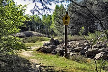
This is a Late Bronze Age cult and burial site of the Lausitz culture, laid out around 1250 to 750 BC . The total size is ninety by forty meters. There are three stone mounds on it, each eight and a half, fourteen and eleven meters in diameter. The cover consists largely of field stone . In the filling, which was built over a pit, articles of incendiary corpse and occasional shards were found. In the western part of the field there are nineteen shallow graves , some with several urns per grave, which are covered with a stone ceiling of eighteen by thirty-five meters. Due to the different layers of the stone ceiling on top of each other, it is likely that these were used as a burial site over a longer period of time or in several stages .
church
In 1220 the Romanesque hall church with a retracted choir and a rood screen was built. Since there are no records of church life, a relationship with Mutzschen can be assumed to be certain based on the documents , or even an organizational classification as a branch church of the Mutzschener Sprengel can be assumed. Furthermore, the remains of the altar plinth , as well as the more than thirty rubble stones of a monolithic baptismal font with surrounding ornaments were found, which was strangely deliberate and with great use of force and was not destroyed by environmental impact.
Castle
Around 1200, as part of the second stage of the German expansion to the east, a nobleman had a tower-hill castle with a square keep and round corners built on an artificially raised hill. The core plant was a mortar-stone fortification, modern for the time, and the outer plant was built in a traditional wood-earth construction. The surrounding moat was forty by thirty meters and up to six meters deep. The trench never carried water. The castle stands on a low ridge, which runs in a west-east direction in the north of the church pond in the west through the Wermsdorf forest . The interior of the castle essentially consists of a tower and a corner building. After 150 years of use, the facility was abandoned without any significant destruction.
tower
The central building of the castle was the tower or keep. The ascertained archaeological situation showed that the construction of the tower and the embankment took place at the same time. The ascertained corner rounding could have had a purely military function, since the round corners made of quarry stone could withstand the floors of the 13th century much more strongly or were easier to build from the locally found quarry stone material.
Corner building
Nothing is left of the rising masonry of the second stone building. The width of up to 98 centimeters measured in the foundation suggests that it must not have been a building with a defensive character . The corner location also speaks more in favor of living or kitchen use. During the entire excavation, no clear shaped stone was found, which indicates that all the building blocks were removed as building material. The ceramics found were wall fragments with simply painted surfaces and kneading traces and their profiles point to the time of the pre-blue-gray German settlement ceramics . The pottery of the pots of the Mutzschen Groschen find and the pottery found here are identical.
settlement
When the Kirchenteichdamm was no longer dammed in 1975, an excavation gave Prof. Gerhard Billig the opportunity to scientifically examine the high and late medieval village in front of and in the reed zone. Numerous theories about the previously unoccupied location of Nennewitz, or even the use of the castle remains as a late medieval fisherman's hut with protection from wild animals, supposed by "specialist colleagues", should be refuted. The excavation findings revealed a row arrangement of seven verifiable settlement houses, each of which had a stone oven (burning point) twenty to thirty meters away. The houses were built as half-timbered houses. The Slavic predecessor village Alt-Nennewitz , which was mentioned in a document in 1081, is located a hundred meters south of the excavation site and has only been confirmed by reading finds.
Storage
In the area of today's bank zone of the church pond, a store with the dimensions of four by four and a half meters was excavated, which was built as a timber frame. No evidence of barns or stables was found anywhere in the excavation site. There are also no findings on roof tiles, which suggests that all buildings were covered with reeds or straw.
Friedrich Gustav Klemm Society
The founder of the Friedrich - Gustav - Klemm - Gesellschaft, founded in 1990, which should actually be called Gustav - Friedrich - Klemm - Gesellschaft , is Prof. Dr. Gerhard Cheap from the Technical University of Dresden for Prehistory and Early History, who worked at the Karl Friedrich Wilhelm Wander University of Education until the fall of the Berlin Wall . In 1997, information boards were set up for the forest classroom, a log house with tables, benches and boards, and in 1998 an educational trail to the settlement, castle and church was set up with the support of the Chemnitz State Office for Museums. Once a year the society organizes a kind of summer camp in which nature is pushed back from the excavations, but new search cuts are also created. Under the supervision of the State Office for Archeology Dresden, the amateur archaeologists discovered new foundations in 2009, which may have supported the rectory.
literature
- Kurt Helbig, Wilfried Baumann: Notes on medieval pitch extraction in the Wermsdorfer Forest . In: excavations and finds. Volume 13 . Deutscher Akademieverlag der Wissenschaften, Berlin, 1968, p. 100 ff.
- Thomas Gerlich: The measurements of a medieval desert at the church pond in the Wermsdorfer Forest, Kr. Oschatz . In: excavations and finds. Volume 22 . Deutscher Akademieverlag der Wissenschaften, Berlin, 1977, pp. 33–35.
- Activity report of the State Museum for Prehistory . In: excavations and finds. Volume 24 . Deutscher Akademieverlag der Wissenschaften, Berlin 1979, pp. 4–6.
Web links
- Nennewitz in the Digital Historical Directory of Saxony
- ( Link ) Internet presence of the Friedrich-Gustav-Klemm-Gesellschaft, accessed on July 12, 2011.
Individual evidence
- ^ H. Kattner: local history in brief . In: Muldentalzeitung. Wurzen, November 14, 1997, p. 28.
- ↑ a b c Lisa Garn: The Trace of Stones: Archaeological Camp in the Wermsdorfer Forest Cultural Landscape Museum. Puzzles about discoveries at the church pond . Muldentaler Kreiszeitung. Grimma, July 17, 2009, p. 19.
- ↑ a b c d e Barbara Warning: Teachers and students reveal medieval village in the Wermsdorfer Forest for an open-air museum. History to touch and experience . In: Muldentalzeitung. Wurzen, August 2, 1999, p. 22.
- ↑ a b Frank Hörügel: Hobby archaeologists looking for sponsors to set up the cultural landscape museum at the church pond near Wermsdorf. The history of this Wermsdorf region. Klemm-Gesellschaft with finances in a tight spot . In: Oschatzer Allgemeine. Oschatz, August 30, 1997, p. 16.
- ^ Enno Bünz: Eastern settlement and regional development in Saxony: the Kührener deed of 1154 and its historical context . Leipziger Universitätsverlag, Leipzig, 2008, ISBN 978-3-86583-165-1 , p. 441.
- ^ Silke Kasten, Christian Schmidt: Wermsdorfer Wald cultural landscape museum soon to be complete. Invitation to travel back in time through early history . In: Leipziger Volkszeitung. Leipzig, August 14, 2000, p. 27.
- ↑ a b c d e Author collective: History in the forest. The cultural landscape museum in the Wermsdorf Forest . Volume 1. Writings of the Friedrich Gustav Klemm Society, Oschatz, 2004, ISSN 1613-625X .
- ↑ Madeleine Rau: The church pond near Fremdiswalde has been a point of attraction for members of the Klemmgesellschaft for years . In: Muldentalzeitung. Grimma, July 27, 2001, p. 27.
- ↑ a b Gerhard Billig: The stone buildings on the church pond ruins in the Wermsdorfer Wald. Part 1. The tower . In: Castle research from Saxony . Issue 18/1, Beier & Beran, Langenweißbach, 2004, ISBN 3-930036-95-9 , pp. 73 ff.
- ↑ a b Gerhard Billig: The stone buildings on the church pond ruins in the Wermsdorfer Wald. Part 2. The corner building . In: Castle research from Saxony . Issue 18/2, Beier & Beran, Langenweißbach, 2005, ISBN 3-937517-16-7 , p. 41 ff.
- ↑ hp: Professor Gerhard Billig turned 70. Secrets from ancient times revealed . In: Oschatzer Allgemeine. Oschatz, May 30, 1997, p. 13.
Coordinates: 51 ° 18 ′ 51.5 ″ N , 12 ° 53 ′ 48 ″ E


