Bessin

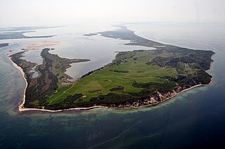
The Bessin is a double peninsula in the northeast of the island of Hiddensee . The peninsula is connected to the northeasternmost tip of Hiddensee.
It was created in the course of the last centuries by sediment erosion on the Dornbusch , which was deposited again on the lee side of the island of Hiddensee facing away from the current to the south. The headland Altbessin (also Alt-Bessin or Alter Bessin ) was formed as early as 1500, while the Neubessin was only formed from 1890. Long before the emergence of the New Bessin , the addition "Old" was common in the name of the Old Bessin ; the tip of the Bug peninsula on the opposite side of Rügen , which was still an island in the middle of the 19th century , was called New Bessin .
Both sand hooks are each a good three kilometers long and only a few hundred meters wide. They are only a few meters above sea level and consist of sand deposits, some with bushes, and very flat meadows along the banks. In front of them are some small uninhabited islands.
The Bessin is uninhabited and belongs to both a nature reserve and the Western Pomerania Lagoon Area National Park . Entering the breeding grounds of numerous sea and migratory birds is therefore generally not permitted.
topography

The Bessin can be divided into two areas:
- the Altbessin (also Alter Bessin , on older maps also Olbesin or Olden Besin ) is accessible to visitors on a path to the southern tip with an observation tower; there are gray dunes there .
- the Neubessin (also Neuer Bessin , Jungbessin or Nordosthaken ) belongs mostly to the core zone of the national park and is not allowed to be entered, however the northern part is excluded, on whose beach you can walk about 1.2 kilometers from the end thorn to a wooden fence. There are gray and white dunes .
While the Neubessin is densely overgrown with bushes, most of the land on the Altbessin was kept open by grazing (sheep, formerly also cattle). Several widely scattered old hawthorns with bald trunks remind of grazing . The Griebener Weide is also a reminder that cattle were driven from the Grieben across the shallow water of the Griebener Bay.
As a result, a valuable dry grassland has formed on the Altbessin, but it is increasingly being overgrown with roses and sea buckthorn . The origin of the Altbessins is less due to the formation of sand hooks than that of sand banks. These are already listed on a map from the 16th century and grew later with Hiddensee together, partly by sandy hook, partly by silting (Verschilfung). Some sandbanks can still be seen today, such as the largest, which is located directly southeast of Greaves. Here the former sandy area is covered with elements of dry grass and salt marshes , but the later silting areas with sedges and reeds.
Upstream of the southern tip of the Altbessins to the west is the Tedingsinsel , which is predominantly overgrown with sedges . This emerged around 1800. While the arm of the water separating the island is still relatively wide in the north, its width at the southern end of the Tedingsinsel has decreased to about 0.5 to 1 meter due to siltation. At the junction of the two Bessines, several beach lakes , which are now reeded, stretch from north to south . On a path between the entrance gate at Altbessin and the Neubessin beach, the area of the old Riegen and beach walls can be explored well.
The Neubessin has salt marshes and reed beds as well as bushes made of sea buckthorn, elder and sloe , but no dry grass because of the lack of grazing. To the northeast of the southern tip is a sand pit that is only partially covered with primary vegetation. Its origin lies in sand deposits parallel to the flow, only partially in sandbanks.
South of the Bessins a two kilometer-range includes windwatt with numerous small, sometimes sparsely vegetated islands, called Bessinsche Schaar . At low tide, like the Schaar south of the Gellens, it occasionally falls dry.
Coastal changes

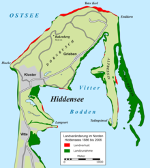
The growth of the Altbessins was only about one meter per year between 1830 and 1900; from 1960 onwards it did not grow at all, because at the time the New Canton moved in front of it from the north and made it impossible for sand to build up. Accordingly, even the east bank (i.e. the outer bank) of the Altbessins is covered by a reed belt today. The Neubessin grows southwards between 30 and 60 meters per year.
As can be seen on satellite images from 1989 and 1992, a sand hook stretched far south from what is now the southern tip of the New Rhine. With a later breakthrough and subsequent flushing of the hook to the southwest, an island formed. Another land extension to the south had formed north of the then Plathe-Sandhaken. By 2006, this sand hook had grown by 635 meters (that's around 45 meters per year). Then there was a breakthrough at the root that grew back together in 2007. There was another breakthrough at this sand hook at the end of 2008, this time further south. So there is now a sand hook part that has been reconnected to the Neubessin (which is still growing approx. 45 meters per year) and an island further south. This island has been migrating further south since then (but only about 20 meters per year).
Overall, the Bessin has grown, but in places that do not play a role in the north-south expansion. Rather, it has decreased in length since 1992 due to frequent breakthroughs, by 450 meters.
At the northeastern tip of Hiddensee, the Enddorn, an increasingly wider beach ledge was created from 1998. Another "Bessin" is expected to form here over the next few decades.
Buildings
At the southern tip of the Altbessins there is an approximately four-meter-high observation tower, from which you can see a large part of the sandbanks and sandhooks of the Neubessin. On the Neubessin (670 meters north of the southern tip) there is a small wooden hut that is inhabited by Vogelwart in the summer half-year. There are also several high seats on both peninsulas.
literature
- Günter Möbus: How Hiddensee became an island. Helms Verlag, Schwerin 2001, ISBN 3-93118587-7 .
- Karin Blase: Hiddensee A – Z. Demmler Verlag, Schwerin 2000, ISBN 3-910150-16-0 .
- Herbert Ewe : Hiddensee. VEB Hinstorff Verlag, Rostock 1983.
Web links
Individual evidence
- ↑ a b Friedrich von Hagenow, monograph of the Rügen chalk petrifications , in: New yearbook for mineralogy, geognosy, geology and petrefactuality , year 1840, E. Schweizerbart's Verlagshandlung, Stuttgart 1840, p. 635.
- ↑ Various issues of Meßtischblatt 1444, Kloster .
Coordinates: 54 ° 35 ' N , 13 ° 9' E
