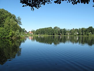
New Löcknitz (Grünheide)
The Neue Löcknitz in the community Grünheide (Mark) near Berlin is a tributary of the Spree tributary Löcknitz .
|
Löcknitz For inland shipping: Löcknitz Between Möllensee and Peetzsee: Rohrlake |
||
|
Möllensee near the Neue Löcknitz to the Peetzsee |
||
| Data | ||
| Water code | DE : 582786 | |
| location | Brandenburg , Germany | |
| River system | Elbe | |
| Drain over | Löcknitz → Spree → Havel → Elbe → North Sea | |
| source | Valley floor east of the Möllensee 52 ° 27 ′ 1 ″ N , 13 ° 52 ′ 27 ″ E |
|
| Source height | 35 m above sea level NHN | |
| muzzle | at the catch lock in the Löcknitz coordinates: 52 ° 25 '6 " N , 13 ° 47' 17" E 52 ° 25 '6 " N , 13 ° 47' 17" E |
|
| Mouth height | 32.4 m above sea level NHN | |
| Height difference | 2.6 m | |
| Bottom slope | 0.33 ‰ | |
| length | 8 kilometers | |
| Catchment area | 47.882 km² | |
| Left tributaries | Kiesseegraben | |
| Right tributaries | Rohrlake (only temporarily carrying water as an inflow) | |
| Flowing lakes | Möllensee , Peetzsee , Werlsee | |
| Communities | Grünheide (Mark) | |
course
The total of almost 8 km long water is located entirely in the municipality of Grünheide. It consists of a small inlet (381 m) in the east of the Möllensee and then from the chain of the southern Grünheider lakes, consisting of the aforementioned Möllensee, the Peetzsee and the Werlsee , including the canal connections between these lakes and from the Peetzsee to the Löcknitz. The section of the river from the confluence west of the Fangschleuse settlement to the Flakensee was rebuilt as the Löcknitz Canal at the beginning of the 20th century.
New Löcknitz (red brands) |
geology
As well as the valley of the (actual) Loecknitz are connected by the New Loecknitz lakes part of the Weichselian resulting Buckower channel .
use
After a weir had been built around 1700 to make rafting easier, in order to generate tidal waves if necessary, the chain of lakes was expanded into a shipping route in 1873–1875, the efficiency of which was further increased by the Löcknitz Canal mentioned above. Building materials for the growing nearby capital, wood, bricks and gravel were transported. An excursion steamer was also in use from 1882.
The Neue Löcknitz forms the largest part of the federal waterway Löcknitz (Lö) , which also only includes the straightened river section of the Löcknitz from the confluence to the Flakensee. There it has a connection to the federal waterway Rüdersdorfer Gewässer , which in turn consists of the lower parts of the Rüdersdorfer Mühlenfließ and the Löcknitz. Today the Rüdersdorfer waters are used almost exclusively by the sport boat trip, furthermore some passenger ships operate.
literature
- Eva Driescher: The Löcknitz and its catchment area - location, morphology, geo- and hydrogeology and hydrology of the river basin. (PDF; 4.4 MB) In: Water Ecology in Northern Germany. Volume 3, 1996, pp. 7-14.
- Eva Driescher: Settlement history and anthropogenic changes in the waters in the catchment area of the Löcknitz. (PDF; 4.5 MB) In: Water Ecology in Northern Germany. Issue 3, 1996.
- Jörg Gelbrecht, Gerhard Ziebarth: The NSG "Löcknitztal". (PDF; 104 kB) Leibniz Institute for Freshwater Ecology and Inland Fisheries, Interest Group Löcknitztal e. V., without dating.
Individual evidence
- ↑ Page no longer available , search in web archives: BB-Viewer, DTK10: Möllensee and the valley floor to the east
- ↑ http://www.stadtentwicklung.berlin.de/umwelt/wasser/wasserrecht/pdf/wasseratlas4.pdf
- ↑ a b State Office for the Environment, Health and Consumer Protection (LUGV), Brandenburg: List of waters. (River), Version 4.1., As of July 14, 2015. p. 31.
- ^ WSA Berlin: Löcknitz (Lö)

