
Buckower gutter
 | |||
Light green marks at both ends and light blue in the apex of the Buckower gutter |
The Buckower Rinne , also Löcknitz / Stöbber-Rinne , between the Oderbruch and the Spree just east of Berlin is one of the glacial meltwater channels of very different origins, which developed in the last two phases of the Vistula Ice Age between the dead ice- filled Oderbruch and the Berliner Urstromtal (today's Spreetal) formed. Others are the Gamengrund further to the west and less deep, such as the Platkow-Kersdorfer Rinne, further east. The Buckower Rinne as the widest separates the Barnimplatte from the Lebuser Platte .
Today's waters
In the wetland called Rotes Luch in the apex area of the channel there is a pseudobifurcation from which the Stöbber flows northeast to the Alte Oder , the Stöbberbach flows southwest to the Löcknitz , which in the Dämeritzsee , a few kilometers east of the Berlin city limits, flows into the Spree and thus to the river system belongs to the Elbe .
Emergence
As a small glacial valley, this channel drained meltwater from the Mohriner Sander of the Pomeranian ice edge to the southwest over a seal made of dead ice that filled the Oderbruch, across to the Berlin glacial valley. After the large ice cap over today's Baltic Sea had melted so far that the meltwater could flow from its edge through the Randow Urstromtal, a counter-rotating blade formed on the slope above the Oderbruch . However, this by no means resulted in the - potentially possible - tapping of the Spree in Berlin's glacial valley, because the deepening so far only extends as far as Waldsieversdorf . The watershed is 46.3 m above sea level. NHN today more than 10 meters above the Spree (35.1 meters above sea level. NHN at Mönchwinkel and 32.7 m above sea level. NHN in Dämeritzsee ).
The melt water from the dead ice masses of the Buckower Kessel now flowed to the northeast and shaped today's Stobbertal, which is deeply washed out between the heights of the terminal moraines . Dead ice blocks created depressions with no drainage on the surface, in which lakes like the Schermützelsee formed. The original box valley shape and direction of flow of the Buckower Gully is only preserved to the west of the apex area, which is also known as the Buckower Gate .

Märkische Schweiz on the northeastern part

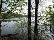
Schermützelsee in Mark Switzerland

Red lynx in the crown area
Liebenberger See in the southwestern part


tourism
A particularly impressive landscape relief with valley incisions and hollows filled with lakes has emerged northeast of the apex area. It is known as the Märkische Schweiz .
literature
- Gerd W. Lutze, Natural Areas and Landscapes in Brandenburg and Berlin: Structure, Genesis and Use , be.bra-verlag, June 2014, ISBN 978-3-95410-030-9
supporting documents
- ^ Dierk Heerwagen: Out and about in the Märkische Schweiz Nature Park. .... P. 7.
- ↑ Page no longer available , search in web archives: BB-Viewer: DTK50, water level in the apex area of the pseudobifurcation Stöbber / Stöbberbach
- ↑ Claus Dalchow, Joachim Kiesel: The Oder reaches into the Elbe area - tension and predetermined breaking points between two river areas. (PDF; 2.9 MB). In: State Office for Mining, Geology and Raw Materials Brandenburg (Ed.): Brandenburg Geoscientific Contributions. Issue 1/2. Kleinmachnow 2005, p. 81, ISSN 0947-1995 .
- ^ LAG Märkische Schweiz e. V .: Natural area Märkische Schweiz.