
Origin (Leinburg)
| origin | ||
|---|---|---|
 Valley with the stream of the same name |
||
| location | District of Nürnberger Land , Bavaria | |
| Waters | origin | |
| Mountains | Franconian Alb | |
| Geographical location | 49 ° 26 '3 " N , 11 ° 17' 46" E | |
|
||
| Type | Kerbtal | |
| rock | Drift sand | |

The origin is a valley and a stream of the same name near Leinburg in the district of Nürnberger Land in Bavaria .
description

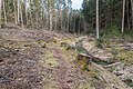
A section of the valley in 2013
A valley section in 2020


Origin, or also known as the Ursprung Valley, is a naturally formed valley in the Nuremberg Reichswald . The stream of the same name, Ursprung, flows through part of the valley . The approximately 3.5 kilometers long valley is located about two kilometers south of Leinburg and is entirely within the municipality. Most of the valley is part of the lichen-pine forest nature reserve south of Leinburg . It borders on the unincorporated area of Leinburg to the north and the unincorporated area of Brunn to the south . The section above the former upper mill is completely fenced, inaccessible and part of the Nuremberg water supply .
In the lower section of the narrowly notched valley flows the Ursprung, which drains south of Fuchsmühle into the Haidelbach . In addition, it is fed by a few small, nameless brooks that arise in the surrounding area or serve to drain off surface water . The valley, which used to look wild and romantic, was forested on the flanks until 2017. After a bark beetle infestation caused by clearing it appears today (2020) not very attractive.
The valley is one of three local glacial valley gullies that cut into the watertight Keuper . The three channels are covered with drifting sand dunes up to 60 meters thick and were created in the Pleistocene . In one of these gullies a valley gully up to 25 meters deep has notched itself.
The original source of the origin emerged in a funnel-shaped washed-out cauldron. The discharge from the outlet source averaged 95 liters per second in front of the socket. The impermeable layer under the sand consists of fire flies . It prevents rainwater from seeping in and feeds the spring outlet. The drifting sand was washed away and the valley was notched.
After the completion of a water extraction system around 1893, the water extracted from the origin was directed to an elevated tank at the Schmausenbuck in Nuremberg . Today around 15,000 cubic meters of drinking water are extracted daily from a total of 45 wells from a depth of up to 148 meters.
Speckweiher
In the lower part of the valley there have been two ponds again since the 1980s , which are also incorrectly known locally as Krämersweiher. The ponds were entered on maps as bacon ponds until they dried up in the 1950s. The Speckweiher used to serve as a mill pond for the abandoned Roesmühle . In the 1980s, the origin, which is only fed artificially and temporarily by the waterworks, was dammed there again. The water that is fed in is temporarily taken from the drinking water system and discharged into the origin at the level of the former upper mill. However, the ponds are now nameless on the relevant maps.
Up until the end of the 19th century there were two water mills on the course of the stream . With the purchase of the Roes and Obermühle, which are now lost, the city of Nuremberg has become the owner of the entire valley of origin from the eastern headwaters to the Krämersweiher estate .

Roesmühle

The Roesmühle is an old mill . It was about two kilometers southeast of Leinburg on the lower reaches of the origin. Belonging to the mill were two mill ponds, the Speckweiher.
The mill was demolished in 1901 and today only a monument in the form of a millstone with a bronze plaque reminds of this former property.
The inscription reads:
- The Roesmühle stood here. Bought by the municipality of Nuremberg i. J. 1900, laid down in 1901
The Roesmühle was owned by Johann Georg Bub around 1830 and was sold to the city of Nuremberg on January 27, 1900, together with the Speckweihern. The purchase price for the 55.47 days (about 19 hectares) property was 27,000 marks.
Due to the construction of the water extraction systems (from 1893) by the city of Nuremberg in the Ursprung / Krämersweiher area, the Obermühle and Roesmühle lost a lot of water. Ultimately, the city of Nuremberg bought the two mills, shut them down and broke them down. The valley and the neighboring property Krämersweiher am Haidelbach, together with the original water supply, became part of the Nuremberg water supply.
The descendants of the former mill owners are now the owners of the Leinburger private brewery Bub (Leinburger beer).
Obermühle

The upper mill is an old mill. It was about 2.2 kilometers south of Leinburg at the origin. There were two mill ponds belonging to the mill, which are now lost. The Obermühle came about in 1833 through the marriage of Kunigunde Bachmeier and Johann Bub jun. in the possession of the Bub family. The property was sold to the city of Nuremberg around 1895 and subsequently demolished. Today only a monument in the form of a millstone with a bronze plaque reminds of this former mill estate.
The inscription reads:
- This is where the Obermühle stood, bought by the municipality of Nuremberg in 1895, closed down from 1895 to 1898
Individual evidence
- ↑ Origin in: BayernAtlas , accessed on May 7, 2020.
- ↑ The community of Leinburg at a glance (PDF document, page 7), in: Community of Leinburg , accessed on May 7, 2020.
- ↑ Geological map in: BayernAtlas , accessed on May 7, 2020.
- ↑ Time travel 1954 in: BayernAtlas , accessed on May 7, 2020.
- ↑ 125 years of the Krämersweiher waterworks (PDF document, page 11/12), in: Ulrich Mohr's homepage , accessed on May 7, 2020.
- ↑ Location of the Roesmühle, first recording (1808-1864) in: BayernAtlas , accessed on May 7, 2020.
- ↑ Location of the Obermühle, first recording (1808-1864) in: BayernAtlas , accessed on May 7, 2020.