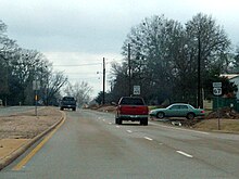
Omaha (Texas)
| Omaha | ||
|---|---|---|
|
Location of Omaha in Texas
|
||
| Basic data | ||
| State : | United States | |
| State : | Texas | |
| County : | Morris County | |
| Coordinates : | 33 ° 11 ′ N , 94 ° 45 ′ W | |
| Time zone : | Central ( UTC − 6 / −5 ) | |
| Residents : | 1,021 (as of 2010) | |
| Population density : | 340.3 inhabitants per km 2 | |
| Area : | 3.0 km 2 (approx. 1 mi 2 ) of which 3.0 km 2 (approx. 1 mi 2 ) are land |
|
| Height : | 122 m | |
| Postal code : | 75571 | |
| Area code : | +1 903 | |
| FIPS : | 48-54024 | |
| GNIS ID : | 1357296 | |
Omaha is a city in Morris County in the state of Texas in the United States .
Omaha is part of the Ark-La-Tex socio-economic region , which includes parts of the four states of Arkansas , Louisiana , Oklahoma, and Texas.
geography
Omaha is located in the northeast of the state of Texas in the southern United States. It is in the midst of a lake landscape that stretches from northeast Oklahoma to east Texas. It is located about midway between the three great lakes Wright Patman Lake , Lake O'the Pines and Lake Bob Sandlin .
Nearby cities include Naples (two miles northeast), Cookville (seven miles west), Daingerfield (twelve miles south), and Mount Pleasant (15 miles west).
history
Omaha was founded as Morristown by Thompson Morris in 1880 , but the post office was called Gavett . In 1886 six men from Randolph County , Alabama, decided by drawing lots for the new name that is still valid today.
Because of its central location and the connection to the St. Louis Southwestern Railway , the city grew rapidly. As early as 1890 it had three churches, a school, a weekly newspaper and around 450 residents. In the 20th century, Omaha was a transshipment point for vegetable freight.
traffic

Omaha is traversed west to east by US Highway 67 , which runs from southwest Texas to Iowa . In the east of the city it crosses US Highway 259 , which connects Omaha with Heavener in the north and Nacogdoches in the south.
Interstate 30 runs just under 14 kilometers north of the city .
Greater Morris County Airport is about 3.5 kilometers southeast of the city .
Demographics
The 2000 census showed a population of 999 people, divided into 389 households and 264 families. The population density was 330 people per square kilometer. 77% of the population were white, 20% black, 0.5% Pacific islanders, 0.2% Asian and 0.1% Indian. 1.4% were of a different ethnicity , 0.8% had two or more ethnicities, and 3.6% were Hispanic or Latin American of any ethnicity. For every 100 women there were 76 men. The median age was 41 years and the per capita income was 14,750 US dollars, putting about 24.5% of the population below the poverty line.
At the 2010 census , the population rose to 1,021.
Web links
- Statistical data to Omaha (Engl.)
- Omaha in Handbook of Texas (Engl.)
