
Oporez
| Oporez | |||
| Опорець | |||

|
|
||
| Basic data | |||
|---|---|---|---|
| Oblast : | Lviv Oblast | ||
| Rajon : | Skole district | ||
| Height : | 706 m | ||
| Area : | 22.91 km² | ||
| Residents : | 1,035 (2001) | ||
| Population density : | 45 inhabitants per km² | ||
| Postcodes : | 82652 | ||
| Area code : | +380 3251 | ||
| Geographic location : | 48 ° 47 ' N , 23 ° 20' E | ||
| KOATUU : | 4624584901 | ||
| Administrative structure : | 1 village | ||
| Address: | 82652 с. Опорець | ||
| Website : | City council website | ||
| Statistical information | |||
|
|||


Oporez ( Ukrainian Опорець ; Russian Опорец , Polish Oporzec ) is a village in the south of the Ukrainian Lviv Oblast with about 1000 inhabitants (2001).
The village, first mentioned in writing in 1490, is the only place in the 22.91 km² district council of the same name in the south of Skole Rajon on the border with the Transcarpathian Oblast .
The village is located in the Forest Carpathians on the upper reaches of the Opir , northeast of the Wolowez Pass at an altitude of 706 m . It is located 40 km southwest of the Skole district center and 147 km southwest of the Lviv oblast center .
The Lviv – Stryj – Chop railway runs through Oporez and connects the village with Skotarske in the Transcarpathian Oblast via the Beskyd tunnel .

Church of the Assumption in Oporez
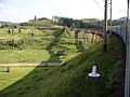
Railway line at Oporez

View over Bychkowa (Бичкова) to the south of Oporez

Field hospital in Oporez in April 1915


.jpg)
Web links
- Oporzec . In: Filip Sulimierski, Władysław Walewski (eds.): Słownik geograficzny Królestwa Polskiego i innych krajów słowiańskich . tape 7 : Netrebka – Perepiat . Walewskiego, Warsaw 1886, p. 566 (Polish, edu.pl ).
Individual evidence
- ↑ Local website on the official website of the Verkhovna Rada ; accessed on September 23, 2019 (Ukrainian)
- ↑ history Oporez in the history of the towns and villages of the Ukrainian SSR ; accessed on September 23, 2019 (Ukrainian)
- ^ Website of the district council on the official website of the Verkhovna Rada; accessed on September 23, 2019 (Ukrainian)