Papakura
| Papakura | ||
| Geographical location | ||
|
|
||
| Coordinates | 37 ° 4 ′ S , 174 ° 57 ′ E | |
| Region ISO | NZ-AUK | |
| Country |
|
|
| region | Auckland | |
| District | Auckland Council | |
| Ward | Manurewa-Papakura Ward | |
| Residents | 45 636 (2013) | |
| height | 18 m | |
| Post Code | 2102-2105, 2110, 2112, 2113 | |
| Telephone code | +64 (0) 9 | |
| UN / LOCODE | NZ PP8 | |
| Photography of the place | ||
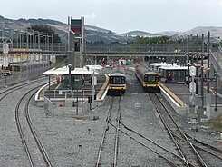
 Part of the Papakura train station |
||
| Remarks | ||
| until October 2010 part of the Papakura District | ||
Papakura is a former independent city in the urban area of today's Auckland Council on the North Island of New Zealand . Until the end of October 2010 it was the administrative seat of the Papakura District , which wasincorporatedinto the newly formed Auckland Council on November 1, 2010.
Origin of name
The name of the city means something like "Red Plain" in the Māori language , which was due to the fertile soil. The name originated from the combination of " papa " for level and " kura " for the color red.
geography
The city center of Papakura is located around 29 km south-southeast of the city center of Auckland and around 15 km north-northeast of Pukekohe , at the eastern end of the Pahurehure Inlet of Manukau Harbor , a natural harbor that extends westward from here.
There are no major rivers in and around the city, so drinking water must be obtained from the rainforest areas of the Hunua Ranges , a good 13 km east of the city. There is or was fertile farmland between the mountains and the natural harbor. In the meantime, the district, which formerly only lived from agriculture, is increasingly shaped by the urban sprawl of the Auckland region spreading to the south .
history
In 1939, a military camp was built near the city, which served an important function within the New Zealand Army until its closure from 1992 to 2002 .
population
In the 2013 census, the urban area combined to form the Papakura Local Board Area had 45,636 inhabitants, 9.8% more than in the 2006 census.
Infrastructure
Road traffic
To the west of the city, the Auckland- Hamilton Highway , which is also part of the New Zealand State Highway 1 , which runs from north to south, runs past and thus connects the city directly with the city of Auckland .
Rail transport
Coming from Pukekohe , the North Island Main Trunk Railway runs directly through the city and has an important stopping point with the train station in the middle of the city, via which the S-Bahn- like local passenger transport is handled.
Personalities
- Kareen Fleur Adcock (* 1934), British-New Zealand poet and translator
- Kieran Read (born 1985), rugby player
literature
- Helga Neubauer: Papakura . In: The New Zealand Book . 1st edition. NZ Visitor Publications , Nelson 2003, ISBN 1-877339-00-8 , pp. 213 f .
Individual evidence
- ↑ a b 2013 Census QuickStats about a place : Papakura Local Board Area . Statistics New Zealand , accessed September 20, 2017 .
- ^ Neubauer: Papakura . In: The New Zealand Book . 2003, p. 213 .
- ↑ a b c Topo250 maps . Land Information New Zealand , accessed September 20, 2017 .
- ^ Margaret McClure : Auckland places - Papakura and the rural south-east . In: Te Ara - the Encyclopedia of New Zealand . Ministry for Culture & Heritage , December 6, 2007, accessed September 20, 2017 .
