Pau (Aachen)
| Paubach | ||
|
Paubach on Kaiser-Friedrich-Allee |
||
| Data | ||
| Water code | DE : 282818 | |
| location | North Rhine-Westphalia , Germany | |
| River system | Rhine | |
| Drain over | Wurm → Rur → Maas → Hollands Diep → North Sea | |
| River basin district | Meuse | |
| source | In the Aachen city forest on Ronheider Berg 50 ° 45 ′ 6 ″ N , 6 ° 4 ′ 17 ″ E |
|
| Source height | approx. 216 m above sea level NN | |
| muzzle | In Aachen at Rehmplatz in the Wurm coordinates: 50 ° 46 '38 " N , 6 ° 5' 54" E 50 ° 46 '38 " N , 6 ° 5' 54" E |
|
| Mouth height | approx. 156 m above sea level NN | |
| Height difference | approx. 60 m | |
| Bottom slope | approx. 14 ‰ | |
| length | 4.2 km | |
| Catchment area | 9.927 km² | |
The Pau is one of the Aachen brooks that flow through the historic old town of Aachen . It belongs to the Wurm brook system , which drains the Aachen valley basin.
origin
The Pau rises as Paubach in the Aachen city forest on the Ronheider Berg and flows from there towards Hangeweiher . On Kaiser-Friedrich-Allee, it feeds the Triton Fountain created by Carl Burger from 1906 to 1907 .
history

As early as Roman times, the Pau above the hanging pond was derived from its natural course in order to have cold water for the thermal baths that were located near the thermal springs in what is now Aachen's city center.
In the Middle Ages, this artificial stream was primarily used to supply the city of Aachen with drinking and industrial water and to drive mills. Only a small amount of water remained in the original stream bed and formed the stream Paunell (little Pau).
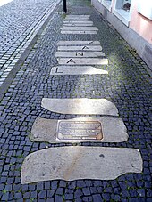
The canalized Pau ran in stone channels made of Aachen bluestone , which were partly open, but were increasingly covered with stone slabs. Such sandstone slabs were 2005 u. a. Discovered during excavation work in the racetrack, where they are now visible integrated into the paving of the sidewalk . Part of a bluestone channel in the Pau Canal can be seen in the archaeological window on the corner of Jakobstrasse and Klappergasse .
During the siege of Aachen in 1248 , when the outer city wall had not yet begun, Wilhelm von Holland had Johannisbach, Pau and Paunell dammed and thereby flooded a large part of the city area to force Aachen to give up.
Historical course
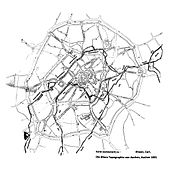
The medieval artificial brook course of the Pau originated near the Colynshof and passed above the Hangeweiher. There she drove the Lohmühle, which stood roughly on the site of today's public observatory , and the burned mill near today's Hohenstaufenallee. From there the course led along the ridge, which extends from the southwest to the market square. The Pau flowed along Weberstraße to the outer city wall, which it flowed through near Rostor . At the Rostor there was a walled basin that was filled by the Pau and from which lead pipes led off to supply public fountains ( Laufbrunnen , called “Pief” in Aachen) and various town houses with water.
From the Rostor the course led to the Rosmühle, which was driven by the Pau, and further along Stromgasse and Paugasse to the inner city wall, which it flowed through between the Jakobsmittelor and the tower to the east of it. From there the Pau flowed along Jakobstrasse to Klappergasse. Then we went along Klappergasse, Rennweg and Schmiedstraße to Marschierstraße. In the Klappergasse, where the Pau had its greatest gradient, stood the Brudermühle, which was driven by the Pauwasser, on Elisabethstrasse, which was then called Heppionsgasse, and another mill, the Heppionsmühle.
The brook was divided up in the Marschierstrasse. One part ran to the Marschiermittelor, a gate of the inner city wall, and was used there to fill the moat. This part of the Pauwasser flowed out of the city moat at the Ursulinertor along Adalbertstrasse and merged there with the Paunell. The other part of the Pauwassers flowed first along Elisabethstrasse for a part, then towards the city wall. The canal crossed the moat in a stone channel between Marschiermittelor and Harduinstor and the Paunell in Wirichsbongardstraße. In the vicinity of Kaiserplatz, the Pau merged with the Johannisbach , which in the meantime had also absorbed the water of the Paunell. North of Kaiserplatz, the three combined brooks left the medieval city through the water tower and shortly afterwards flowed into the Wurm.
Today's course
Today the Pau no longer has a separate course from the Paunell, but is guided underground through the city from the hanging pond. The canal follows the course Goethestrasse, Mozartstrasse, Karmeliterstrasse, Franzstrasse, Kapuzinergraben, Friedrich-Wilhelm-Platz, Peterstrasse. Pau / Paunell merge with the Johannisbach under Peterstraße, only to flow into the Wurm shortly afterwards. The worm reappears at Europaplatz.
literature
- Carl Rhoen : The older topography of Aachen . Verlag der Cremersche Buchhandlung, Aachen 1891. (Online version, pdf part 1, 2.84 MB , part 2 with map, 2.61 MB )
- Walter Holtzhausen, Jochen Richard a. a .: Südstraße and the Reumont district . 7th edition. Aachen 2007 ( Online [PDF; 2.9 MB ]).
- Ecology Center Aachen (ed.): Explore brooks in Aachen . Aachen 2000, p. 75 .
- Christof Peter, Franz Meiers and others: Securing evidence - walks along the Aachen brooks . Library of the Burtscheid Society for History and Present eV , Aachen 1983, page 52 ff. (“Die Pau”).
Web links
- The Johannisbach. (with a map that also shows the historical and current course of the Pau) In: The Aachen brooks. Ecology Center Aachen eV, accessed on May 10, 2009 .
- Historical Pau exposed again , in Aachener Nachrichten on January 28, 2009


