
Peitlerkofel
| Peitlerkofel - Sass de Pütia - Sass de Putia | ||
|---|---|---|
 |
||
| height | 2875 m slm | |
| location | South Tyrol , Italy | |
| Mountains | Dolomites | |
| Dominance | 5.9 km → Wasserkofel | |
| Notch height | 638 m ↓ southwest of Kreuzjoch | |
| Coordinates | 46 ° 39 '32 " N , 11 ° 49' 14" E | |
|
||
| Normal way | over Würzjoch and Peitlerscharte | |

The Peitlerkofel ( Ladin Sass de Pütia , Italian Sass de Putia ) is at 2875 m the highest mountain in the Peitlerkofel group in the Dolomites in South Tyrol , Italy . It is located in the municipality of St. Martin in Thurn and the Puez-Geisler Nature Park .
Because of its peripheral location in the Dolomites and the steep north slopes, the Peitlerkofel is known as the north-western cornerstone of the Dolomites.
The 2,813 meter high western secondary peak is known as the Kleiner Peitler .
The hike to the summit requires from the col between Peitler's Small and Peitlerkofel on some climbing sections ( Level I ) surefootedness and head for heights . Safety ropes are installed here. The Kleine Peitler can be hiked.
A possible starting point is the Zanser Alm (1,689 m) near St. Magdalena in Villnöß . The ascent takes place via Gampenalm (2062 m), Schlüterhütte (2301 m) and Peitlerscharte (2357 m). You can also climb the Peitlerscharte from the Würzjoch or from Campill (Lad. Longiarü) in St. Martin in Thurn.
Near the Würzjoch, west of the Peitlerkofel, are the Alpe Fornella and the Ütia de Göma, where you can stop. There is also a snack station on the eastern side (towards Campill) , the Ütia Vaciara. A hiking trail leads around the Peitlerkofel.
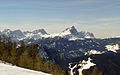
View from the Furkelpass

Summit of the Peitlerkofel from the Kleiner Peitler
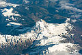
Aerial view


literature
- Heinrich Forer: Two hypotheses for name explanations: Peitlerkofel, Alfass . In: Der Schlern , 66, 1992, p. 469.
- Michael Jesacher: Stratigraphic and tectonic development of the Peitlerkofel area (Sas de Pütia) on the northern edge of the Dolomites . Diploma thesis, Innsbruck 1999.
- Josef Thomaser: The vegetation of the Peitlerkofel in South Tyrol . In: Publications of the Tiroler Landesmuseum Ferdinandeum , 47, 1967, pp. 67–119.
Web links
Individual evidence
- ↑ Luis Trenker / Helmut Dumler: The most beautiful high-altitude trails in the Dolomites. Munich 1978, p. 65.