Pelagonia
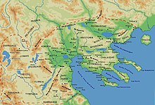
Pelagonia ( Greek Πελαγονἱα Pelagonia , Macedonian Пелагонија Pelagonija ; Albanian Pellgania / Pellgazia ; Bulgarian Пелагония ) is a region on the Balkan Peninsula . Today it lies in the south of the Republic of North Macedonia and in the north of Greece and is crossed by the upper reaches of the Crna Reka , a western tributary of the Vardars . The landscape includes the North Macedonian cities of Prilep and Bitola and the Greek city of Florina . In Pelagonia there is also the second most important border crossing between North Macedonia and Greece between the places Medžitlija and Niki.
history
The name Pelagonia could etymologically be related to the Albanian word pellgu 'pond', which in turn is borrowed from ancient Greek πέλαγος pelagos , German 'sea' . The inhabitants of the landscape were called 'Pelagonians' (Greek Πελαγόνες Pelagones ).
The ancient landscape lay between Illyria in the north and west, Peonies in the east and the Lynkestis in the south. Strabo refers to Pelagonia as tripolitis, after three main cities in the region, one of which is presumably also called Pelagonia. The Macedonian King Philip II incorporated Pelagonia into the territory of Macedonia , whose history it has shared since then.
Around 680 the Bulgarian prince Kuwer moved south from Pannonia , together with parts of the Sermesianoi and the 626 Roman prisoners who had been abducted by the Avars, after a failed revolt against the Avars. After an unsuccessful siege of Thessaloniki (682–684), he signed a treaty with the Byzantine emperor Constantine IV. Pogonatos and settled in the unpopulated area of Bitola (today's Pelagonia), which was part of the Byzantine theme of Thessalonica . Kuver established a khaganate there in 680, which was also called Bulgaria. However, the designation of this empire as the West Bulgarian Empire is controversial.
Pelagonia was the scene of the Battle of Pelagonia in September 1259 , in which Byzantines and Franks fought for supremacy in Greece.
Use of the name
Pelagonia is now the name of one of the eight statistical regions of North Macedonia . It includes the municipalities of Bitola , Demir Hisar , Dolneni , Krivogaštani , Kruševo , Mogila , Novaci , Prilep and Resen . One of the seven dioceses of the Macedonian Orthodox Church corresponds to the statistical region and is called Prespa and Pelagonia .
The Pelagonian Zone is named after Pelagonia , a geological area that runs through the Balkan Peninsula from Pelagonia in a south-south-east direction to Euboea, Boeotia and the Argolis.
Individual evidence
- ↑ Thede Kahl, Izer Maksuti, Albert Ramaj: The Albanians in the Republic of Macedonia . Facts, analyzes, opinions on interethnic coexistence. In: Viennese Eastern European Studies . tape 23 . Lit Verlag, 2006, ISBN 3-7000-0584-9 , ISSN 0946-7246 , The Albanian Continuity of Pre-Roman Place Names in Today's Macedonia, p. 14 .
- ↑ Vladimir Ė Orel: A Concise Historical Grammar of the Albanian Language: Reconstruction of Proto-Albanian . Brill, Leiden 2000, ISBN 978-90-04-11647-4 , p. 264 ( books.google.de )
- ^ William Smith: Dictionary of Greek and Roman Geography . London 1854 ( tufts.edu )
- ↑ Strabo: Geography 7.7.9 ( tufts.edu )
- ↑ Archaeological report on excavations in Macedonia ( Memento of April 10, 2008 in the Internet Archive ) (English)
- ↑ Lexicon of the Middle Ages . Volume V. Artemis Verlag, Munich 1991, ISBN 3-7608-8905-0 , Sp. 1558
- ↑ Acta Sancti Demetrii (in: Гръцки извори за българската история)
- ^ Raymond Detrez: Historical dictionary of Bulgaria . Scarecrow Pr., 1997, ISBN 0-8108-3177-5 , p. 267
- ↑ Zlatarski believed that they should have settled around 687 west of the Struma River .
- ↑ Entry on the Pelagonian Zone at geoscienceworld.org (English)
- ↑ Birte Anders: The Pre-Alpine Evolution of the Basement of the Pelagonian Zone and the Vardar Zone, Greece . (Diss.) Mainz 2005
Coordinates: 41 ° 0 ' N , 21 ° 21' E
