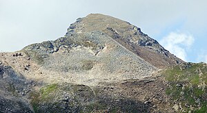
Pflerscher Pinggl
| Pflerscher Pinggl | ||
|---|---|---|
|
Pflerscher Pinggl from the northeast |
||
| height | 2767 m above sea level A. | |
| location | Tyrol / South Tyrol | |
| Mountains | Stubai Alps | |
| Dominance | 0.64 km → Hoher Zahn | |
| Notch height | 67 m ↓ notch to the Hohe Zahn | |
| Coordinates | 46 ° 59 ′ 27 ″ N , 11 ° 19 ′ 0 ″ E | |
|
|
||
| Type | Rock peaks | |
| rock | Paragneiss | |
| Age of the rock | 343-331 millions of years (Thöni 1993) | |
The Pflerscher Pinggl is 2767 m above sea level. A. high mountain in the Stubai Alps on the border between Austria and Italy .
Location and surroundings
The Pflerscher Pinggl is part of the main Alpine ridge , which separates the Tyrolean Gschnitztal in the north from the South Tyrolean Pflerschtal in the south. The neighboring mountain to the west is the Hohe Zahn and the 3,017 m high Weisswandspitze , to the northeast the ridge continues to the 2599 m high Pflerscher Scharte .
South of the Pflerscher Pinggl lies the Sandessee with the Italian Tribulaunhütte ( 2369 m ), which is the starting point for the ascent of the mountain.
geology
The Pflerscher Pinggl consists mainly of paragneiss , the typical rock of the Ötztal-Stubai crystalline .

ways
There is no marked path to the summit. The Pflerscher Pinggl can be climbed via the south-west or east ridge, both climbs have difficulty level I (UIAA) .
Individual evidence
- ^ Egon Bernabè: Petrological and thermobarometric investigations on the Pflersch metabasite complex (Pflerschtal, South Tyrol - Italy) . Innsbruck, Univ., Diploma thesis, 2009, 125 pages
- ^ Heinrich and Walter Klier : Alpine Club Guide Stubai Alps . Rother Bergverlag, Munich 1980, ISBN 3-7633-1212-9 , p. 233 .

