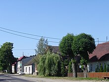
Piasecznik
| Piasecznik | ||
|---|---|---|

|
|
|
| Basic data | ||
| State : | Poland | |
| Voivodeship : | West Pomerania | |
| Powiat : | Powiat Choszczeński | |
| Gmina : | Choszczno | |
| Geographic location : | 53 ° 14 ' N , 15 ° 18' E | |
| Height : | 44 m npm | |
| Residents : | 440 (2007) | |
| Postal code : | 73-200 | |
| Telephone code : | (+48) (+48) 95 | |
| License plate : | ZCH | |
Piasecznik ( German Petznick ) is a village near Stargard in the West Pomeranian Voivodeship in Poland . It belongs to the Gmina Choszczno (municipality of Arnswalde) in the powiat Choszczeński (Arnswalder district) .
Geographical location
The village is located in Hinterpommern , 15 kilometers southeast of Stargard in Pomerania and 7.5 kilometers southwest of Zachan on the road that leads from Stargard to Arnswalde . There are three lakes near the village, which is not far from the Ihna .
history
Petznick is an old church village. Around 1780 there was a Vorwerk in Petznick, 25 farmers including the off-duty Schulzen, three Kossaten , seven Büdner , a blacksmith, a preacher, a sexton and a total of 73 fireplaces (households).
In the past, the villagers made their livelihoods mainly by farming and raising livestock, as well as fishing in the lakes around the village.
Until 1945 Petznick formed a rural community in the Pyritz district of the Prussian province of Pomerania . The Waldhof residential area also belonged to the community .
In the spring of 1945, towards the end of World War II , Petznick was occupied by the Red Army . Soon afterwards the region was placed under Polish administration together with the whole of Western Pomerania . Poles migrated to. In the following years, the long-established population of Petznick sold . The German village was renamed Piasecznik .
Development of the population
- 1852: 604
- 1933: 582
- 1939: 602
- 2007: 440
Sons and daughters of the place
- Hermann Daniel Hermes (1734–1807), German Protestant theologian, professor in Kiel
- Johann Timotheus Hermes (1738–1821), German poet, novelist and Protestant theologian
- Kurd Schulz (1900–1974), German librarian and writer
Web links
- Petznick at Meyers Gazetteer
Footnotes
- ↑ Ludwig Wilhelm Brüggemann (Hrsg.): Detailed description of the current state of the Royal Prussian Duchy of Western and Western Pomerania . Part II, Volume 1, Stettin 1784, p. 254, No. 2 .
- ↑ Petznick municipality in the Pomeranian information system.
- ^ Topographical-statistical manual of the Prussian state (Kraatz, ed.). Berlin 1856, p. 463 .
- ^ A b Michael Rademacher: German administrative history from the unification of the empire in 1871 to the reunification in 1990. pyritz.html # ew39pyrpetznick. (Online material for the dissertation, Osnabrück 2006).

