
Pilar (Surigao del Norte)
| Pilar parish | |||
| Location of Pilar in the province of Surigao del Norte | |||
|---|---|---|---|

|
|||
| Basic data | |||
| Region : | Caraga | ||
| Province : | Surigao del Norte | ||
| Barangays : | 15th | ||
| District: | 1. District of Surigao del Norte | ||
| PSGC : | 166716000 | ||
| Income class : | 5th income bracket | ||
| Households : | 1630 May 1, 2000 census
|
||
| Population : | 9,752 August 1, 2015 census
|
||
| Coordinates : | 9 ° 52 ' N , 126 ° 6' E | ||
| Postal code : | 8420 | ||
| Geographical location in the Philippines | |||
|
|||

Pilar is a municipality in the Philippines in the province of Surigao del Norte . It is located on the east coast of the island of Siargao in the east of the Philippines. Pilar has 9,752 inhabitants (August 1st 2015 census).
After the community was part of Dapa until 1953 , it gained independence on October 31, 1953 following a corresponding decree by the then President Elpidio Quirino . Pilar's local economy is mainly based on fishing and agriculture, but tourism is also growing in importance. The Magpupungko Beach, popular among visitors, is of particular importance . At high tide a beautiful sandy beach that invites you to swim and dive. When the tide is out, a lagoon with striking rock formations appears.
Barangays
Pilar is politically divided into 15 barangays , of which 4 are classified as urban ( Poblacion ) and 11 as rural barangays:
- Asinan (Pob.)
- Caridad
- Centro (Pob.)
- Consolacion
- Date
- Dayaohay
- Jaboy
- Katipunan
- Maasin
- Mabini
- Mabuhay
- Pilaring (Pob.)
- Punta (Pob.)
- Salvacion
- San Roque

Magpupungko Beach at high tide

Rock formation in Magpupungko

Magpupungko beach
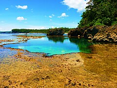
Magpupungko Lagoon


Individual evidence
- ↑ Historical background of Pilar. Archived from the original on May 20, 2014 ; accessed on July 6, 2018 .
Web links
- elgu.ncc.gov.ph - Pilar ( Memento of November 2, 2004 in the Internet Archive )