Pillman Green
|
Pillman Green
Werda municipality
Coordinates: 50 ° 26 ′ 27 " N , 12 ° 16 ′ 44" E
|
||
|---|---|---|
| Height : | 570 m | |
| Incorporation : | October 1, 1938 | |
| Incorporated into: | Cabbage green | |
| Postal code : | 08223 | |
| Area code : | 037463 | |
|
Location of Pillmannsgrün in Saxony |
||
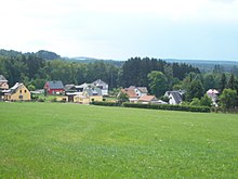
Pillmannsgrün is a district of the district Kottengrün of the municipality Werda in the Vogtlandkreis (Free State of Saxony ). The municipality of Pillmannsgrün with the Jägerswald settlement belonging to it was incorporated into Kottengrün on October 1, 1938, with which it came to the Werda municipality on January 1, 1994.
geography
Location and traffic
Pillmannsgrün forms the northern part of the district of Kottengrün. The Pillmannsgrüner Bach flows through the Pillmannsgrün and flows into the White Elster via the Kottengrüner Bach and the Görnitzbach . The main part of Pillmannsgrün is located between Oelsnitzer Straße ( Staatsstraße 303 ) in the north and Lange Weg in the south. In the north of the district there is the Jägerswald settlement in the southern part of the Jägerswald forest of the same name . It can only be reached from the south via the Zum Jägerswald road. Pillmannsgrün is located in the center of the Vogtlandkreis and in the Saxon part of the historical Vogtland . Geographically, the place is in the east of the natural area Vogtland ( Upper Vogtland ).
Neighboring places
| Mountains with stones | ||
| Tirpersdorf |

|
Who's there |
| Cabbage green |
history
The scattered settlement of Pillmannsgrün was mentioned as "Pilgramsgrun" in 1420/40. In the 15th and 16th centuries, the place was at times a desert . The basic rule on the back of populated place was in the 16th century on a pro rata among the Rütter goods Marieney and Schloditz . In 1791 the manor was at the manor Tirpersdorf in the Electoral Saxon office of Voigtsberg . The Jägerswald settlement, mentioned for the first time this year, however, belonged to the Mechelgrün manor in the Plauen district of Saxony . In the 19th century Jägerswald was counted to Pillmannsgrün. Until 1856 Pillmannsgrün belonged to the Electoral Saxon or Royal Saxon Office of Voigtsberg. In 1856 the place was affiliated to the Falkenstein court office and in 1875 to the Auerbach administration .
On October 1, 1938, Pillmannsgrün was incorporated with Jägerswald to Kottengrün. As a result of the second district reform in the GDR , Pillmannsgrün came as part of the Kottengrün community in 1952 to the Auerbach district in the Chemnitz district (renamed the Karl-Marx-Stadt district in 1953 ), which was continued as the Saxon district of Auerbach in 1990 and became part of the Vogtlandkreis in 1996. When the municipality of Kottengrün was incorporated into Werda, Pillmannsgrün came to the municipality of Werda on January 1, 1994. Pillmannsgrün forms its own area within the district of Kottengrün.
Web links
- Pillmannsgrün in the Digital Historical Directory of Saxony
Individual evidence
- ↑ The Marieney manor at www.sachsens-schlösser.de
- ↑ The Schloditz manor on gov.genealogy.net
- ↑ The manor Tirpersdorf on gov.genealogy.net
- ↑ The Mechelgrün manor at www.sachsens-schlösser.de
- ^ Karlheinz Blaschke , Uwe Ulrich Jäschke : Kursächsischer Ämteratlas. Leipzig 2009, ISBN 978-3-937386-14-0 ; P. 74 f.
- ^ The Auerbach administration in the municipality register 1900
- ↑ Pillmannsgrün on gov.genealogy.net
- ↑ Kottengrün on gov.genealogy.net


