Pingelap
| Pingelap | ||
|---|---|---|
| NASA image from Pingelap | ||
| Waters | Pacific Ocean | |
| archipelago | Carolines | |
| Geographical location | 6 ° 13 ′ N , 160 ° 42 ′ E | |
|
|
||
| Number of islands | 3 | |
| Main island | Pingelap Island | |
| Land area | 1.75 km² | |
| Lagoon area | 1.2 km² | |
| total area | 5 km² | |
| Residents | 438 (2000) | |
| Map of the atoll | ||
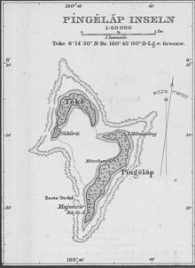
Pingelap (also: Pelelap , Pingerappu To ; English outdated: Musgrave or Mac-Askill Island ) is a west Pacific atoll with three main islands in the state of Pohnpei of the Federated States of Micronesia .
geography
Pingelap represents the easternmost land mass of this Micronesian state. Of this 1.75 km² is land area and 1.20 km² is lagoon ; the rest is taken up by the flooded coral reef. The total area given as 29 km² appears to be significantly excessive in comparison with the satellite image, the actual value should be around five square kilometers. The small lagoon is divided into two basins. The deeper southeast basin is up to 42 meters deep.
The atoll with the islands of Pingelap Island (southeast), Sukoru (west) and Daekae (northwest) is a good 200 kilometers east-southeast of Pohnpei and was discovered in 1793 by Thomas Musgrave . At that time it had been settled for around 800 years. In 1775, however, ninety percent of the then approximately one thousand island residents fell victim to Typhoon Lengkieki ; most of the survivors died of starvation shortly afterwards, as all vegetation, including coconut palms , breadfruit and banana trees , had been destroyed, leaving fish as the only source of food.
In his book Die Insel der Farbblinden , Oliver Sacks reports that, starting with only about 20 survivors, the population has gradually increased again, but in the fourth generation after this environmental disaster, a “new” disease has become noticeable: “The first children with pingelapese eye disease were born, and in the course of a few generations their number had risen to more than five percent of the population - about the value it is still at today. "The population growth had not occurred without inbreeding , which meant that certain genetic traits, which had rarely appeared before and were able to spread through the population. One of them resulted in complete achromatopsia (color blindness): “The mutation responsible for achromatopsia may have occurred centuries before, but it was a recessive gene and as long as the population was large enough, the likelihood remained two carriers of this gene got married and the disease manifested in their children is very small. All of this changed with the typhoon. "
Today around a third of the population is the carrier of the genetic make-up that leads to ametropia, and around 75 of the around 250 inhabitants are color-blind. In other regions of the world there is one color blindness for every 30,000 people. However, those affected by the eye disease state that they see a variety of shades, contrasts and brightnesses, such as when fishing that color-sighted people escape.
Since historical time Pingelap was divided into two districts, Likinepeng (Lehpeng) and Lepeir. Likinepeng is considered the main town of the atoll.
swell
- ↑ ftp://rock.geosociety.org/pub/reposit/2001/2001075.pdf
- ↑ Oliver Sacks : The island of the color blind. Rowohlt Verlag, 1997, p. 57
- ^ Darshan Singh Maini: Genetic Anthropology. Mittal Publications, 2000, ISBN 978-81-7099-783-2 limited preview in the Google book search
Web links


