Oroluk (atoll)
| Oroluk atoll | ||
|---|---|---|
| Map of the Oroluk Atoll | ||
| Waters | Pacific Ocean | |
| archipelago | Carolines | |
| Geographical location | 7 ° 32 ' N , 155 ° 17' E | |
|
|
||
| Number of islands | 1 | |
| Main island | Oroluk | |
| length | 34 km | |
| width | 24 km | |
| Land area | 13 ha | |
| Lagoon area | 420 km² | |
| total area | 453 km² | |
| Residents | uninhabited (2000) | |
| Bay in the northwest of the main island | ||
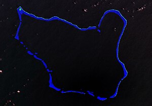
| NASA satellite image of Oroluk | ||
Oroluk is an atoll in the northwest of the state of Pohnpei in the Federated States of Micronesia . The atoll is about 325 km away from Palikir , the capital of the Federated States of Micronesia.
geography
The atoll extends from northwest to southeast for about 32 km and is on average 20 km wide. The only island in the atoll is Oroluk in the extreme northwest, with a land area of 13 hectares . Over 25 narrow, elongated and vegetationless sand islands and banks, especially on the eastern edge of the 420 km² lagoon , which together took up about 37 hectares and barely reached heights of two meters, have been washed away by cyclones over the decades . The total area of the atoll is 453 km². The lagoon is up to 75 meters deep.
history
Oroluk was probably inhabited by Micronesians since the 15th century.
The atoll or the main island was discovered in June 1826 by P. Saliz , captain of the French ship Peruvien , and named Ile de gordelaise . Later the main island of Oroluk was named San Augustine or St. Augustine Island .
In 1861 the British merchant ship Norna ran onto a reef in the north of the atoll. With the lifeboats the sailors managed to get to safety on St. Augustine Island .
In 1899, when Oroluk and the rest of the Caroline Islands were sold by Spain for 17 million marks and became a protected area of the German Empire , the atoll was inhabited by a few families from Kapingamarangi .
In 1914 the atoll was occupied by Japan and the island's population was deported. A population of 4 is given for 1935 (during the Japanese administration).
From the early 1950s there were attempts to resettle people from the overpopulated Kapingamarangi Atoll. In 1954, 10 men from Kapingamarangi worked to establish a permanent settlement on Oroluk. At the 1967, 1973, 1985 and 2000 censuses, the atoll was listed as uninhabited. The last six people were counted in the 1980 census. In 1994 the population was not recorded separately from Kapingamarangi.
use
There is an automatic weather station on the northern tip of the small atoll island of Oroluk .
local community
The 1980 census mentions Oroluk as a separate municipality, as one of twelve municipalities in Pohnpei, to which the Minto Reef also belonged. However, the constitution of the state of Pohnpei no longer mentions Oroluk as a municipality , but only eleven municipalities. Oroluk and Minto Reef are then community-free ( Areas Outside the Local Governments ).
Individual evidence
- ↑ Oceandots ( Memento of 23 December 2010 at the Internet Archive )
- ↑ a b c Pohnpei Census 2000 (PDF; 3.7 MB)
- ↑ The geography of Kapingamarangi Atoll in the Eastern Carolines, by Herold J. Wiens, Atoll Research Bulletin No. 48, June 30, 1956 (PDF; 4.7 MB)
- ^ Constitution of Pohnpei, Art. 14, Local Governments
literature
- Paul F. Holthus, JE Maragos, J. Naughton, C. Dahl, D. David, A. Edward, M. Gawel and S. Liphei: Oroluk Atoll and Minto Reef resource survey. East-West Center, Program on Environment, Honolulu 1993, 94 pages.
Web links
- [1] Heinrich Schnee (Ed.): German Colonial Lexicon . Quelle & Meyer, Leipzig 1920, Volume II, p. 684
- Weather station on Oroluk (with picture)


