Kapingamarangi
| Kapingamarangi | ||
|---|---|---|
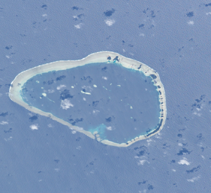
| ISS image by Kapingamarangi | ||
| Waters | Pacific Ocean | |
| archipelago | Carolines | |
| Geographical location | 1 ° 4 ′ N , 154 ° 46 ′ E | |
|
|
||
| Number of islands | 33 | |
| Main island | Tohou | |
| length | 11.6 km | |
| width | 8.3 km | |
| Land area | 1.12 km² | |
| Lagoon area | 61.51 km² | |
| total area | 82.1 km² | |
| Highest elevation | 1 m | |
| Residents | 500 (2007) | |
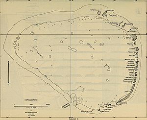
| Map of the atoll (1956) | ||
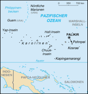
Kapingamarangi is an isolated atoll in the central Pacific Ocean . It is in the extreme southwest of the state of Pohnpei of the Federated States of Micronesia . The atoll is over 750 km away from the capital of the Federated States of Micronesia on the island of Pohnpei .
geography
Kapingamarangi is only 75 km north of the equator ; the nearest landmass is the Nukuoro Atoll in the north, about 300 km away. The total area including the lagoon is 82.1 km², of which 1.12 km² is land area, which is distributed over 33 small palm-covered islands on the east side of the atoll. On the west side, the reef is almost flooded during high tide.
The atoll has about 500 inhabitants (2007). It forms a municipality in the Micronesian state of Pohnpei . The main island and seat of the community and the chief is Touhou , which protrudes about a meter from the sea and is connected to the island of Veilua ( Ueru ) in the north by a narrow dam.
language
The inhabitants speak the Kapingamarang language . This is a dialect belonging to the Samoan branch of the Polynesian languages . Therefore Kapingamarangi belongs to the outside of the Polynesian triangle lying Exklaven Polynesia .
Islands
The 33 islands from north to south, running along the eastern edge of the atoll, are (with area data):
| No. | Motu | Area ( ha ) |
Inhabitants 1947 |
|---|---|---|---|
| 1 | Torongahai | 7.89 | |
| 2 | Ring tutori | 10.80 | |
| 3 | Rikumanu | 0.36 | |
| 4th | Turuaimu | 0.81 | |
| 5 | Pepeio | 0.28 | |
| 6th | Nunakita | 5.75 | |
| 7th | Hukuniu | 0.36 | |
| 8th | Parakahi | 1.25 | |
| 9 | Werua | 16.75 | 183 |
| 10 | Touhou | 3.72 | 293 |
| 11 | Taringa | 5.02 | 31 |
| 12 | Pungupungu | 0.16 | |
| 13 | Matiro | 4.17 | 13 |
| 14th | Matuketuke | 0.40 | |
| 15th | Ramotu | 1.42 | |
| 16 | Sakenge | 0.93 | |
| 17th | Matawhei | 0.28 | |
| 18th | Hukuheua | 2.02 | 7th |
| 19th | Hepepa | 0.93 | |
| 20th | Tipae | 0.65 | |
| 21st | Tetau | 3.16 | |
| 22nd | Nikuhatu | 0.93 | |
| 23 | Takairongo | 1.58 | |
| 24 | Tangawaka | 2.83 | |
| 25th | Hare | 32.17 | |
| 26th | Herokoro | 1.54 | |
| 27 | Tirakau | 0.73 | |
| 28 | Tariha | 0.89 | |
| 29 | Tiahu | 0.24 | |
| 30th | Tokongo | 0.73 | |
| 31 | Tirakaume | 0.53 | |
| 32 | Pumatahati | 2.55 | |
| 33 | Matukerekere | 0.01 | |
| Kapingamarangi | 111.85 | 527 |
Five islands are permanently inhabited. The distribution of the population across the islands is known from 1947. Other islands have residential buildings, but are not inhabited all year round, but only for the production of copra . Hare, for example, had 29 residential buildings (1947).
history
On the map of Friedrich Benjamin von Lütke from 1828 the atoll is marked with a question mark under the Micronesian name Pyguirame .
Kapingamarangi may have been discovered by Hernando de Grijalva as early as 1537 , but the first sure discovery was made by Edmund Fanning on the 'Tonquin' on April 25, 1809.
In 1825 (exact dates are not known) two sightings took place:
- by the British whaling ship Greenwich , Emmett Master, owned by Samuel Enderby
- and by Prince B. Mooers of the American whaling ship Spartan
Other sightings were:
- 1827, Atlantic whaling ship off Nantucket , Master John J. Gardner.
- December 20, 1853 by commandant Tardy de Montravel of the French corvette La Constantine
- September 8, 1864 by W. Symington from Northfleet , home port London
- August 21, 1865 the Spanish frigate Berenguela
From 1899 to 1914 Kapingamarangi was part of the German colony of German New Guinea .
In August 1914, the atoll was occupied by the Japanese Navy. In 1916 part of the population was resettled to Pohnpei, where around 1500 Kapingamaranginers who speak their mother tongue still live today (2011).
A curiosity is that Kapingamarangi, called pescadores during the Spanish colonial era , like three other mini-archipelas in Micronesia, was obviously forgotten in the German-Spanish treaty of 1899 , and is therefore legally still Spanish territory. However, due to its minor importance, the land does not claim ownership.
Individual evidence
- ↑ The geography of Kapingamarangi Atoll in the Eastern Carolines, by Herold J. Wiens, Atoll Research Bulletin No. 48, June 30, 1956 (area data converted; PDF; 4.7 MB)
- ↑ The geography of Kapingamarangi Atoll in the Eastern Carolines, by Herold J. Wiens, Atoll Research Bulletin No. 48, June 30, 1956 (area data converted; PDF; 4.7 MB)
- ↑ Litke, Fedor Petrovič: Voyage autour du monde, exécuté par ordre de Sa Majesté l'Empereur Nicolas Ier., Sur la corvette Le Séniavine, pendant les années 1826, 1827, 1828 & 1829: partie historique; Paris, part [4]: Atlas / lithography après les dessins originaux d'Alexandre Postels et du Baron Kittlitz; [1835], plate [3]
- ^ Sharp, Andrew: The discovery of the Pacific Islands; Oxford 1960, pp. 24-26 and 209
- ^ Riesenberg, Saul H .: Six Pacific island discoveries; in: The American neptune, vol. 34; Salem, Mass. 1974 (pp. 249-257), pp. 256f.
- ↑ Findlay, Alexander George: A directory for the navigation of the North Pacific Ocean, with descriptions of its coasts, islands, etc., from Panama to Behring Strait, and Japan; London 1886 (3rd ed.), P. 988; see. Jones, AGE: Ships employed in the South Seas trade, Vol. 2; Canberra & Burwood, Vic. [1992], p. 478 et al. 479
- ^ Sharp 1960, p. 209
- ^ Stackpole, Edouard A .: The sea-hunters: the New England whalemen during two centuries, 1635 - 1835; Philadelphia & New York 1953 (1st ed.), Pp. 373/74
- ↑ Annales hydrographiques, T. 10; Paris 1855, pp. 168-169; with view and map
- ^ [Symington, W .:] Non-existence of Simpson Island, South Pacific, - Position of Tasman Island; and in the North Pacific that of Greenwich Island; in: The nautical magazine and naval chronicle, Vol. 34; London 1865 (pp. [225] -227), pp. 226/27; cf .: Greenwich Island - N. Pacific; in: Mercantile marine magazine and nautical record, Vol. 12; London 1865 p. 163; cf. Findlay / North Pacific; 1886 p. 988
- ↑ Les îles Grenwich [sic!]; in: Annales hydrographiques; 1866, pp. 670-71; see. Findlay / North Pacific; 1886, p. 988
- ↑ Thilenius, Hambruch: Kapingamarang , in: Deutsches Koloniallexikon , Volume III, Leipzig 1920, p. 479.


