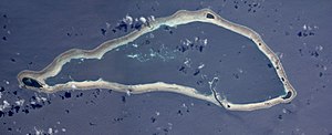
Sapwuahfik
| Sapwuahfik | ||
|---|---|---|
|
ISS photo mosaic of the atoll (main island Ngatik far left) |
||
| Waters | Pacific Ocean | |
| archipelago | Carolines | |
| Geographical location | 5 ° 49 ′ N , 157 ° 17 ′ E | |
|
|
||
| Number of islands | 10 | |
| Main island | Ngatik | |
| length | 22.5 km | |
| width | 9.6 km | |
| Land area | 1.75 km² | |
| Lagoon area | 78.56 km² | |
| total area | 114 km² | |
| Residents | 640 (2000) | |
| Location of the atoll | ||
Sapwuahfik , formerly Ngatik , is an inhabited atoll in the Micronesian state of Pohnpei . It is located about 150 kilometers southwest of the island of Pohnpei .
The wedge-shaped atoll has ten islands of very different sizes, which are exclusively located on the narrow fringing reef. The main inhabited island of Ngatik is located in the far west of the atoll.
The atoll was discovered by Felipe Tompson in 1773.
Islands
The islands clockwise, starting with the main island Ngatik in the west: Map with all coordinates: OSM | WikiMap![]()
| island | Area km² |
location | Coordinates |
|---|---|---|---|
| Ngatik | 0.906 | Western tip | 05 ° 47 ′ 19.0 ″ N , 157 ° 09 ′ 34.0 ″ E |
| Peina | 0.206 | north | 05 ° 51 '12.0 " N , 157 ° 17' 32.0" E |
| Bigen Karakar | 0.025 | Northeast | 05 ° 49 '48.0 " N , 157 ° 19' 35.0" E |
| Jirup | 0.023 | east | 05 ° 48 ′ 37.0 " N , 157 ° 20 ′ 16.0" E |
| Bigen Kelang | 0.047 | east | 05 ° 48 '03.0 " N , 157 ° 20' 28.0" E |
| Pikepe (Piken Mategan) | 0.009 | east | 05 ° 47 '46.0 " N , 157 ° 20' 32.0" E |
| Dekehnman | 0.009 | Eastern tip | 05 ° 47 '28.0 " N , 157 ° 20' 41.0" E |
| Wat | 0.281 | Eastern tip | 05 ° 47 '09.0 " N , 157 ° 20' 39.0" E |
| Pikenmetkow | 0.006 | southeast | 05 ° 46 ′ 45.0 ″ N , 157 ° 19 ′ 40.0 ″ E |
| Uataluk (Wateiluk) | 0.039 | south | 05 ° 46 '30.0 " N , 157 ° 17' 30.0" E |
| Sapwuahfik (Atoll) | 1.551 | Fringing reef | 05 ° 48 ′ 47.0 " N , 157 ° 16 ′ 36.0" E |
The only permanently inhabited island is the main island of Ngatik. Six other islands (the largest after Ngatik) are cultivated by the inhabitants of the island of Ngatik (harvest of coconuts, cultivation of taro , pigs and chickens) and have a total of 12 accommodation huts.
Web links
- Sapwuahfik on Oceandots ( Memento from December 23, 2010 in the Internet Archive ) (English)
- German Colonial Lexicon
Individual evidence
- ↑ a b Donald W. Buden: The Reptiles of Sapwuahfik Atoll, Federated States of Micronesia ( Memento of the original from June 27, 2010 in the Internet Archive ) Info: The archive link was inserted automatically and has not yet been checked. Please check the original and archive link according to the instructions and then remove this notice. (PDF; 54 kB)
- ^ GeoNames


