
Piz dil Crot
| Piz dil Crot | ||
|---|---|---|
 Piz dil Crot (left) and Piz Miez / Cimalmotta (right), taken from Lago di Lei |
||
| height | 2846 m above sea level M. | |
| location | Border canton Graubünden , Switzerland / Province Sondrio , Italy | |
| Mountains | Oberhalbsteiner Alps | |
| Dominance | 0.64 km → Pizzo Crotto | |
| Notch height | 116 m ↓ Passo Crotto | |
| Coordinates , ( CH ) | 46 ° 29 '31 " N , 9 ° 25' 42" O ( 752 755 / 150884 ) | |
|
||
 Summit of Piz dil Crot |
||

The Piz dil Crot (from Lombard crot , rock cave, rock cellar ' to ancient Greek κρύπτη crypta , German ‹covered passage, grotto, crypt›) is a mountain south of Innerferrera on the border between the Swiss canton of Graubünden and the Italian province of Sondrio with an altitude from 2846 m above sea level M. southeast of the summit is the Lago di Lei .
Location and surroundings
The Piz dil Crot belongs to the Piz Timun chain, a sub-group of the Oberhalbsteiner Alps . The border between the municipality of Ferrera , Canton of Graubünden , Switzerland , and the Italian province of Sondrio runs above the summit . The Piz dil Crot is bordered in the west by the Val Niemet and in the east by the Valle di Lei.
The neighboring peaks include Piz Miez / Cimalmotta in the north and Pizzo Crotto in the south. The Piz della Palù and the Piz Timun are even further south .
Towards the southwest, the Dufourspitze, 135.1 km away, is visible. The farthest visible point ( 45 ° 34 '54.5 " N , 7 ° 53' 56.8" O ) is located 330 meters south of the Rifugio Mombarone ( Alpi Biellesi ) in the Italian province Biella ( Piedmont ) and 155 , 5 km away.
To the southeast of the mountain is the Lago di Lei .
The valley is Innerferrera . A frequent starting point is the dam of the Lago di Lei.
Routes to the summit
Over the north ridge
- Starting point: Innerferrera ( 1480 m ), Lago di Lei dam ( 1933 m ) or Piz Miez / Cimalmotta ( 2835 m )
- Via: Sattel P. 2774
- Difficulty: L
- Time required: 4 hours from Innerferrera, 2 ¾ hours from the dam or ¾ hours from Piz Miez / Cimalmotta
Over the south ridge
- Starting point: Innerferrera ( 1480 m ) or the Lago di Lei dam ( 1933 m )
- Via: Passo Crotto ( 2730 m )
- Difficulty: L . Immediately after Passo Crotto, a five meter high ledge is climbed using a crack ( II )
- Time required: 4 ¼ hours from Innerferrera or 3 hours from the dam (½ hour from Passo Crotto)
panorama

gallery
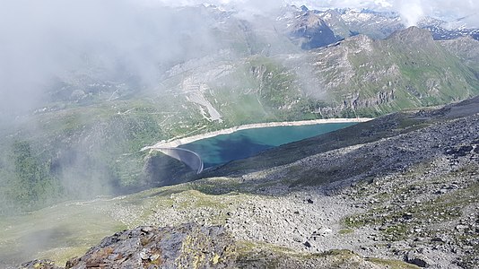
View down to the Lago di Lei
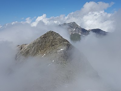
View to the north to Piz Miez / Cimalmotta and Piz Grisch

View from Piz Miez over Piz dil Crot, Pizzo Crotto , Piz della Palù and Piz Timun


literature
- Manfred Hunziker: Club guide, Bündner Alps . Obverse. 1st edition. tape III . Verlag des SAC, 1994, ISBN 3-85902-140-0 , p. 124-125 .
- National map of Switzerland, sheet 1255 Splügenpass, 1: 25,000, Federal Office of Topography, 2012 edition.
Web links
Individual evidence
- ↑ Andrea Schorta: How the mountain got its name . Small Rhaetian name book with two and a half thousand geographical names of Graubünden. Terra Grischuna Verlag, Chur and Bottmingen / Basel 1988, ISBN 3-7298-1047-2 , p. 80 .
- ↑ Calculated 360 ° panorama ( U. Deuschle ; information ) from Piz dil Crot