
Pizzo Pianché
| Pizzo Pianché | ||
|---|---|---|
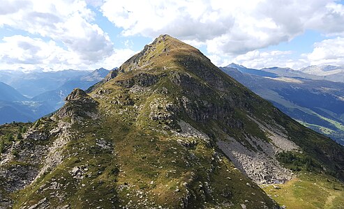
 Pizzo Pianché (right) and in the middle behind Pizzo Erra , taken by the Pianca Bella . |
||
| height | 2228 m above sea level M. | |
| location | Canton Ticino , Switzerland | |
| Mountains | Gotthard massif | |
| Dominance | 0.539 km → Pizzo Erra | |
| Notch height | 99 m ↓ Passo dei Laghetti | |
| Coordinates | 712 638 / 143260 | |
|
||
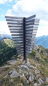
 Steinmann on the junction southwest of Pizzo Pianché |
||

The Pizzo Pianché probably from the Italian pianca for steep pasture slope or wild hay meadow is a mountain between Acquarossa and Faido in the canton of Ticino in Switzerland with an altitude of 2228 m above sea level. M. In SAC club guide and on old topographic maps , the height of 2,227 meters indicated.
Location and surroundings
The Pizzo Pianché belongs to the Gotthard massif . It is located between Pizzo Erra and the Matro in the municipality of Acquarossa . The Pizzo Pianché is bordered in the northeast by the Valle di Blenio and in the southwest by the Valle Leventina . He advances from the ridge between Pizzo Erra and the Matro towards the Valle di Blenio. Towards the Alpe Tarch (north), the Pizzo Pianché has steep cliffs, but the Foppa di Röslugh (south-east) it girds on softer flanks.
The neighboring peaks include the Pizzo Erra in the northwest and the Croce di Sasso , the Pianca Bella , the Cogn and the Matro in the southeast.
Line crossing

The ridge hike from the Passo dei Laghetti ( 2129 m ) to the Matro ( 2172 m ) is a scenic and varied day hike. It offers a great panoramic view of the Valle di Blenio , the Valle Leventina and the surrounding mountains. With a detour to Pizzo Pianché, five peaks are reached. These are from northwest to southeast the Pizzo Pianché ( 2228 m ), the Croce di Sasso ( 2132 m ), the Pianca Bella ( 2165 m ), the Cogn ( 2166 m ) and the Matro ( 2172 m ). The route is partly marked with small, yellow dots. Often there is also a path that partly leads past the bumps next to the edge of the ridge.
The ridge crossing from Passo dei Laghetti to Matro takes about 1½ hours and is indicated with difficulty EB .
Routes to the summit
From the Passo dei Laghetti
From the matro
|

Over the eastern flank
- Starting point: Tizzerascia ( 1277 m )
- Via: On the hiking trail via Brusacu, Garina ( 1634 m ), then leave the path to the southwest and walk over slopes made of grass, rocks and bushes without difficulty.
- Difficulty: EB
- Time required: 2½ hours
panorama

gallery

View in southeast direction to Croce di Sasso , Pianca Bella , Cogn and Matro , taken from the orographic junction southwest of Pizzo Pianché.
View to the northwest to Pizzo Erra , taken from the orographic junction southwest of Pizzo Pianché.

The Riviera , taken from the orographic junction southwest of Pizzo Pianché.
Avalanche barriers on the ridge between Pizzo Pianché and Croce di Sasso


literature
- Giuseppe Brenna: Club Guide, Ticino Alps, Volume III (From Piora to Pizzo di Claro). Verlag des SAC, 1996, ISBN 3-85902-163-X , p. 175.
- National map of Switzerland, sheet 1273 Biasca, 1: 25000, Federal Office of Topography, 2014 edition.
Web links
Individual evidence
- ↑ Petrini, D .; Glossario dialettale. G. Brenna (a cura di), Alpi Ticinesi Ovest, Bellinzona (1989).