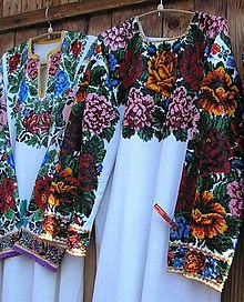
Pokutia
Pokutien ( Ukrainian Покуття Pokuttja , Romanian Pocuția , Polish Pokucie ) is located in the southeastern corner of Galicia in what is now the Romanian-Ukrainian border area.

location
This landscape is naturally enclosed by five rivers. The Dniester forms the northern border and the Cheremosh (Черемош) in the east marks the border with Bukovina . In the south, the White Tisza gorge forms the border with the Maramureş district . The Black Tisza and the Golden Bistritz form the western border of Pokutien.
history
The name Pokutien has been used as an area designation since the end of the 17th / beginning of the 18th century. Pokutien is derived from the Slavic word kut , which means "corner" in German. It is very likely that it refers to the angular, rugged rocks and the curvy, hilly high mountain landscape, but the geographical location must also be taken into account, as it forms a wedge between Bukovina and Transcarpathia. The historical Pokutien nowadays forms the eastern half of the Ukrainian administrative region Ivano-Frankivsk Oblast . The capital of this district is Ivano-Frankivsk , which was called Stanislau until 1962. For tourist purposes as well as to delimit historical events or cultural peculiarities, the term Pokutien is sometimes used as the overall name for the Ivano-Frankovsk district. In 1349 the region came under Polish rule. In the 14th-16th In the 18th century, the region also belonged to the Principality of Moldova . In 1530 Hetman Jan Tarnowski recaptured Pokutien from the Moldovan prince Petru Rares for the Polish crown.
The population, which has been made up of Russians and Wallachians ( Romanians ) for centuries, is also characteristic of Pokutia . To a certain extent, the historical Pokutien coincided with the Kolomyia administrative district, which was still called by the first Jagiellonians.
After the first partition of Poland , the region was under Austrian rule. In 1919 the seat of government of the West Ukrainian People's Republic was briefly in Stanislau . To establish a Polish-Romanian corridor, Pokutien was occupied by Polish and Romanian troops in May. At the end of August 1919, the Romanian army handed Pokutien over to Poland, where it remained until the Second World War . In 1945 it was incorporated into the Ukrainian SSR.
geography
The Pokutien area is divided into a northern and a southern half by the River Prut . The Prut flows through the district town of Kolomyja , the historic capital of Pokutia. Furthermore, the area spreads west along the Cheremosh River.
The northern half of Pokutien is characterized by a low mountain range, the mountainous foothills of which are used as meadows and fields. The southern part is a high mountain landscape of the eastern forest Carpathians and is also known as the Hutsul country because it is the main settlement area of the Hutsuls . The highest peak of this richly forested mountain world is the Hoverla ( 2061 m ). This domed mountain is sacred to the Hutsuls. Many rivers have their source at the foot of this elevation, including the Prut and the White Tisza, which together with the Black Tisza as Tisza form the largest tributary to the Danube.
Geographically, the Podolian Plateau with its steppes meets the Subcarpathian region on this not very large terrain. Pokutien squeezes into the mountains as a pointed wedge, the edges of which are formed by Prut and Cheremosch.
Residents
In Pokuttya the move Hutsul , Ukrainian ethnic group.
See also
- Bessarabia
- Podolia
- List of historical regions in Ukraine
- List of German names of Ukrainian places
- History of Ukraine
Individual evidence
- ↑ Philippe Henri Bubbles: Pocuce, injuste prius detractum, recepit ... Romanian claims to the area südostgalizische Pokuttya? In: Analele Bucovinei, 1/2014
