Province of Contralmirante Villar
| Province of Contralmirante Villar | |
|---|---|
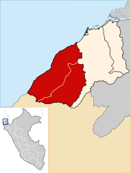
 Location of the province in the Tumbes region |
|
| Basic data | |
| Country | Peru |
| region | Tumbes |
| Seat | Zorritus |
| surface | 2,123.2 km² |
| Residents | 21,057 (2017) |
| density | 9.9 inhabitants per km² |
| founding | November 25, 1942 |
| ISO 3166-2 | PE-TUM |
| Website | municvz.gob.pe (Spanish) |
| politics | |
| Alcalde Provincial | Jesús Alberto Luna Ordinola (2019-2022) |
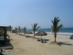
| Punta Sal | |
Coordinates: 3 ° 41 ′ S , 80 ° 41 ′ W
The Contralmirante Villar Province is one of three provinces in the Tumbes region in the far north of Peru . The province is on the Pacific coast . It was named after the rear admiral Manuel Villar Olivera (1801-1889). The province extends over an area of 2123.22 km². In the 2017 census, the population was 21,057. In 1993 the population was 13,361, in 2007 it was 16,914. The administrative seat is the port city of Zorritos .
Geographical location
The province Contralmirante Villar borders to the north and west by the Pacific Ocean, to the east by the province of Tumbes and to the south by the province of Talara ( Piura region ).
Administrative division
The province Contralmirante Villar is divided into three districts ( Distritos ). The district of Zorritos is the seat of the provincial administration.
| District | Administrative headquarters |
|---|---|
| Canoas de Punta Sal | Cancas |
| Casitas | Cañaveral |
| Zorritus | Zorritus |
Individual evidence
- ^ A b Peru: Tumbes Region, Provinces and Districts . www.citypopulation.de. Retrieved December 7, 2019.
