Pulau Langkawi
| Pulau Langkawi | ||
|---|---|---|
| Langkawi at Pantai Cenang | ||
| Waters | Strait of Malacca | |
| Geographical location | 6 ° 21 ′ N , 99 ° 48 ′ E | |
|
|
||
| length | 30 km | |
| width | 25 km | |
| surface | 478 km² | |
| Highest elevation | Gunung Raya 890 m |
|
| Residents | 54,000 | |
| main place | Kuah | |
Pulau Langkawi is the main island and at the same time the name of an archipelago of around 100 limestone islands off the northwest coast of Malaysia .
geography
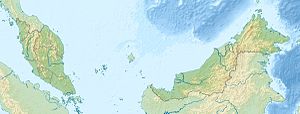
Pulau Langkawi is located in the northern part of the Strait of Malacca , where it opens to the Andaman Sea , near the border between Malaysia and Thailand . A few kilometers away in the north is the neighboring Thai island of Ko Tarutao . Langkawi belongs to the state and sultanate of Kedah within Malaysia . The main town on the island is Kuah .
The entire Langkawi archipelago has an area of 478 km², with the main island Pulau Langkawi having a size of 320 km². Its north-south extension is 25 kilometers a little less than its east-west extension. The interior of the island consists of limestone hills, the highest point of which is Gunung Raya at 890 meters. About two thirds of the island is covered with tropical rainforest .
climate
The climate is shaped by the monsoons and is therefore hot and humid all year round. In contrast to the east coast of Malaysia, there is no “real” rainy season. The wettest season is between August and November. Temperatures usually rise to over 30 ° C during the day and rarely drop below 20 ° C at night.
| Langkawi | ||||||||||||||||||||||||||||||||||||||||||||||||
|---|---|---|---|---|---|---|---|---|---|---|---|---|---|---|---|---|---|---|---|---|---|---|---|---|---|---|---|---|---|---|---|---|---|---|---|---|---|---|---|---|---|---|---|---|---|---|---|---|
| Climate diagram | ||||||||||||||||||||||||||||||||||||||||||||||||
| ||||||||||||||||||||||||||||||||||||||||||||||||
|
Average monthly temperatures and rainfall for Langkawi
Source: Malaysia Meteorological Department ; [2]
|
|||||||||||||||||||||||||||||||||||||||||||||||||||||||||||||||||||||||||||||||||||||||||||||||||||||||||||||||||||||||||||||||||||||||
population
The majority of the Bumiputras ( sons and daughters of the earth ) form the main Muslim , Malay population of Langkawi. In addition to them, there are three smaller population groups: Chinese , whose ancestors were brought into the country by the former English colonial rulers , as well as Indians and Thai .
On the south coast there are settlements of the so-called "sea gypsies", the Orang Laut ( people of the sea , cf. Moken ).
In the interior of the island north of the airport there is a tomb of a Malay princess : Mahkam Masuri. She fell victim to a love drama. When the lady was murdered, she is said to have cursed the island for seven generations. This is said to have been the case until the 20th century . Nice, interesting tomb made of white stone, place of pilgrimage for abandoned wives.
economy
Like Labuan before Brunei, Langkawi is a free trade area . While tourism is the dominant industry on the coasts, the interior of the island is dominated by agriculture (rice cultivation, etc.).
One of the largest events in Langkawi is the LIMA, a military exhibition for ships and aircraft . This takes place every second year (odd years). States from all over the world can offer the Malaysian government armaments projects here. The trading volume is in the billions.
traffic
From the main town of Kuah there are ferry connections to Satun in southern Thailand , to the island of Pulau Penang , to Kuala Kedah, from where you can get to Alor Setar, the capital of Kedah, and to Kuala Perlis in the northwestern Malaysian state of Perlis in around 20 minutes . Since September 2013 a new ferry has been connecting the Kuala Perlis Ferry Terminal with the Tanjung Lembong landing stage on Langkawi. From the port of Telaga in the northwest of the island there is another ferry connection to the Thai island of Ko Lipe (November to May). The Langkawi International Airport is located on the west coast, the load port of Telok Ewa with a cement plant on the north coast. The entire island is accessible with a well-developed road network.
tourism
The island was integrated into the 70 state development projects program “ Wawasan 2020 ” (“Vision 2020”). With this, Malaysia is to become one of the fully developed industrial nations in the period from 1990 to 2020 . In Langkawi, the main focus is on developing an internationally competitive tourism industry, which is already the main livelihood on the island. Large Malaysian corporate groups are encouraged by the state with tax reductions and required by regulations and laws to provide their employees with a vacation retreat in a hotel complex on Langkawi. The government of Malaysia is also trying to attract pensioners from western countries as permanent guests with the “Malaysia, My Second Home” program, whereby the residence permit expressly excludes a work permit.
Although Langkawi suffered only one death from the tsunami on December 26, 2004 , the cancellation rate was 95% of all bookings. From October 2003 to March 2006, Malaysia Airlines operated a direct flight with a Boeing 747 from London, which was abandoned due to rising fuel prices and lack of capacity. At the end of 2006, Langkawi was still affected. Abandoned, partly badly damaged former hotel complexes can be seen along the west coast. Even public beaches still seem untidy there.
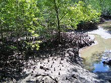
The tourist attractions of Langkawi include the black sand beach in the north ( Pasir Hitham ), the mangrove swamp area on the east coast of the island and the southeast coast, which is especially popular with holidaymakers, especially honeymooners from Malaysia. Monkeys can be seen on the headland to the southeast. Near Kuah in the southeast of Langkawi, the offshore island of Dayang Bunting ( island of the pregnant virgin , the mountain range reminiscent of it in the contour) can be reached by longtail boats, former fishing boats. Pulau Payar Island offers scuba diving or snorkeling and can be reached by ferry. Most of the resorts and hotels are along the west coast beaches.
In 2005, the Langkawi Sky Bridge was opened in the west of the main island . This suspension bridge on Mount Mat Cincang offers an impressive view over the Andaman Sea at a height of 687 meters above sea level. The pedestrian bridge and two viewing platforms on the mountain top can be reached with an approximately 15-minute cable car ride , which starts in the man-made tourist village of Oriental Village .
sport and freetime
The Ironman Malaysia has been held in Langkawi every February since 2000 . In this triathlon over the Ironman distance, the athletes have to swim 3.86 km, cycle 180.2 km, and run 42.195 km.
Individual evidence
- ↑ a b Geography. (No longer available online.) Langkawi-online.com, 2010, archived from the original on April 23, 2015 ; accessed on March 29, 2011 (English). Info: The archive link was inserted automatically and has not yet been checked. Please check the original and archive link according to the instructions and then remove this notice.
- ↑ Langkawi Ro-Ro .
- ↑ Ursula Scheer: Encounters on the planet vacation. In: FAZ.net . November 18, 2013, accessed December 14, 2014 .


