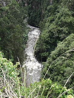
Río Guáitara
|
Río Guáitara - Río Carchi Río Guáytara |
||
|
Río Guáitara near Ipiales |
||
| Data | ||
| location |
|
|
| River system | Río Patía | |
| Drain over | Río Patía → Pacific Ocean | |
| Headwaters | Eastern flank of the volcano of Chile 0 ° 48 ′ 42 ″ N , 77 ° 53 ′ 59 ″ W |
|
| Source height | about 3550 m | |
| muzzle |
Río Patía Coordinates: 1 ° 35 ′ 15 " N , 77 ° 26 ′ 47" W 1 ° 35 ′ 15 " N , 77 ° 26 ′ 47" W. |
|
| Mouth height | approx. 400 m | |
| Height difference | approx. 3150 m | |
| Bottom slope | approx. 20 ‰ | |
| length | approx. 160 km | |
| Catchment area | approx. 1550 km² | |
| Drain |
MQ |
87 m³ / s |
| Left tributaries | Rio Pacual | |
| Right tributaries | Río Curiaco | |
| Big cities | Ipiales | |
| Medium-sized cities | Tulcán | |
| Small towns | Potosí | |
| Communities | Tufiño | |
|
Santuario de Las Lajas |
||
The Río Guáitara (alternative spelling: Río Guáytara ) is an approx. 160 km long left tributary of the Río Patía in Colombia and Ecuador . The upper course along the Ecuadorian border is called Río Carchi .
Naming
The naming of the river is often ambiguous, which is why it is sometimes referred to by the names of the tributaries (e.g. Quebrada de El Morro). Another tributary on the Colombian side bears the name Río Carchi. In ancient times the river was known as Pastarán , among the Incas it was called Ancashmayu and the place was called Guáytara , from which the river takes its name in Colombian territory today.
River course
The Río Guáitara rises on the eastern flank of the volcano of Chile in the area of the Nudo de los Pastos on the border between the Ecuadorian province of Carchi and the Colombian department de Nariño . From there it flows 32 km in a predominantly eastern direction and forms the state border. It passes the municipality of Tufiño and finally reaches the Puente Internacional de Rumichaca ( ⊙ ) bridge . The road bridge connects the cities of Tulcán (Ecuador) and Ipiales (Colombia). The Panamericana border crossing is on it . Below the bridge, in Colombia, the river takes the name Río Guáitara . It flows through a gorge southeast of Ipiales. The regionally important pilgrimage church Santuario de Las Lajas is located there at river kilometer 115 near the small town Potosí . The river is now turning north. The Galeras volcano rises to the east of the river valley . About 12 kilometers above the confluence with the Río Patía, the Río Pacual , the most important tributary, meets the Río Guáitara from the left.
![]() Map with all coordinates: OSM | WikiMap
Map with all coordinates: OSM | WikiMap
Hydrology and catchment area
The mean discharge of the Río Guáitara is 87 m³ / s. The catchment area covers an area of around 1550 km². Of this, about 143 km² are in Ecuador. The western border of the catchment area forms the Colombian Cordillera Occidental with the volcanoes Azufral , Cumbal and Chiles. In the south lies the Nudo de los Pastos mountain group. The basin landscape of Altiplano de Túquerres e Ipiales extends over the southern part of the catchment area . In the east the Colombian Cordillera Central runs with the Galeras volcano.
Web links
Individual evidence
- ↑ a b Alberto Lobo-Guerrero Uscátegui: Hidrología e Hidrogeología de la Región Pacífica Colombiana (PDF, 1.2 MB) Logemin SA. 1993. Retrieved March 31, 2019.

