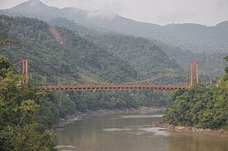
Río Inambari
| Río Inambari | ||
|
Puente Inambari road bridge |
||
| Data | ||
| location |
|
|
| River system | Amazon | |
| Drain over | Río Madre de Dios → Río Beni → Rio Madeira → Amazon → Atlantic Ocean | |
| Confluence of | Río Sandia and Río Huari Huari 14 ° 10 ′ 22 ″ S , 69 ° 18 ′ 11 ″ W |
|
| Source height | approx. 1700 m | |
| muzzle |
Río Madre de Dios Coordinates: 12 ° 42 ′ 53 " S , 69 ° 44 ′ 30" W 12 ° 42 ′ 53 " S , 69 ° 44 ′ 30" W. |
|
| Mouth height | approx. 200 m | |
| Height difference | approx. 1500 m | |
| Bottom slope | approx. 3.9 ‰ | |
| length | approx. 380 km (including Río Sandia: approx. 440 km) | |
| Catchment area | approx. 20,400 km² (according to other sources: 19,905 km²) | |
| Drain on level Puerto Legula |
MQ |
961 m³ / s |
| Discharge at the gauge near the mouth |
MQ |
1320 m³ / s |
| Left tributaries | Río Patambuco, Río Capacmayo, Río Limbani, Río Sacomayo, Río Coaza, Río Pararani, Río Esquilaya, Río San Gabán , Río Sangabán, Río Araza , Río Caychihua | |
| Right tributaries | Río Yahuaramayo, Río Chaspa, Río Dos de Mayo | |
|
Location of the Río Inambari |
||
The Río Inambari is an approximately 380 km (including the source river Río Sandia approx. 440 km) long right tributary of the Río Madre de Dios in southeastern Peru in the administrative regions of Puno and Madre de Dios .
River course
The Río Inambari arises at the confluence of the Río Sandia (left, 60 km long) and Río Huari Huari (right) at an altitude of about 1700 m . The 20 km long Río Huari Huari arises in turn at the confluence of the Río Quiaca (left, 41 km long) and Río Sina (right, 38 km long). The headwaters of the Río Inambari arise on the northern flank of the Cordillera de Apolobamba . This glaciated mountain range in the Peruvian Eastern Cordillera reaches an altitude of 5852 m in the Nevado Ananea . The Río Inambari initially flows 30 km to the northeast. Then it makes a sharp left turn and flows over the next 200 kilometers in the direction of west-northwest through the mountains. It takes up a number of tributaries, mainly on the left. These include: Río Patambuco, Río Capacmayo, Río Limbani, Río Sacomayo, Río Coaza, Río Pararani, Río Curcani and Río Pararani. At river kilometer 164 the Río San Gabán , one of the two most important tributaries of the Río Inambari, flows into the river on the left. The Río Inambari then flows about 60 km in a north-northwest direction. At river kilometer 122 the Río Araza (also Río Marcapata ), the second important tributary of the Rio Inambari, meets it from the left. The Río Inambari turns north for the next 40 kilometers, breaking through a mountain range and reaching the lowlands. He crosses this for the last 70 kilometers in an east-northeast direction. Finally, the Río Inambari meets the Río Madre de Dios, which flows eastwards, 60 km west of Puerto Maldonado .
Catchment area and hydrology
The Río Inambari drains the Peruvian Eastern Cordillera to the northeast. The approximately 20,400 km² catchment area borders on the Río Alto Madre de Dios and the Río Colorado in the west and the Río Tambopata , all tributaries of the Río Madre de Dios, in the east . In the southwest, on the other side of the mountain range, lies the catchment area of Lake Titicaca . The mean discharge of the Río Inambari near the mouth is around 1320 m³ / s.
ecology
A road bridge spans the river directly above and below the confluence of the Río Araza. The latter is the 160 m long Puente Inambari . From there a road leads to the northeastern Puerto Maldonado as well as a trunk road each up the river valley of the Río Araza and the river valley of the Río San Gabán up to the west.
The first hydropower projects, such as the San Gabán II hydropower plant in the catchment area of the Río Inambari, have already been implemented, and others are being planned or under construction. The construction of a 1500 MW hydroelectric power station on the Río Inambari was put on hold by the Peruvian government in 2011. It was supposed to deliver electricity to neighboring Brazil. The planned dam would have flooded a forest area of 410 km² and had a massive impact on the flora and fauna.
Web links
1.6.2.1 Hidrografía de la cuenca del Río Madre de Dios, Domus Consultoria Ambiental (PDF; 1.2 MB) (discharge figures apparently exaggerated)

