Río Moquegua
| Río Moquegua - Río Osmore - Río Ilo | ||
|
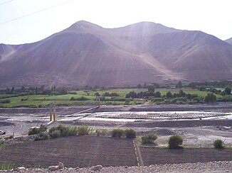
View over the river valley of the Río Moquegua |
||
| Data | ||
| location |
|
|
| River system | Río Moquegua | |
| Confluence of |
Río Huaracane and Río Torata 17 ° 10 ′ 44 ″ S , 70 ° 57 ′ 3 ″ W |
|
| Source height | approx. 1330 m | |
| muzzle |
Pacific Ocean Coordinates: 17 ° 37 ′ 20 " S , 71 ° 20 ′ 33" W 17 ° 37 ′ 20 " S , 71 ° 20 ′ 33" W |
|
| Mouth height | 0 m | |
| Height difference | approx. 1330 m | |
| Bottom slope | approx. 17 ‰ | |
| length | 80 km (with Río Torata: 150 km) | |
| Catchment area | 3480 km² | |
| Left tributaries | Río Tumilaca | |
| Medium-sized cities | Moquegua , Ilo | |
|
Pedestrian suspension bridge over the Río Moquegua |
||
The Río Moquegua is an 80 km long tributary of the Pacific Ocean in the south of Peru in the provinces of Mariscal Nieto and Ilo of the Moquegua region . In the middle and lower reaches, the river also bears the names Río Osmore and Río Ilo .
River course
The Río Moquegua arises on the northern outskirts of Moquegua at an altitude of about 1330 m at the confluence of the Río Huaracane (right) and Río Torata (left). These have their headwaters in the Peruvian Western Cordillera at heights of 4800 m . Including the source river Rio Torata, the total length of the river is 150 km. The Río Moquegua flows along its entire length in a predominantly south-south-west direction. After 2 kilometers the Río Tumilaca meets the river from the left. The river then crosses the desert coastal region of Peru. For the first 22 kilometers, the river valley is several hundred meters wide, so that irrigated agriculture is practiced there. The Panamericana (1S) runs along this section along the river. Later, the Río Moquegua runs for about 40 kilometers in a narrow gorge, before the river valley widens again a little and again irrigated cultivation areas line the river. For the last 12 kilometers, the Río Moquegua turns west and finally flows into the Pacific Ocean on the northern outskirts of Ilo .
Catchment area
The catchment area covers 3480 km². In the north it borders on the Río Tambo , in the south on that of the Río Locumba .
Individual evidence
- ↑ a b Principales cuencas hidrográficas a nivel nacional . Ministerio de Agricultura y Riego. Retrieved August 25, 2019.

