Ilo Province
| Ilo Province | |||
|---|---|---|---|
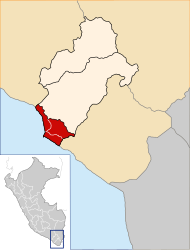
 Location of the province in the Moquegua region |
|||
| Symbols | |||
|
|||
| Basic data | |||
| Country | Peru | ||
| region | Moquegua | ||
| Seat | Ilo | ||
| surface | 1381 km² | ||
| Residents | 74,649 (2017) | ||
| density | 54 inhabitants per km² | ||
| founding | May 26, 1970 | ||
| ISO 3166-2 | PE MOQ | ||
| Website | www.mpi.gob.pe (Spanish) | ||
| politics | |||
| Alcalde Provincial | Gerardo Felipe Carpio Díaz (2019-2022) |
||
| Coast at Ilo | |||
Coordinates: 17 ° 39 ′ S , 71 ° 19 ′ W
The province of Ilo is located in the Moquegua region in southern Peru . The province has an area of 1381 km². In the 2017 census, the population was 74,649. 10 years earlier it was 63,780. The administrative seat is the city of Ilo .
Geographical location
The province of Ilo extends along the Pacific coast in the southwest of the Moquegua region. It has a lengthwise extension in NW-SE direction of 65 km and extends almost 35 km inland. The province lies in the desert, arid coastal region. The Moquegua River flows through the province. The capital Ilo is located on the coast not far from the estuary.
The province of Ilo is bordered by the Arequipa region to the west, the Mariscal Nieto province to the northeast and the Tacna region to the southeast .
Administrative division
The province of Ilo consists of the following three districts. The district of Ilo is the seat of the provincial administration.
| District | Administrative headquarters |
|---|---|
| El Algarrobal | El Algarrobal |
| Ilo | Ilo |
| Pacocha | Pueblo Nuevo |
Web links
- Peru: Moquegua region (provinces and districts) at www.citypopulation.de
- INEI Perú


