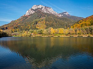
Röthelstein (mountain)
| Röthelstein | ||
|---|---|---|
|
Röthelstein with the Tieberteich in the foreground |
||
| height | 1263 m above sea level A. | |
| location | Styria , Austria | |
| Mountains | Grazer Bergland , foothills east of the Mur | |
| Dominance | 0.84 km → Rote Wand | |
| Notch height | 182 m ↓ Bucheben | |
| Coordinates | 47 ° 19 '35 " N , 15 ° 23' 9" E | |
|
|
||
| rock | Hochlantschkalk | |
| Age of the rock | Devon | |
| particularities | Dragon cave | |
The Röthelstein is a 1263 m above sea level. A. high mountain in the Grazer Bergland in the Austrian state of Styria . It is best known for the location of the Drachenhöhle and its striking appearance above the Middle Mur Valley . Etymologically, the popular climbing mountain shares this name with the village of the same name .
Location and surroundings
The Röthelstein is located in the northern part of the Grazer Bergland on the orographic left bank of the Mur in the municipality of Pernegg . The mountain rises a good 800 m above the valley floor and comes into view when driving on the Brucker Schnellstraße (S 35). The center of Graz is 28 km south, the district capital Bruck an der Mur about 12 km in a north-westerly direction. In the immediate vicinity are the Hochlantsch ( 1720 m ) and the Rote Wand ( 1505 m ), the highest peaks in the Grazer Bergland.
geology
The Röthelstein owes its rugged appearance to its geological structure. The mountain is part of the Graz Paleozoic , the rocks, mainly limestone, come from the Devonian and are therefore around 400 million years old. Stratigraphically, the Röthelstein belongs to the Hochlantsch facies , which differs from the rest of the Graz mountainous region primarily through the pronounced formation of stumps and reefs . Responsible for this are occurrences of various coral species , including the order Rugosa in the ancient sea of Palaeotethys .
Normal way
The usual ascent is from Mixnitz ( 450 m ) over the steep west side of the mountain. Shortly before the Drachenhöhle a steep channel with a safety chain has to be crossed. From the cave the ascent is unmarked, a wooden staircase leads to the partially wooded summit area. The actual summit is on the right and should not be entered out of respect for the ibex (gate) living here. Along the gate, the (also unmarked) path leads gently downhill into the Bucheben, a saddle between Röthelstein and Roter Wand. The ascent from Mixnitz train station takes about 2¼ hours, from the “Rote Wand” car park above Tyrnau (around 880 m ) it takes 1 hour.
Climb
With its numerous climbing routes in various degrees of difficulty, the Röthelstein is one of the most popular climbing mountains in the Grazer Bergland. Most routes lead over the Südostsporn or through the Breite Wand or over the Ratengrat southwest of the summit. Below is a selection of routes with the respective UIAA difficulty level .
- Plate magic (8-)
- Jägersteig (7+)
- Eldorado (6+)
- Land of Smiles (6+)
- UFO (6+)
- Michelangelo (6)
- Elven Garden (5-)
- Winnetou (5-)
- Wigl Wogl (5-)
- Snake Pit (5)
- Postlerweg (4+)
- Sports grouch (4+)
- Old Southwest (4-)
particularities
On the western slope of the mountain, at a height of 950 m, is the entrance to the Drachenhöhle (cadastral number 2839/1 ), one of the most important Neolithic sites in Styria. The cave is unlocked and therefore freely accessible, but may only be entered with a guide. Another well-known cave can be found with the Mathildengrotte (cadastral number 2839/3) at approximately the same altitude on the south side of the mountain.
In the less-used area above the caves, ibex from the local colony can often be found. In addition to the Röthelstein, their habitat includes the Rote Wand and the Hochlantsch.
Literature and maps
- Othenio Abel , Georg Kyrle : The dragon cave near Mixnitz . Speleological Monographs Volume 7/8 and Volume 9. Österreichische Staatsdruckerei, Vienna 1931.
- Günter and Luise Auferbauer: Graz local mountains. With Mur and Mürz valleys . Bergverlag Rother, Munich 2000, pp. 34-35, ISBN 3-7633-4292-3 .
- Freytag & Berndt Vienna, hiking map 1: 35,000, WK 5131, Teichalm - Schöckl - Raabklamm - Weiz - Birkfeld , ISBN 978-3-7079-0606-6 .
Web links
Individual evidence
- ↑ Helmut wing : The geology of the Grazer Bergland. Announcements from the Department of Geology, Paleontology and Mining at the Landesmuseum Joanneum , Graz 1975, p. 35 ff. Online PDF , accessed on May 28, 2019.
- ↑ Günter and Luise Auferbauer: Grazer local mountains. With Mur and Mürz valleys (see literature)
- ^ Grazer Bergland: Climbing. Retrieved January 30, 2015 .
- ↑ Bergstieg.com. Retrieved January 30, 2015 .
Remarks
- ↑ As of May / June 2015, however, climbing from the Drachenhöhle is not advisable, as storm damage (fallen trees) make it difficult to find your way and damage the wooden ladder.


