
Reach (Cambridgeshire)
|
Reach rake |
|||
|---|---|---|---|
 |
|||
| Coordinates | 52 ° 16 ′ N , 0 ° 18 ′ E | ||
| OS National Grid | TL570662 | ||
|
|||
| Residents | 358 | ||
| surface | 10.44 km² (4.03 mi² ) | ||
| Population density: | 34 inhabitants per km² | ||
| administration | |||
| Post town | Cambridge | ||
| ZIP code section | CB25 | ||
| prefix | 01638 | ||
| Part of the country | England | ||
| region | East of England | ||
| Shire county | Cambridgeshire | ||
| District | East Cambridgeshire | ||
| British Parliament | South East Cambridgeshire | ||
| Website: http://www.reach-village.co.uk/ | |||


Reach is a civil parish in Cambridgeshire , England , on the edge of the marshland of East Cambridgeshire . The two spellings Reach and Reche can be found on the village sign .
location
The site is at the north end of the historic Devil's Dyke fortifications and at the beginning of the Reach Lode canal . It is also on the border between marshland and higher land. Immediately in the center of the village begins a low ridge extending to the south, which soon reaches a height of 15 m above sea level. Reach is about 2.5 km west of the much larger town of Burwell .
history
Reach was an important trading and port center in the early Middle Ages . The name is probably derived from the location on a strip of land ( Old English : rece ) directly on the water. With its simple port, the place served as a transshipment point for goods that were to be transported from land on the waterways in the Fen area. The port has been shown to have been in commercial use from at least 1125 until its closure around 1885. During this time, Reach also exported building materials extracted from nearby quarries to various locations accessible by water from here. The Reach Lode Canal is part of a system of waterways that runs through the Fen area to the North Sea. It is always assumed that these canals date from Roman times, they have been documented since the 1070s at the latest. The canal still exists today, is still navigable for non-commercial vehicles and connects Reach to the River Cam .
The rampart and moat of Devil's Dyke divided the settlement into two parts, the west of which was always the more populous. The fortifications within the place were partially demolished in the 13th century. By the 18th century at the latest, the remains were removed and the ditch filled in to build today's central event site.
Reach was only granted parish status in 1954, before that it was a small settlement on the border of the parishes of Burwell and Swaffham Prior . The two parts were sometimes referred to as East Reach and West Reach between 1600 and 1800. Ecclesiastically, the place belonged to Swaffham Prior for most of its history, but now forms a common parish with Burwell.
From the 13th century until 1552 there was a small chapel in the village. Today's village church, originally Holy Trinity School Church and later renamed St. Etheldreda , was built in 1860 on the site of this previous chapel. Parts of the Gothic masonry of the old chapel are still visible behind the new church. From 1860 to 1960 the place had its own small school.
Reach Fair
Reach Fair , one of the oldest annual fairs in England , is held in town every year . The market was originally held around Ascension Day , but today it always takes place on bank holidays at the beginning of May . The charter was issued by King John in 1201 . Historically, the market was of great regional importance and usually lasted three days. It is held today in the town's central Fair Green square. It is said to have only been canceled twice during its existence. Originally, Reach Fair had the character of a market for the trade in goods of all kinds. From the 15th century the focus shifted first to a cattle market and from 1900 to a pure folk festival .
A tradition of the fair is for the mayor and other council members to throw coins into the crowd intended for the local youth.
village life
In the village there is the inn "The Dyke's End," which has been preserved by the villagers in 1999 before the closure and 2005 an official visit of Prince Charles received. It is the last of seven inns that Reach had in the 19th century.
The primary school Swaffham Prior Primary School is initially available for schooling, followed mostly by Bottisham Village College in the neighboring villages. There are secondary schools in Cambridge .
photos
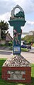
Village sign in the center: Reach

Village sign in the center: Reche
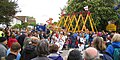
The Reach Fair 2009
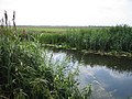
The Reach Lode canal
.jpg)


literature
- ONS (Ed.): Key Figures for 2011 Census: Key Statistics. Area: Reach (Parish) . 2013 ( online [accessed February 2, 2013]).
- Wareham, Wright: A History of the County of Cambridge and the Isle of Ely . tape 10 , 2002, p. 224–230 ( online [accessed December 16, 2015]).
Individual evidence
- ↑ Homepage of St. Mary's Congregation in Burwell. Retrieved December 17, 2015.
- ↑ Cambridge News online report on Reach Fair 2013 . Retrieved December 16, 2015.
Web links
- Homepage of Reach Village
- Dyke's End Pub