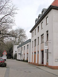
Rehnstoben
| Rehnstoben | |
|---|---|
| Street in Braunschweig | |
| Rehnstoben 2006 | |
| Basic data | |
| place | Braunschweig |
| District | Downtown |
| Created | 14th Century |
| Hist. Names |
die Kerbe (1320), rodenstoven (1542), Röenstuben (1671), Rennstobe (1753) |
| Cross streets | Kaiserstrasse |
| Buildings | former Inselwall / Bosselgraben bunker |
| use | |
| User groups | Foot traffic |
| Technical specifications | |
| Street length | 85 m |
Rehn Toben was a dead end in the precincts of Neustadt the city of Braunschweig . Like the Nickelnkulk not far from it, the road no longer exists today after it was completely destroyed in the Second World War .
etymology
The dead end, which once branched off slightly northwest of Kaiserstraße and as an extension of Reichsstraße , was called the notch between 1320 and 1561 (→ Abelnkarre in the soft picture of Hagen ). In 1394 the area was named de bomgarden, dat de kerne het, before the nyckerkulke ( the tree garden, which is called 'the notch', before the Nickelnkulk ) and in 1426 as de garden, de heten is de kerne ( the garden, the 'the notch 'is called ). In 1520 the treasurer Ludeke Peyne sold his hus, rodenstoven unde garden genomet de kerne ( house, hops darre [ stove actually means room ] and garden, called 'the notch' ). In 1542 the area was then exclusively designated as rodenstoven .
From the name Rodenstoven (for a drying room for hops) over the centuries a. a. initially Röenstuben (1671), Rönestoben (1731) and Rennstobe (1753). In the address book of Oker-Department and the City of Brunswick for the year 1813 is racing romp recorded, from 1850 finally permanently Rehn Toben was.
Anton August Beck interpreted the name in 1758 as coming from a racetrack for knight games , while Karl Scheller believed he recognized a gutter pool in it.
history

The area has been proven to have been inhabited since at least the early 14th century. At the upper end was a garden, which in turn was bordered at its northern end by the Bosselgraben , which in 1356 belonged to Conrad and Hans van der Molen. Most of this garden, which probably belonged to the property with the insurance number 1237 on Nickelnkulk, was merged with another property in 1778, on which Henry Litolffs Verlag was then established .
In the cul-de-sac there were a few, unadorned half-timbered houses in which poorer population groups of the city lived. Some of the houses had to make way for an extension to the expanding Litolff Verlag in 1907.
World War II, destruction and abolition
In 1940, in the second year of the Second World War, one of the first six air raid shelters was built in the northeastern area of the Rehnstoben . The three-story reinforced concrete building with a basement and planned for 610 people is still largely available today and is used as a work building by the Bundesvereinigung Lebenshilfe . In connection with this bunker construction, large bunkers were also built not far from it in Kaiserstraße and Okerstraße, which are still preserved today (→ Bunker in Braunschweig ).
Most of the half-timbered Neustadt around the Wollmarkt fell under the fire storm that lasted several days , which was triggered by the most devastating bomb attack on the city on October 15, 1944 - including the Rehnstoben.
post war period
Due to the total destruction, the Rehnstoben could no longer be inhabited or used, except for the bunker. In the course of the bunker conversion and the construction of a new Lebenshilfe building on the east side, the street name was finally canceled. Today only a bistro in this new building bears the name “Rehnstoben” as a reminder.
literature
- Wolfgang Ernst: Places of survival - Bunker in Braunschweig. From planning to the present. In: Braunschweiger workpieces. Volume 108. Appelhans Verlag, Braunschweig 2006, ISBN 3-937664-42-4 .
- Jürgen Hodemacher : Braunschweig's streets, their names and their stories. Volume 1: Inner City. Cremlingen 1995, ISBN 3-92706-011-9 , pp. 270-271.
- Heinrich Meier : The street names of the city of Braunschweig. In: Sources and research on Brunswick history. Volume 1, Zwissler, Wolfenbüttel 1904, p. 86 ( digitized version ), DNB 58068654X .
- Norman-Mathias Pingel: Rehnstoben. In: Luitgard Camerer , Manfred Garzmann , Wolf-Dieter Schuegraf (eds.): Braunschweiger Stadtlexikon . Joh. Heinr. Meyer Verlag, Braunschweig 1992, ISBN 3-926701-14-5 , p. 189 .
Web links
Individual evidence
- ↑ a b c d e Heinrich Meier: The street names of the city of Braunschweig. P. 86.
- ↑ Herbert Blume : Book review: Braunschweig's streets, their names and their stories. Volume 1: Inner City. Cremlingen 1995, In: Braunschweigische Heimat Heft 81-82, 1995, p. 107.
- ^ A b Norman-Mathias Pingel: Rehnstoben. P. 189.
- ↑ Wolfgang Ernst: Places of survival - Bunker in Braunschweig. P. 81.
- ↑ Wolfgang Ernst: Places of survival - Bunker in Braunschweig. P. 82.
- ↑ Wolfgang Ernst: Places of survival - Bunker in Braunschweig. P. 85.
Coordinates: 52 ° 16 ′ 10.3 ″ N , 10 ° 31 ′ 13.5 ″ E


