
Abeln cart
| Abeln cart | |
|---|---|
|
|
|
.JPG) |
|
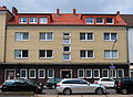
| View into the Abelnkarre from the southwest (2013) | |
| Basic data | |
| place | Braunschweig |
| District | Hagen |
| Created | 13th Century |
| Hist. Names | de kerne (1346), Valberges kerne (1389), Abelenkarne (1502) |
| Cross streets | Wilhelmstrasse (in the west), Schöppenstedter Strasse (in the east) |
| Buildings | Kalm's house |
| use | |
| User groups | Pedestrian traffic , bicycle traffic , car traffic |
The Abelnkarre is a small street in the soft area of Hagen in Braunschweig . It connects Wilhelmstrasse with Schöppenstedter Strasse .
history


Etymology of the name
Together with hat filters , Kattreppeln , Nickelnkulk and a few others, the Abelnkarre is one of those Braunschweig street names whose etymology is unclear or at least left room for speculative interpretations for centuries.
Middle Low German was spoken in Braunschweig in the 14th and 15th centuries . The street had different names from the 14th century to 1671, with the Middle Low German words “de kerne” or “karne” or “karve” and “de twete” or compositions with them predominating. “Kerne”, “karne”, “kerve” and “karve” are synonymous with “ twete ”, ie a short, narrow passage between neighboring rows of houses. Street names with “Twete” are often to be found in Braunschweig (→ List of Tweten in Braunschweig ), such as Bolchentwete, Kaffeetwete, Kupfertwete, Opfertwete and a dozen others. In 1389 the street was called "Valberges kerne". This is the name given to the corner house at the southern end, which was named after its owner as early as 1349: "Bossen Valberges hus, dat steyt by the grave up dem horne, tub men in de kerne geit". In the period after that, the little street was only referred to as “de kerne” or “de twete”, as was the case in 1344 and 1349 in the first degeding book of the Hagens. The meaning of the Middle Low German word “kerne” or the linguistically rule-compliant variant “karne” was “ notch ”. 1357 the connection is called “twete” in the same book. Around 1502 the name “Abelenkarne” appears for the first time, which is similar to today's street name, then in 1671 “In der Abelen Karben” and finally in 1758 the form “Abelnkarre”, which is still used today.
Reason for the name change
The original name and the reason for the renaming were unclear for a long time and caused numerous speculations. The suggestion that there was a resident named “Abel” or a cart maker in the street was refuted, as no one with a similar name ever lived there. As early as 1841, Emil Ferdinand Vogel indicated the following in his book Alterthümer der Stadt und des Landes Braunschweig : "This street is not called Abeln Karre, but Abeln notch - or cut - a street with no exit."
The Germanist Herbert Blume explained in 1994 that “kerne” or “karne” are a glossing over and disguising metaphor , in the present case for a “cut between two elevated formations”. Therefore, the road was originally "arskerne" (= "ass notch," as vulgar term for gluteal fold (sulcus gluteus)), told. “Kerne” or “karne” was therefore the shortened version for this narrow street with half-timbered houses . Blume cited several examples of names from the area. For example, in 1569/70 in Helmstedt, 40 km east of Braunschweig, the name of a street as "Arschkerbe" can be proven (which is documented in 1523 under the name "Abelnkarre"). The street has been called "Stolzengasse", which is still valid today, since the early 19th century. The street name "Abelnkarre" can also be found in Schöppenstedt , a small town about 30 km southeast of Braunschweig, and in Schöningen , another 10 km east of Schöppenstedt. The street “Erskar” in Burg auf Fehmarn still bears the same significance today . In his work, Words and Their Fates , which appeared for the first time in 1935, Adolf Josef Storfer listed other such crude street and field names in numerous German cities. B. in Breslau, Danzig, Elbing, Frankfurt am Main, Königsberg, Lübeck, Lüneburg, Marienwerder, Münster, Rostock or Wismar. Often these were dead ends . Over time, however, these names, perceived as obscene by the locals, have been changed - some of them beyond recognition today.
According to Blume, the reason for the renaming is the " process of civilization " ( Norbert Elias ), which the city population went through since the late Middle Ages and during which there was, among other things, a "progressive privatization and tabooing of the physical". The attempt was made to replace embarrassing, crude or obscene words that ran counter to the shame of the time with harmless to nonsensical such as B. to replace allergens or window paste. According to Blume, this change could have taken place or began in the 16th century. That it as already in Braunschweig for "intentionally nonsensical twist" and "distortion" of the "unspeakable perceived" street name in the near Helmstedt, Schöppenstedt and Schoningen arskerne the "wrong but socially acceptable " Abel truck came, Flower leads to the "role model" of Big city towards the small townspeople and villagers.
Buildings
_um_1900.jpg&filetimestamp=20110615180502&)
.JPG)
At the western corner of the Abelnkarre towards Wilhelmstraße was the south gable of the Kalmschen House, built in 1619 and renovated in 1857 (Wilhelmstraße 95, insurance number 1892), named after its owner, Mayor Werner Kalm . The stately, 25-span-long house had two storeys and was built of stone on the two lower floors and half-timbered above . From 1830 until it was completely destroyed by one of the numerous bombing attacks of World War II , it served as a community school for girls. Get remained only the Renaissance - Portal , which was added in 1954 and now in building national route 15 as a passage into the Opfertwete located.
There was also a brewery in the street that brewed so-called convention or harvest beer. In the 1930s, the family of Willi Steinfass (1892–1933) lived in Abelnkarre 10. He was an unskilled worker at MIAG and a member of the KPD . Steinfass was one of the eleven victims of the so-called Rieseberg murders committed on July 4, 1933 by members of the SS in the village of Rieseberg , 20 km east of Braunschweig .
During the Second World War, the Abelnkarre, which mainly consisted of half-timbered houses, as well as those within a radius of several hundred meters , was completely destroyed by Allied bombing, especially on October 15, 1944 , and during the reconstruction from the early 1950s onwards through uniform housing developments Replaced north side of the street. The south side has not been rebuilt to this day. Instead, a few meters back, a supermarket complex with a parking garage and outbuildings was built on the bomb gap south of the Abelnkarre .
Impressions
Abelnkarre 1 in 2013

Abelnkarre 1 in 1895
.JPG)
.jpg&filetimestamp=20130520132408&)
_um_1900.jpg&filetimestamp=20110615180502)
literature
- Herbert Blume : Braunschweig street names: hat filters, Kattreppeln and Abelnkarre. In: Braunschweigische Heimat , Volume 80, Braunschweig 1994, pp. 99–111.
- Rudolf Fricke : The community center in Braunschweig. (= The German community center 20). Ernst Wasmuth, Tübingen 1975, ISBN 3-8030-0022-X .
- Jürgen Hodemacher: Braunschweig's streets, their names and their stories. Volume 1: Inner City. Cremlingen 1995, ISBN 3-92706-011-9 .
- Heinrich Meier : The street names of the city of Braunschweig. In: Sources and research on Brunswick history. Volume 1, Zwissler, Wolfenbüttel 1904, ( digitized version ), DNB 58068654X .
Individual evidence
- ↑ a b c d Meier: The street names of the city of Braunschweig. , P. 9
- ↑ Flower: Braunschweig street names: hat filters, Kattreppeln and Abelnkarre. , P. 103.
- ↑ a b c d e flower: Brunswick street names: hat filters, Kattreppeln and Abelnkarre. , P. 109.
- ^ A b Meier: The street names of the city of Braunschweig. , P. 10
- ^ Emil Ferdinand Vogel : Antiquities of the City and the State of Braunschweig , Braunschweig 1841, p. 9, FN 1.
- ↑ a b flower: Braunschweig street names: hat filters, Kattreppeln and Abelnkarre. , P. 110.
- ^ Robert Schaper: The Helmstedter streets. Their origin, location and name. 3rd edition, Helmstedt 1986, pp. 103f.
- ^ Adolf Josef Storfer : Changes in the form of street names. In: ders .: words and their fates. Artemis, Berlin / Zurich 1935, pp. 330–336, here p. 332 .
- ↑ Flower: Braunschweig street names: hat filters, Kattreppeln and Abelnkarre. , P. 111.
- ↑ Wolfgang Kimpflinger: Monument topography Federal Republic of Germany , architectural monuments in Lower Saxony, Volume 1.1 .: City of Braunschweig, Part 1. Hameln 1993, ISBN 3-87585-252-4 , p. 182.
- ↑ a b c Paul Jonas Meier , Karl Steinacker : The architectural and art monuments of the city of Braunschweig. 2nd, expanded edition, Braunschweig 1926, p. 69.
- ^ Rudolf Fricke : The community center in Braunschweig. In: Das deutsche Bürgerhaus , Volume 20. Ernst Wasmuth, Tübingen 1975, ISBN 3-8030-0022-X , pp. 168f.
- ↑ Hodemacher: Braunschweig's streets, their names and their stories. Volume 1: Inner City. , P. 7.
- ^ Alfred Oehl: Der Massenmord in Rieseberg 1933. In: Regionale trade union sheets, issue 20, 2nd, supplemented edition, German trade union federation region SüdOstNiedersachsen, Braunschweig 2004, p. 94.
Remarks
- ↑ The "graven" = "ditch" mentioned here refers to the part of today's Wilhelmstrasse, which was formerly called "Der Graben", as one of the numerous tributaries of the Oker ran there.
Coordinates: 52 ° 16 ′ 1.9 ″ N , 10 ° 31 ′ 41.1 ″ E