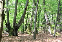
Rheingau Gebück
The Rheingau Gebück was a border fortification consisting of “bent” beeches (a so-called “ Landwehr ”) that enclosed the Rheingau for 600 years until the end of the 18th century.


Emergence
With the increasing development of the Erzmainzischen sovereignty over the Rheingau, which in the 12th century under Archbishop Adalbert I of Saarbrücken (1111–1137) can be regarded as largely complete and secure, the Rheingau combined the intensive and systematic improvement of old border fortifications.
nature
This is how the pinnacle was created , consisting of “a 50–60 m wide strip of forest of beech , oak and, above all, hornbeam . The trees were cut down at varying heights above the ground and the newly cut branches were 'bent' back and forth across the ground and interwoven. Blackberry and blackthorn bushes planted themselves in between. "
The undergrowth, up to 100 meters wide, became increasingly impermeable. Only a few reinforced gates allowed passage. The flanks were connected by a well-developed system of paths, which ensured the rapid deployment of troops. Construction, maintenance and defense were the responsibility of the men who were also militarily trained and always armed from the nearest town.
course
The pecking followed the west bank of the Walluf from Niederwalluf northwards via Oberwalluf , Neudorf (later Martinsthal ) and Tiefenthal, until it turned west in today's Schlangenbad on Warm Bach and just north of the Taunus main ridge above the outskirts of Hausen vor der Höhe and von Hof Maps led to the intersection known as Seven Signposts . Here there was a change of direction in a north-westerly direction towards the White Tower near Presberg and the Kammerburg on the Wisper . At Rheinberg Castle , the bridge went west again, further south past Hof Oders and Sauerthal , reached the border with Kaub in the Electoral Palatinate in the Niedertal and finally ended after about 40 kilometers on the Rhine north of Lorchhausen . There are also opinions that the bridge led through between Lorch and the Lorchhausen settlement that was not built until the 13th century.
Decline
With the advent of wall-breaking weapons, the importance of this form of border fortification decreased. Nevertheless, it is astonishing how effectively the Rheingau Gebück protected the landscape within it for around 600 years from its extensive completion in the 12th century. It was not until 1771 that it was given up and largely cleared after a written order from the Archbishop of Mainz, Emmerich Joseph von Breidbach zu Bürresheim (1763–1774). So today only a few, correspondingly old beeches and of the stone bulwarks only remains of the so-called Mapper Schanze in the forest above Hallgarten (Oestrich-Winkel) are preserved. It is a round gate built in its current form in 1494. It served to defend the road leading up from Stephanshausen to the northern border. It was flanked by a round tower with loopholes and a domed roof, on which sat a square pointed tower, which was used to observe the path.
Some of the other stone fortifications were still used for some time after the abandonment of the structure, but were eventually used as a source of cheap building material and almost completely removed.
In 2014, excavation work in Walluf uncovered the remains of the former oven bulwark . Part of a vault should be preserved for posterity.
Rheingau Gebück hiking trail
In 2000 the Rhein-Taunus Nature Park Association set up the Rheingau Gebück hiking trail . The hiking trail that roughly follows the course of the bridge leads past the few remaining evidence of the bridge and explains historical details about the Rheingau bridge at a total of 21 stations.
literature
- Gustav Lüster: The Rheingau Gebück. Natural monuments in Nassau 2, Wiesbaden, Bechtold 1913.
- Joachim Karl Laub: The Rheingau Gebück. In: Rheingauische Heimatblätter. Communications from the Society for Rheingau Local History Research No. 4/1968 - No. 1/1971; Rüdesheim / Rhine.
- Christian Grubert: The Rheingau Gebück hiking trail: a cultural and historical hiking guide. Idstein, Zweckverband Naturpark Rhein-Taunus 2001.
- Ingo Bildheim: The Erzmainzische Rheingau in the German Peasants' War. Unpublished typescript.
See also
Web links
Individual evidence
- ↑ Enderich, Richard: Hessische Heimat, Nassau. Issue 2. Taunus. Hirschgraben-Verlag, Frankfurt am Main 1966, p. 35f.
- ↑ Large remains of the important "fortress" Walluf discovered Rheingau-Echo on March 6, 2014
- ^ Wallufer fortress was the eastern passage of the Rheingau Gebück Norbert Michel, Herbert Ujma
Coordinates: 50 ° 4 ′ 39 ″ N , 8 ° 0 ′ 54 ″ E

