Rinkenmauer
| Rinkenmauer | ||
|---|---|---|
|
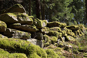
Rinkenmauer on the Rinkenkopf |
||
| Alternative name (s): | Rinkenwall | |
| Castle type : | Hilltop castle | |
| Conservation status: | Burgstall , remains of the wall | |
| Place: | Baiersbronn | |
| Geographical location | 48 ° 30 '54.6 " N , 8 ° 21' 53.2" E | |
|
|
||
The Rinkenmauer is a ring wall system on the southeastern tip of the Rinkenberg pushing forward towards the Murgtal near Baiersbronn in the Freudenstadt district ( Baden-Württemberg ).
The Wallburg could have been a fortification to protect the Reichenbach Monastery , which was founded in the late 11th century and is also known as the owner.
history
A first mention can be found around 1100 in the donation book of the Reichenbach monastery. Here a property is called “in monte qui Rincga vocatur”. With Rincga the ring wall is somewhat ring-shaped, probably meant. The donation of properties on the Rinkenberg indicates that the fortification no longer had a military or administrative function at that time.
There have been detailed descriptions since 1859. They contain various interpretations of the time of origin and use as a refuge or to protect grazing cattle. Comprehensive excavations or finds that allow dating have not yet existed. Similar fortifications were probably built before 1000.
In 2006, the archaeological investigation of a sub-area took place before the construction of a transmission tower . Traces of the extraction of material, probably for stone extraction for the construction of the wall, were found. There were no traces of permanent settlement.
description
The 115 m long and 30 to 40 m wide ring wall is located at the highest point of the ridge. The almost 27 m long north-western front side is interrupted by a narrow entrance. The remaining 240 m of fortification run along the rounded mountain peak and enclose an area of almost 0.4 hectares.
The wall consists of stacked stone blocks, of which up to five layers have been preserved. It reaches a height of up to 1.4 m on the outside. The wall thickness is 1 to 1.5 m, at the front up to 2 m. The stone blocks of different sizes have no traces of processing. Parts of the wall have been destroyed by falling or building work.
About 50 m before the entrance in the northwest, through which a hiking trail runs today, a stone bar can be seen as the remainder of a pre-fortification. There is no ditch .
literature
- Christoph Morrissey, Dieter Müller: The Rinkenmauer near Baiersbronn. In: Atlas of archaeological land monuments in Baden-Württemberg. Volume 2, Issue 19, Konrad Theiss Verlag, Stuttgart 2006, ISBN 978-3-8062-2088-9 .
Web links
Individual evidence
- ^ Entry on Rinkenberg in the private database "Alle Burgen".
- ^ Sönke Lorenz , Axel Kuhn : Baiersbronn. From the royal forest to the climatic health resort. Wegrahistorik-Verlag, Stuttgart 1992, pp. 57-58.
- ↑ Dorothee Lengert, Steffen Killinger, Claus Brenner: Archaeological finds - early traces of habitation. In: Sönke Lorenz (Ed.): The Northern Black Forest. From the wilderness to the growth region. Markstein Verlag, Filderstadt 2001, ISBN 3-935129-01-7 , pp. 30–31.
- ↑ Guntram Gassmann, Folke Damminger: Archaeological investigations in the fortified hilltop settlement on the Rinkenkopf near Baiersbronn, Freudenstadt district. In: Archaeological excavations in Baden-Württemberg 2006. Konrad Theiss Verlag, Stuttgart 2007, ISBN 978-3-8062-2093-3 , pp. 261-265.


