Rohden (Hessisch Oldendorf)
|
Rohden
City of Hessisch Oldendorf
Coordinates: 52 ° 11 ′ 38 " N , 9 ° 14 ′ 38" E
|
|
|---|---|
| Height : | 105 (101-129) m |
| Area : | 3.64 km² |
| Residents : | 699 |
| Population density : | 192 inhabitants / km² |
| Incorporation : | 1st January 1973 |
| Postal code : | 31840 |
| Area code : | 05152 |
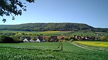
Rohden is a place in the municipality of Hessisch Oldendorf and has 699 inhabitants.
It is located in the Weserbergland Schaumburg-Hameln nature park about 4 kilometers north of Hessisch Oldendorf and 15 kilometers northwest of the district town of Hameln . State road 434 runs through Rohden .
history
Rohden was first mentioned in a document in 1015.
The place has a remarkable stone box from the Neolithic Age . There are also two manor mills belonging to the Counts of Schaumburg from the 10th century on the Rohdener Bach . The abandoned hilltop castle Burg Roden is located on a plateau of the Amelungsberg near the village .
In Rohden (Hessisch Oldendorf) a witch hunt was carried out around 1560 : Dieckmann was accused in a witch trial. She made a confession under torture and was likely cremated.
Individual evidence
- ^ Gerhard Schormann : Witches' persecution in Schaumburg , in: Niedersächsisches Jahrbuch für Landesgeschichte, Volume 45, Hildesheim 1973, pp. 149–151.

