Roden Castle
| Roden Castle | ||
|---|---|---|
|
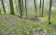
Castle plateau of the main castle |
||
| Alternative name (s): | Rohden | |
| Creation time : | around 1135 | |
| Castle type : | Hilltop castle | |
| Conservation status: | Burgstall | |
| Standing position : | Count | |
| Place: | Hessisch Oldendorf - Rohden | |
| Geographical location | 52 ° 12 '1.2 " N , 9 ° 15' 11" E | |
|
|
||
The Roden Castle , also spelled Rohden , is an abandoned hilltop castle on a plateau of the Amelungsberg ridge in the Süntel . The remains of the castle are located in the Rohden district of the municipality of Hessisch Oldendorf in the Hameln-Pyrmont district in Lower Saxony . The castle area is located in the Hohenstein nature reserve .
history
The castle was built between 1130 and 1140 by the Counts of Roden to expand their sphere of influence into the Weser Valley . At that time the counts, like the counts of Holstein-Schaumburg, were followers of Henry the Lion in his quarrel with Emperor Friedrich Barbarossa . The Schaumburg , about 4 km away, was built shortly before in around 1100. In 1181 there was an open conflict between the Schaumburgs and the Counts of Roden with the aim of expelling them from the Weser Valley. At the end of the 12th century the von Roden withdrew to the Wunstorf - Limmer area and left the castle to the Schaumburgers.
description
The castle complex consisted of a bailey and a slightly smaller main castle , which were directly adjacent to each other. The elevated plateau of the main castle, which was secured with a rampart and a moat, measures around 22 by 26 meters. A 3 to 5 meter deep ring trench secured the castle hill. The main castle was surrounded by a wall, to the west a two-part Palas a farm building were scheduled and the East. The courtyard was probably paved. The outer bailey had an area of 20 × 40 meters. Individual remnants of the wall indicate that the outer bailey was walled as security.
Later the buildings served the population as a quarry. Today Burgstall (castle point) shows only barely visible structural remains, while Wall- and grave system can still be seen.
Archaeological investigations took place in 1926, 1950 and 1958. An outer curtain wall and building walls were excavated, which were executed in Opus spicatum . The finds, such as ceramics, keys, knife parts, nails, horseshoes, game pieces, a coin (1435), indicate that the castle was in use from the 12th to 15th centuries. Written records about the castle are not known.
About 1 km away in the east is the prehistoric to medieval hill fort Amelungsburg on the Amelungsberg .
literature
- Hans-Wilhelm Heine : Schaumburger Land - Burgenland , in the series Guide to the Prehistory and Early History of Lower Saxony (29), Oldenburg, 2010, published by the Lower Saxony State Office for Monument Preservation and the Archaeological Commission for Lower Saxony , ISBN 978-3-89995-673- 3
Web links
- Entry by Stefan Eismann on Roden Castle in the scientific database " EBIDAT " of the European Castle Institute
- Description of Roden Castle at landes-zeitung.de


