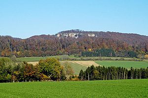
Hohenstein (nature reserve)
|
Hohenstein
|
||
| location | Northeast of Hessisch Oldendorf , Hameln-Pyrmont district , Lower Saxony | |
| surface | 877 ha | |
| Identifier | NSG HA 002 | |
| WDPA ID | 4391 | |
| Geographical location | 52 ° 12 ' N , 9 ° 19' E | |
|
|
||
| Sea level | from 138 m to 350 m | |
| Setup date | July 12, 1952 | |
| administration | NLWKN | |
Hohenstein is the name for the Hohenstein mountain in the Süntel and the Hohenstein nature reserve named after the mountain in the Lower Saxony town of Hessisch Oldendorf in the Hameln-Pyrmont district .
Nature reserve


The nature reserve with the registration number NSG HA 002 is 877 hectares in size. It is almost completely part of the FFH area “Süntel, Wesergebirge, Deister” and completely part of the EU bird sanctuary “Eagle owl breeding grounds in the Weser Uplands”. The “Hohenstein” natural forest reserve, designated in 1972, and the 22.4 hectare “Schrabstein” natural forest reserve, designated in 1974, are part of the nature reserve.
The nature reserve is located within the Weserbergland Schaumburg-Hameln nature park in the northwest of the Süntel and northeast of Hessisch Oldendorf. In this area, it places the limestone and beech forest area in the high elevations of the Süntel and in the transition to the Weser Mountains under protection. There are several striking rock formations in the nature reserve , especially on the Hohenstein, the Südwehe, the Iberg and Schrabstein and on the Amelungsberg.
The reserve is mostly of relief rich , mesophilic forests in whose Krautschicht numerous orchids occur, embossed with some deep stream valleys. Tufa springs can be found along the lime-rich, fast-flowing brooks, which are accompanied by alluvial forests . There are only isolated grassland areas along the streams. The cuesta combs with rock outcrops of coral oolite have Kalkfelsfluren and natural caves on.
In Langenfeld, a district of Hessisch Oldendorf, the Langenfeld waterfall, which is a designated natural monument , is located on the edge of the nature reserve . The 15 meter high waterfall of the Höllenbach is the highest natural waterfall in Lower Saxony.
A little south of Langenfeld, the nature reserve borders a limestone quarry , on the northern edge of which is the Schillat Cave . In the west of the quarry, in which oolithic limestone has been extracted since 1902 , there is another natural monument at the edge of the nature reserve with the Riesenberghöhle, a stalactite cave and, with a length of 800 meters, the largest cave in Lower Saxony. With the Iborn spring and the beech in the snow, there are two other natural monuments in the north-west of the nature reserve.
In the northeast of the nature reserve north of the Hohenstein on the upper reaches of the Blutbach there is a forest lake that was created in early 1932 by a landslide .
The area, which is looked after by NABU Hessisch Oldendorf , has been under nature protection since July 12, 1952. It replaces the nature reserve of the same name that was designated on March 2, 1930. The responsible lower nature conservation authority is the district of Hameln-Pyrmont.
The forest in the NSG is used intensively for forestry by the Oldendorf Forestry Office. In March 2013, the use of a 13.4 t forest hauler caused severe devastation on the Wendgeberg.
Web links
- Nature reserve "Hohenstein" in the database of the Lower Saxony State Office for Water Management, Coastal and Nature Conservation (NLWKN)
- The Weser and the Ice Age - landscape history between water and ice , description of geological development with maps and drawings, State Office for Mining, Energy and Geology in Lower Saxony (PDF; 267.4 kB)
Individual evidence
- ↑ Profile of the Hohenstein natural forest , database of natural forest reserves in Germany, Federal Agency for Agriculture and Food . Retrieved March 28, 2012.
- ^ Profile of the Schrabstein natural forest , database of natural forest reserves in Germany, Federal Agency for Agriculture and Food. Retrieved March 28, 2012.
- ↑ a b c Landscape cadastre , Hameln-Pyrmont district (PDF, 6.1 MB). Retrieved April 18, 2018.
- ↑ To rock gaps and Süntelbuchen am Hohenstein , Geolife - The leisure portal in Lower Saxony. Retrieved April 18, 2018.
- ↑ Schneegrundweg , Geolife - The leisure portal in Lower Saxony. Retrieved April 18, 2018.
- ^ Hohenstein nature reserve , NABU Lower Saxony. Retrieved on March 28, 2012. ( Memento of February 16, 2012 in the Internet Archive )
- ↑ Nature conservation in wood chopping style , DEWEZET of March 22, 2013, accessed on April 8, 2013


