Hohenstein (Süntel)
| Hohenstein | ||
|---|---|---|
|
The Hohenstein |
||
| height | 340.5 m above sea level NHN | |
| location | between Bensen and Langenfeld ; Hameln-Pyrmont district , Lower Saxony ( Germany ) | |
| Mountains | Süntel , Weser Uplands | |
| Dominance | 1 km | |
| Notch height | 11 m | |
| Coordinates | 52 ° 11 '58 " N , 9 ° 19' 17" E | |
|
|
||
| particularities | Climbing area | |
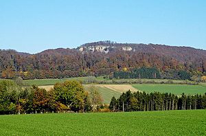
The Hohenstein is 340.5 m above sea level. NHN high mountain in the west of the Süntels belonging to the Weserbergland . It lies between Bensen and Langenfeld in the Hameln-Pyrmont district in Lower Saxony . There is a climbing area on the mountain .
geography
location
The Hohenstein rises in the Weserbergland Schaumburg-Hameln Nature Park . Its peak is in the urban area of Hessisch Oldendorf 2.7 km northeast of Zersen , 2.9 km north-northeast of Wickbolsen , 2.8 km north of Bensen and 2.4 km southeast of Langenfeld . Past the continuously wooded mountain, the Blutbach flow in the north and west and the Langeföhrbach in the south , both of which arise in the east and merge south-southwest of the mountain to form the Hollenbach .
Natural allocation
The Hohenstein belongs in the natural spatial main unit group Weser-Leine-Bergland (No. 37), in the main unit Calenberger Bergland (378) and in the subunit Weserberge (378.1) to the natural area Weser Mountains (378.10). To the north-west, the landscape turns into the natural area Northwest-Süntel (378.12) and to the north-east into the natural area Südost-Süntel (378.13). In the south there is the natural area Steinbergener Loesshang (366.11), which belongs to the main unit group Upper Weserbergland (36) and the main unit Rinteln-Hamelner Weserland (366) to the subunit southern Wesergebirgsvorland (366.1).
Protected areas
Parts of the Hohenstein nature reserve are located on the Hohenstein ( CDDA no. 4391; designated 1952; 877 hectares in size). Except for its eastern part, parts of the landscape protection area (LSG) Süntel (CDDA no. 324964; 1968; 28.789 km² ) and at the transition there to the Brennenberg those of the LSG Hessisch Oldendorfer Wesertal / North (CDDA no. 321590; 1983; 27.878 km²). On the mountain are parts of the fauna-flora-habitat area Süntel, Weser Mountains , Deister (FFH no. 3720-301; 24.97 km²) and the bird sanctuary for eagle owl breeding grounds in the Weserbergland (VSG no. 3720-431; 10.06 km²).
Landscape and geology
The Hohenstein has a high plateau that drops steeply about 40 m on the southern edge. The cliffs made of coral oolite can be seen far out of the Upper Weser Valley . The rock faces and rocks of the mountain include: Eibenwand , Grüner Altar , Hirschsprung , Kreuzstein and Teufelskanzel .
Climbing area
The Hohenstein is a popular climbing area . At the end of the 1960s, a climbing ban was imposed for reasons of protection, but this was later lifted with certain restrictions. However, certain rocks are still prohibited from climbing all year round, while other routes are closed in winter from October 1st to March 15th to protect them from bats.
gallery
literature
- Ernst Andreas Friedrich : The Green Altar on the Hohenstein , P. 74-77, in: If stones could talk. Volume I, Landbuch-Verlag, Hannover 1989, ISBN 3-7842-03973 .
Web links
- The Weser and the Ice Age - landscape history between water and ice , description of geological development with maps and drawings, State Office for Mining, Energy and Geology in Lower Saxony (PDF; 267.4 kB)
- Photograph of the Hohenstein from 1951 , on kulturerbe.niedersachsen.de
Individual evidence
- ↑ a b c Map services of the Federal Agency for Nature Conservation ( information )
- ↑ Hohenstein Eibenwand - Süntel , DAV Felsinfo , on alpenverein.de
- ↑ Hohenstein im Süntel is winter quarters for bats , article from November 4, 2002, IG Klettern Niedersachsen eV, on ig-klettern-niedersachsen.de


