Royston (Hertfordshire)
| Royston | ||
|---|---|---|
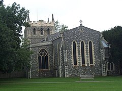
| St John the Baptist Church, Royston | ||
| Coordinates | 52 ° 3 ′ N , 0 ° 1 ′ W | |
| OS National Grid | TL357406 | |
|
|
||
| Residents | 15,781 (as of 2011) | |
| administration | ||
| Post town | ROYSTON | |
| ZIP code section | SG8 | |
| prefix | 01763 | |
| Part of the country | England | |
| region | East of England | |
| Shire county | Hertfordshire | |
| District | North Hertfordshire | |
| Civil Parish | Royston | |
| British Parliament | North East Hertfordshire | |
Royston is a city and a management unit in the District North Hertfordshire in the county of Hertfordshire , England. Royston is 17 miles from Hertford . In 2011, it had a population of 15,781.
The city is on Roman Ermine Street . Roman remains were found; there are also several barrows and earth walls on the neighboring hills. A monastery of the Augustinian Canons was founded towards the end of the 12th century, but nothing of the building remained. In 1742, a hermit cave carved from the lime under a street in the city was discovered, the walls of which show crude depictions of crucifixions and other sacred subjects.
Royston has a 13th-century Gothic church that was restored in 1872, as well as the remains of a hunting lodge built by James I in 1607 .
Town twinning
Royston has the following city partnerships :
- Großalmerode , Hessen , Germany (since 1974)
- La Loupe , Eure-et-Loir department , France (since 1986)
- Villanueva de la Cañada , Comunidad de Madrid , Spain (since 2011)
Web links
- Parishes Royston , in: A History of the County of Hertford , Vol. 3, London 1912, pp. 253-265, British History Online.
Individual evidence
- ↑ GENUKI: Distance from ROYSTON [TL357406 ] ( English ) Retrieved on April 3, 2017th
- ↑ Office for National Statistics: Area: Royston (Parish) ( English ) Neighborhood Statistics. Retrieved April 3, 2017.
- ^ Royston , Encyclopædia Britannica , 11th edition, 1910-11, Vol. 23, p. 795.
- ^ Royston, Hertfordshire . In: Meyers Großes Konversations-Lexikon . 6th edition. Volume 17, Bibliographical Institute, Leipzig / Vienna 1909, p. 205 .
- ↑ Royston & District Twinning Association (English)

