Sabotsy Namehana
| Sabotsy Namehana | ||
|---|---|---|
|
|
||
| Coordinates | 18 ° 50 ′ 9 ″ S , 47 ° 33 ′ 20 ″ E | |
| Basic data | ||
| Country | Madagascar | |
| Antananarivo | ||
| region | Analamanga | |
| ISO 3166-2 | MG-T | |
| District | Antananarivo-Avaradrano | |
| height | 1250 m | |
| surface | 22 km² | |
| Residents | 63,660 (2001) | |
| density | 2,893.6 Ew. / km² | |
| Post Code | 103 | |
| Website | sabotsy-namehana.com (French) | |
|
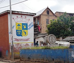
The town's coat of arms on a house wall at the entrance to the town
|
||
Sabotsy Namehana is a place in the central highlands of Madagascar , which together with the surrounding villages forms the rural commune of the same name ( Commune rural ) with an area of 22 km². The place is located in the Analamanga region , about 10 km north of the capital Antananarivo .
geography
The place is located on the north bank of the Mamba River on a ridge running in northwest-southeast direction at about 1250 meters above sea level. On both sides of the ridge there are extensive plains that are used for growing rice. A connecting road to Ambohimanga , the old royal seat of the Merina, runs across the ridge . Originally the place was only named Namehana , after one of the Twelve Sacred Hills of the Merina Kingdom . King Andrianampoinimerina settled Rabodo, one of his wives, on the hill around 1810. The addition Sabotsy means "Saturday" and refers to the weekly market that takes place there on Saturdays.
The place has been devastated by cyclones at irregular intervals, the last time on February 14, 2012 by Giovanna .
Population and economy
Most of the population belongs to the Merina tribe ( Foko ) . The last census in 2001 counted 50,100 inhabitants, meanwhile the population has risen to 63,660 (as of 2017). The main occupations are arable farming (70%) and fishing (10%). There is also a small craft sector (5%) and service providers (15%). The main crops are rice and vegetables, especially kale .
Infrastructure
The place is connected to the capital via the asphalt national road 3 , whose public bus lines extend into the place. To the north, the national road connects the place with the district capital Anjozorobe, 80 km away . There is a post office (post code 103), a hospital, a branch of the Bank of Africa , a fire department and several secondary and primary schools. The place is connected to the public electricity and water network. In the center of the village there is a market where groceries are offered daily; On Saturdays, the market extends to around 2 hectares of the surrounding squares and streets and also offers textiles and everyday items.
Personalities
- Hery Rajaonarimampianina (* 1958), Malagasy politician
Web links
- Website of the municipality ( French ), accessed on October 23, 2017
Individual evidence
- ↑ a b basic data of the municipality. Commune Rurale Sabotsy Namehana, accessed October 23, 2017 (French).
- ↑ Carte de Madagascar au 1 / 100,000 Feuille P. 47 Antananarivo, FTM 1978
- ↑ Imerina - the 12 holy hills ( memento of the original from March 11, 2014 in the Internet Archive ) Info: The archive link was automatically inserted and not yet checked. Please check the original and archive link according to the instructions and then remove this notice. , accessed March 11, 2014
- ↑ Pictures of the floods of February 14, 2012 , accessed on March 11, 2014
- ^ Census 2001. (Excel) Cornell University , December 31, 2001, accessed December 29, 2010 (French, 2.4 MB).

