Cyclone season in the Southwest Indicator 2011–2012
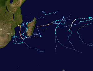
All the storms of the season
|
Formation of the
first storm |
5th December 2011 |
Dissolution of the
last storm |
June 7, 2012 |
| Strongest storm |
Giovanna - 932 hPa ( mbar ), 100 kn (185 km / h ) (10 minutes)
|
| Trop. Disruptions |
14th |
| Tropical lows |
14th |
| Number of cyclones |
10 |
| Number of cyclones |
3 |
| Total number of victims |
164 total |
| Total damage |
~ Unknown |
Südwestindik cyclone seasons
2009–10 , 2010–11 , 2011–2012 , 2012–13 , 2013–14
|
The cyclone season in the 2011–2012 Southwest Indica officially began on November 15, 2011 and ends on April 30, 2012, with the exception of Mauritius and the Seychelles , where it does not end until May 15, 2012. These dates conventionally limit the time of the meteorological year of the southern hemisphere during which most tropical cyclones form in the southwestern Ind . The first tropical system formed on December 5, 2011.
The tropical cyclones in this basin are monitored by the Regional Specialized Meteorological Center (RSMC) in Reunion Island , France . Météo-France's area of responsibility includes the Indian Ocean south of the equator and west of 90 ° east longitude . Tropical cyclones in this area are called cyclones. The Joint Typhoon Warning Center (JTWC) in Honolulu also monitors the weather in this sea area; it issues storm warnings primarily aimed at United States Armed Forces facilities in the Indian Ocean.
Storms
Severe Tropical Storm Alenga
On December 5th, a rapidly developing low pressure area crossed 90 ° east longitude and came under the responsibility of Météo-France in La Réunion. Just a few hours later, the Joint Typhoon Warning Center (JTWC) classified the system as a tropical storm and named it 01S . Band structures were visible on the satellite images at this point in time. Favorable atmospheric conditions allowed an increase in convection in the area of the center, as well as good outflow . A few hours later in La Réunion, the RSMC found that the system had intensified into a moderate tropical storm and the system was named Alenga by the Mauritius Meteorological Service. Alenge intensified rapidly and reached the strength of a severe tropical storm during the day. Although the prognoses assumed an intensification into a tropical cyclone, Alenga weakened around noon on December 6th and was downgraded to a moderate tropical storm. In the course of December 6th, Alenga also made a sharp left turn and early on December 7th began to move about 550 nautical miles west of the Cocos Islands to the southeast. It reached the 90th east longitude on December 7 at 7:00 a.m. UTC and thus left the basin.
Tropical Depression 02
| Tropical Depression ( MFR )
|
| Tropical storm
|
|
|
| Duration
|
December 6th - December 16th
|
| intensity
|
30 kn (55 km / h ) (10 minutes) , 998 hPa
|
On December 6, 2011, Météo-France classified a tropical disruption between Reunion Island and Diego Garcia as a Tropical Depression. The next day, the system entered an area with strong vertical wind shear , exposing the surface circulation center and soon collapsing into a residual depth, but early on December 8th the system regenerated into a weak tropical depression. During the day, convection again developed around the circulation center, even as the westward moving system slowly lost its intensity. Météo-France issued its final warnings on the system on December 9th because it was too weak to remain classified as a tropical depression. The remaining low moved across the southwest Indian Ocean until it was completely dissolved on December 16.
Subtropical Depression 03
| Subtropical Depression ( SSHWS )
|
|
|
| Duration
|
December 19 - December 23
|
| intensity
|
30 kn (55 km / h ) (10 minutes) , 1000 hPa
|
A low pressure area on the southeast coast of Madagascar was classified as a subtropical depression by Météo-France on December 19. The system barely moved until December 20th. On December 21st it moved very slowly south and began to weaken. The RSMC issued its final warning on the disintegrating system on December 23.
Tropical cyclone Benilde
On December 28, RSMC La Réunion announced that the fourth tropical disturbance of the season had moved over from the Australian region; it had moved there for about a week, first in a southerly and then in a westerly direction through the southeastern Indic . During the course of the day, the disturbance developed steadily, so that the JTWC began issuing warnings for 02S . Météo-France classified the system as a moderate tropical storm on December 29, and by the Mauritius Meteorological Agency the storm was named Benilde , which was proposed by Mozambique.
Benilde continued to move roughly westward and intensified rapidly until it was classified as a tropical cyclone on December 31st. Then the storm swung southwest and intensification continued until drier air entered the southern areas of the storm on January 1. The convection increased for a short time, but the RSMC found, after reaching the peak with sustained wind speeds of 150 km / h later that day, that the eyewall on the north side of the eye collapsed. On January 3, Benilde weakened into a severe tropical storm. Strong wind shear contributed to further weakening the system, which on January 4th was just a tropical depression. This absorbed a weak disturbance north of the system late that day, but Benilde weakened further early on January 5th. The northern areas of the system completely disintegrated and the convection shifted south of the storm center while the system lost its tropical properties.
Moderate tropical storm Chanda
| Moderate tropical storm ( MFR )
|
| Tropical storm
|
|
|
| Duration
|
January 8th - January 11th
|
| intensity
|
35 kn (65 km / h ) (10 minutes) , 996 hPa
|
On January 4, Météo-France found that embedded in the intertropical convergence zone in the area of the Mozambique Strait , strong convective activity developed and a low-level circulation formed near the coast of Mozambique . This disturbed weather zone persisted for the next few days, and on the morning of January 8, Météo-France announced that a tropical disturbance had formed. Six hours later, the system was upgraded to a tropical depression. This moved southeast towards Morondava on the west coast of Madagascar. Another six hours later, the system was classified as a moderate tropical storm and was given the Mauritius-proposed name Chanda . After making landfall late on January 8th, Chanda began to weaken. The storm then moved overland to the south of the island and finally reached southeast Madagascar on January 10th across the Indian Ocean. Chanda intensified slightly above water, but wind shear then weakened it. The structure of the storm in the northern semicircle collapsed early on January 11, and the system became an extra-tropical system.
Chanda generated heavy rainfall over Madagascar, so that around 280 mm of precipitation was recorded within 48 hours. Floods and floods cut off several localities from the outside world, and numerous houses were flooded. In Miandrivazo , at least one person drowned in the floods.
Subtropical Depression Dando
| Subtropical Depression ( MFR )
|
|
|
| Duration
|
January 11th - January 16th
|
| intensity
|
45 kn (85 km / h ) (10 minutes) , 990 hPa
|
A nontropical fault formed east of Madagascar on January 11th, which transformed into a subtropical depression the following day under the influence of the disintegrating storm Chanda. While the system retained subtropical features as it migrated towards mainland Africa , it developed sufficient wind speeds on January 15 that meteorologists in Madagascar assigned the name Dando, which had been proposed by Tanzania . On January 16, the RSMC issued the last warning for the system, which has now weakened to the residual low. This residual low moved across the mainland on January 17th, where Dando completely dissolved on January 18th.
Dando was the first tropical or subtropical storm since Tropical Storm Domoina in 1984, which hit southern Mozambique. Heavy rains over the south of the country caused significant flooding, so the authorities asked residents of flood-prone areas to evacuate. Waves up to six meters high were observed on the coast, preventing fishermen from going out. Rainfall caused by the storm also affected parts of Zimbabwe and Swaziland . Hundreds of tourists in the Kruger National Park in South Africa were partially cut off and at least 30 people had to be flown out because flash floods washed away bridges and damaged numerous buildings and roads. Dando caused at least ten deaths, including six people who drowned in the South African province of Mpumalanga after the Olifants River overflowed .
Severe tropical storm Ethel
| Severe Tropical Storm ( MFR )
|
| Category 1 cyclone
|
|
|
| Duration
|
January 18 - January 23
|
| intensity
|
55 kn (100 km / h ) (10 minutes) , 985 hPa
|
On January 18, RSMC La Réunion began monitoring a tropical disturbance that had developed northeast of Rodrigues . On that day the system developed steadily better and was named Ethel by the Mauritius Meteorological Service after reaching the status of a tropical storm. Ethel intensified into a severe tropical storm late January 19th. The next day Ethel reached a strength equivalent to Category 1 on the Saffir-Simpson hurricane wind scale , but cool water and wind shear , which was unfavorable for further development, prevented Ethel from intensifying. On January 22nd, Ethel was downgraded to a moderate tropical storm. The convection shifted to the south side of the center, which lost its tropical properties on January 23.
As Ethel passed Rodrigues, high winds and heavy rain were recorded on the island with a rainfall of 174 mm in 24 hours. There was significant property damage and communications disruptions on the island. One person died of an electric shock in an incident caused by the storm .
Intense Tropical Cyclone Funso
| Intense Tropical Cyclone ( MFR )
|
| Category 4 cyclone
|
|
|
| Duration
|
January 19 - January 28
|
| intensity
|
105 kn (195 km / h ) (10 minutes) , 936 hPa
|
On January 17, the RSMC and JTWC began observing a low pressure area that had formed about 620 km northwest of Antananarivo , Madagascar in the Mozambique Strait . In the course of the following two days, the system rapidly intensified due to favorable conditions. Early on January 19, the RSMC declared the System to be Tropical Depression 08, and shortly thereafter the JTWC found that the system developed one-minute wind speeds of a tropical storm and classified the system as Tropical Cyclone 08S . The system was eventually upgraded to a tropical storm by the RSMC and was named Funso. On January 20th, Météo-France Funso upgraded to a tropical cyclone. The cyclone was approaching the coast of Mozambique, but stayed afloat and turned south on a clockwise loop. The proximity to the mainland, where around three million people were exposed to winds the strength of a tropical storm, caused a slight weakening on January 22nd and 23rd, but when Funso moved away from the mainland, the cyclone regained its strength. On January 24th, Funso intensified a little more and continued its south-southeast hike. A new eyewall formation on January 25 led to a temporary weakening of the cyclone, but a few hours later Météo-France Funso classified again as an intense tropical cyclone at noon that day. This intensification was followed in the course of the day by another new eyewall formation, which resulted in the formation of an even larger eye with a diameter of 55 km.
Numerous people died on land and at sea as a result of the effects of the cyclone. On the night of January 18, a ship en route from Anjouan to Mayotte with 54 people on board sank in the rough seas created by the developing storm. At least 15 of them drowned and dozens went missing.
As of January 24, the Mozambican authorities had recorded 25 deaths from cyclone Funso, most of them in the northern province of Zambezia , off whose coast the cyclone had made its closest approach to the mainland. At least seven of the victims were in the Maganja da Costa district and another in the provincial capital, Quelimane . The only road link between the capital Maputo and the north of the country was badly damaged by the flooding Komati River . More than 56,000 residents of the country had to flee from floods, at least 70,000 people lost the supply of clean drinking water .
The storm also had an impact in Malawi , where 450 families were left homeless in the southern part of the Nsanje district , mainly in Bangula and Phokela. Heavy rain destroyed at least 320 houses and flooded 125 more. The floods destroyed the harvest, putting the affected localities at risk of famine.
Intense Tropical Cyclone Giovanna
| Intense Tropical Cyclone ( MFR )
|
| Category 4 cyclone
|
|
|
| Duration
|
February 9th - February 20th
|
| intensity
|
100 kn (185 km / h ) (10 minutes) , 932 hPa
|
A tropical disruption that formed in the southern Indian Ocean on February 7th intensified and was classified as Tropical Depression 09 by RSMC La Réunion on February 9, south-southwest of Diego Garcia . The system intensified into a tropical storm that same day and was designated the 12S by the JTWC . The system continued to gain strength and a few hours later the storm intensified into a moderate tropical storm and was named Giovanna . On February 10th, the intensification trend continued and Giovanna stepped into a severe tropical storm. During the day, Giovanna underwent an explosive intensification into an intense tropical cyclone, equivalent to category 4 on the Saffir-Simpson wind scale . Cyclical new eyewall formation soon set in, turning the storm into a tropical cyclone on February 11th. However, the wind shear around Giovanna decreased, so on February 13th Giovanna intensified herself again into an intense tropical cyclone with one bigger eye . At around 10:00 p.m. UTC on February 13th, Giovanna landed at Andovoranto in Madagascar . There the system weakened very quickly on February 14th into an overland depression. Early on February 15, Giovanna reached the west coast of the island and entered the Mozambique Strait, where the storm began to reorganize. It also happened while the storm was moving east, before Giovanna took a sharp turn to the left and threatened to cross the country again. But this did not happen because the storm was previously extra-tropical.
Waves up to eight meters high hit the coast of La Réunion, where a man was caught by the breakers and washed out to sea. A man was killed in a weather-related traffic accident in Mauritius. At least 16 people were killed in Madagascar by the effects of the storm and 65 others injured. About 11,000 residents of the island were left homeless.
Moderate Tropical Storm Hilwa
| Moderate tropical storm ( MFR )
|
| Tropical storm
|
|
|
| Duration
|
February 14 (from the Australian region) - February 22
|
| intensity
|
40 kn (75 km / h ) (10 minutes) , 993 hPa
|
On February 5, 2012, a small strip of thunderstorms formed in the southeast Indian Ocean off the south coast of Java , which eventually formed a low pressure area west of the Cocos Islands and quickly moved west. On the same day, the TCWC in Perth classified the low pressure area as a tropical low. The system moved further west, becoming increasingly organized. On February 14th, the system crossed the 90th east longitude and entered the southwest Indian Ocean. The RSMC La Réunion then classified the system east-southeast of Diego Garcia as a tropical depression. The system was already classified as Tropical Storm 13S by the JTWC at this stage . The system moved further west, but lost some of its power from February 15. On February 17th the system was reorganized. The system intensified further up to February 20 and only slowly gained geographical latitude on its further west-facing orbit . On February 20 at 6:00 p.m. UTC, Météo-France classified the system as a moderate tropical storm, and the storm was named Hilwa . Hilwa turned south during the day, but wind shear weakened the system again. By late February 22nd, the structure of the was completely sheared and the storm quickly turned into a non-tropical system. This development was completed on February 23 at 00:00 UTC, and a few hours later Météo-France issued the final warning about the system.
Severe tropical storm Irina
| Severe Tropical Storm ( MFR )
|
| Tropical storm
|
|
|
| Duration
|
February 26th - March 10th
|
| intensity
|
50 kn (95 km / h ) (10 minutes) , 979 hPa
|
On February 22nd, an area of disturbed weather formed in the southwestern Indian Ocean, which became a low pressure area due to favorable conditions and strong convection surrounding the center of circulation, and a tropical depression developed on February 25th. The eleventh system of the season was upgraded to a moderate tropical storm by the RSMC on February 26 and was named Irina . But just a few hours later, Irina arrived overland in northern Madagascar and within a few hours weakened into a depression overland. Early on February 28, Irina surfaced again in the northwest of the island and began to reorganize, but a second landfall delayed this intensification until the system reached the Mozambique Strait. However, the poor organization of the system in this phase initially hindered the re-intensification in a moderate tropical storm, especially since the circulation near the ground was shifted a good distance west of the convection. Irina turned on a southern orbit along the west coast of Madagascar and slowly intensified. Then the storm moved west again and approached the coast of Mozambique. Early on February 29, Irina was able to reorganize enough to be reclassified as a moderate tropical storm, and a few hours later the JTWC first classified the storm as Tropical Cyclone 12S . However, before reaching mainland Africa, the storm swung south. Late on March 1, Irina finally achieved severe tropical storm status. A few hours later, Irina changed direction again and drifted east for two days.
Tropical Depression 12
| Tropical Depression ( MFR )
|
| Tropical storm
|
|
|
| Duration
|
February 29th - March 3rd
|
| intensity
|
30 kn (55 km / h ) (10 minutes) , 996 hPa
|
On February 22nd, a monsoon trough associated with a small depression formed in a region in the central southern Indian Ocean. During the following days, the system slowly drifted westward, steadily organizing itself. Early on February 29th, the RSMC La Réunion upgraded the system, which had since taken a southbound trajectory, as a tropical disorder and six hours later to a tropical depression. Late on February 29th, the JTWC classified the system as Tropical Cyclone 15S . A few hours later, the system began to weaken as wind shear increased in the area. On March 3, the system did a cyclonic loop and then turned east. Late that day, the system weakened to a residual low, which shortly thereafter became extra-tropical.
Heavy tropical storm Koji – Joni
| Severe Tropical Storm ( MFR )
|
| Category 1 cyclone
|
|
|
| Duration
|
March 8 (from the Australian region) - March 12
|
| intensity
|
55 kn (100 km / h ) (10 minutes) , 980 hPa
|
A thunderstorm zone, which the TCWC Perth has been monitoring since March 3rd, developed to tropical low 15U on March 6th . It was identified as Tropical Cyclone 16S by the JTWC a few hours later . On the morning of March 8th, the low intensified into a Category 1 cyclone and was named Koji . A few hours later, Koji crossed the 90th east longitude to the west and was therefore renamed Joni by the Mauritius Meteorological Service. Joni organized himself over the next few days, but on March 11th, wind shear began to erode the outer convection bands. On March 12, strong wind shear completely dissolved the convection on the north side and shifted the remaining convection southeast of the center, so that the circulation center near the ground was completely exposed. As a result, Joni quickly weakened. Late that day, the RSMC Réunion issued its final warning on Koji – Joni because the storm had weakened into a non-tropical low pressure area.
Severe tropical storm Kuena
| Severe Tropical Storm ( MFR )
|
| Tropical storm
|
|
|
| Duration
|
June 5th - June 7th
|
| intensity
|
50 kn (95 km / h ) (10 minutes) , 990 hPa
|
On June 1, a tropical wave formed in the Southwest Indian Ocean, which became a tropical fault on June 5. At that time, the fault was 640 km from the Agalega Islands . It later became a tropical depression. On June 6th, it was named Tropical Cyclone 20S by the JTWC . Shortly thereafter, 20S intensified into a moderate tropical storm and was named Kuena . Later that day, Kuena even made reinforcements for a severe tropical storm. On June 7th, Kuena dissolved as quickly as it had formed.
Time overview of the season
Storm names
Tropical cyclones are given a name in this basin, provided they are at least as strong as a moderate tropical storm. When a system reaches this strength west of 55 ° east longitude, the name is assigned by the Sub-Regional Tropical Cyclone Advisory Center in Madagascar ; If the storm reaches this strength between 55 ° and 90 ° east longitude, the Regional Tropical Cyclone Advisory Center in Mauritius is responsible for the naming. The list of names for the cyclone season in the Southwest Indica 2011–2012 was announced by Météo-France in August 2009. For the last time during this cyclone season, the rule applies that storms coming in from the Australian region are given a new name through Mauritius. Storms that move from the southwest of the Indic into the area of responsibility of the Bureau of Meteorology in Perth , keep the name given in the southwest of the Indic. New lists of names are issued each year, so no names are removed from the list of tropical cyclone names.
- Alenga
- Benilde
- Chanda
- Dando
- Ethel
- Fun so
- Giovanna
- Hilwa
- Irina
|
- Joni
- Kuena
- Lesego (unused)
- Michel (unused)
- Noyana (unused)
- Olivier (unused)
- Pokera (unused)
- Quincy (unused)
- Rebaone (unused)
|
- Salama (unused)
- Tristan (unused)
- Ursula (unused)
- Violet (unused)
- Wilson (unused)
- Xavier (unused)
- Yekela (unused)
- Zania (unused)
|
See also
Web links
Individual evidence
-
↑ Tropical Cyclone 01S Advisory Number 001 ( English ) In: Joint Typhoon Warning Center . United States Navy. December 5, 2011. Archived from the original on December 5, 2011. Retrieved on December 5, 2011.
-
↑ Moderate Tropical Storm Alenga Advisory One ( English ) Reunion Island. December 5, 2011. Archived from the original on December 5, 2011. Retrieved on December 5, 2011.
-
↑ Severe Tropical Storm Advisory Alenga Two ( English ) Météo-France La Réunion. December 5, 2011. Archived from the original on December 5, 2011. Retrieved on December 5, 2011.
-
↑ Moderate Tropical Storm Alenga Advisory Seven ( English ) Reunion Island. December 6, 2011. Archived from the original on December 6, 2011. Retrieved on December 6, 2011.
-
↑ Tropical Cyclone 01S (Alenga) Warning Nr 005 ( English ) Joint Typhoon Warning Center . December 7, 2011. Archived from the original on December 7, 2011. Retrieved on December 7, 2011.
-
↑ Subtropical Depression 03 Advisory One ( English ) La Réunion. December 19, 2011. Archived from the original on December 20, 2011. Retrieved on December 21, 2011.
-
↑ Tropical Storm Chanda Drenches Madagascar ( English ) Earthweek. January 13, 2012. Retrieved January 25, 2012.
-
^ A b c Regional Association I Tropical Cyclone Committee: Tropical Cyclone Operational Plan for the South-West Indian Ocean ( English , PDF; 870 kB) World Meteorological Organization . 2010. Retrieved December 6, 2011.
-
^ Tropical Storm Dando Hits Mozambique ( English ) OurAmazingPlanet.com. January 16, 2012. Retrieved January 21, 2012.
-
↑ Mozambicans urged to leave flood-prone areas as heavy rains fall ( English ) AP. January 17th, 2012. Archived from the original on June 11th, 2016. Info: The archive link was inserted automatically and has not yet been checked. Please check the original and archive link according to the instructions and then remove this notice. Retrieved May 23, 2016.
 @1@ 2Template: Webachiv / IABot / finance.yahoo.com
-
↑ http://www.times.co.sz/News/36747.html
-
↑ http://www.thecultureist.com/2012/01/24/floods-continue-to-devastate-mozambique-as-south-africas-kruger-national-park-recovers-video/
-
↑ http://www.globalpost.com/dispatch/news/regions/africa/120119/mozambique-tropical-storm-dando-floods-maputo
-
↑ http://www.timeslive.co.za/local/2012/01/23/six-killed-in-mpumalanga-floods
-
^ Mozambique: Floods, storms kill 22 and cut off Maputo (English) , Global Post. January 23, 2012. Retrieved January 25, 2012.
-
↑ http://actualite.lachainemeteo.com/actualite-meteo/2012-01-22-00h33/le-mozambique-frappe-par-le-cyclone-funso-15319.php
-
^ Agence France-Presse: Tropical storm kills one on Indian Ocean island ( English ) Emirates 24/7. January 21, 2012. Retrieved January 25, 2012.
-
↑ Automatic impact report (JRC) FUNSO-12 in SWIndian . In: Newsroom America GDACS Daily Newsletter , January 24, 2012. Archived from the original on May 4, 2014 Info: The archive link has been inserted automatically and has not yet been checked. Please check the original and archive link according to the instructions and then remove this notice. . Retrieved January 25, 2012. @1@ 2Template: Webachiv / IABot / www.newsroomamerica.com
-
↑ Intense Tropical Cyclone 8 (Funso) Warning Number 31 ( English ) Météo-France. January 25, 2012. Archived from the original on January 25, 2012. Retrieved on January 25, 2012.
-
↑ Intense Tropical Cyclone 8 (Funso) Warning Number 32 ( English ) Météo-France. January 25, 2012. Archived from the original on January 25, 2012. Retrieved on January 25, 2012.
-
↑ http://www.linfo.re/-Faits-divers,372-/Le-naufrage-d-un-kwassa-kwassa-fait-15-morts-a-Anjouan
-
^ Death toll 25, thousands homeless in Mozambique floods (English) , Alertnet. January 25, 2012. Archived from the original on March 14, 2013. Retrieved on January 24, 2012.
-
↑ Cyclone Funso kills 12 in Mozambique (English) . In: Times Live , January 23, 2012. Retrieved January 25, 2012.
-
↑ Malawi faces Cyclone Funso as floods displace 450 families (English) . In: Nyasa Times , January 23, 2012.
-
↑ Tropical Cyclone 14S (Irina) Warning Nr 001 ( Memento from February 29, 2012 on WebCite )
-
↑ Bulletin for Cyclonic Activity and Significant Tropical Weather in the Southwest Indian Ocean - Date: 2012/02/23 at 1200 UTC ( Memento of February 23, 2012 on WebCite )
-
↑ Securite Warning for Metarea VIII (S) Issued by Meteo-France / Tropical Cyclone Center / La Reunion 03/03/2012 at 0600 UTC ( Memento from March 3, 2012 on WebCite )
-
↑ Tropical Cyclone three-day outlook for the Western Region - Issued at 2:00 pm WST on Saturday the 3rd of March 2012 ( Memento from March 5, 2012 on WebCite )
-
↑ Tropical Cyclone three-day outlook for the Western Region - Issued at 1:39 pm WST on Tuesday the 6th of March 2012 ( Memento from March 6, 2012 on WebCite )
-
^ Tropical Cyclone Operational Plan for the South West Indian Ocean ( English ) WMO. 2006. Archived from the original on September 21, 2006. Retrieved July 3, 2008.
-
^ Regional Association I Tropical Cyclone Committee: FAQ: B) What are the upcoming tropical cyclone names? . Météo-France . 2009. Retrieved June 6, 2010.


