
Cyclone season in the South West Indies 2006–2007
 All the storms of the season | |
| Formation of the first storm |
October 19, 2006 |
|---|---|
| Dissolution of the last storm |
April 13, 2007 |
| Strongest storm | Dora and Favio - 925 hPa ( mbar ), 105 kn (195 km / h ) (10 minutes) |
| Tropical lows | 11 |
| Number of cyclones | 10 |
| Number of cyclones | 7th |
| Total number of victims | 172 (2 missing) |
| Total damage | $ 266 million (2007) |
|
Südwestindik cyclone seasons 2004–2005 , 2005–2006 , 2006–2007 , 2007–2008 , 2008–2009 | |
The cyclone season in the South West Indies 2006–2007 began on November 15, 2006 and ended on April 30, 2007 , with the exception of Mauritius and the Seychelles , where it did not end until May 15 . These data conventionally limit the period of the meteorological year in the southern hemisphere in which most tropical cyclones form in this basin. The area of responsibility of the Regional Specialized Meteorological Center La Réunion lies west of the 90th degree east longitude and south of the equator .
The Joint Typhoon Warning Center (JTWC) in Honolulu issues separate warnings and forecasts for the US facilities in the Indian Ocean. The JTWC classifies according to the Saffir-Simpson hurricane wind scale , while the RSMC uses its own criteria for the classification, which are based, among other things, on the measurement of the continuous wind speed on the basis of a ten-minute observation.
| Intensities in the Southwest Indicator | |||||
|---|---|---|---|---|---|
| category | Winch | ||||
| node | m / s | ||||
|
|
|||||
| Tropical disorder | <28 | <14.4 | |||
| Tropical Depression | 28-33 | 14.4-17 | |||
| Moderate tropical storm | 34-47 | 17-24 | |||
| Heavy tropical storm | 48-63 | 24-32.4 | |||
| Tropical cyclone | 64-89 | 32.4-45.8 | |||
| Intense tropical cyclone | 90-115 | 45.8-59.2 | |||
| Very intense tropical cyclone | > 115 | > 59.2 | |||
Season forecasts
On October 13, 2006, Mauritius Meteorological Services published its seasonal forecast for the southwestern Ind. The forecast assumed a positive El Niño phase for the duration of the season and therefore concluded that a slightly above-average season would be likely. In addition, the prognosis predicted a weak quasi-biennial oscillation , which promoted the formation of tropical storms. Finally, the forecast indicated that activity in the northern hemisphere was slightly below average in 2006, which could contribute to slightly above average activity in the southwestern indicator. Some regional indicators suggested that the named tropical storms would not be short-lived. Most of the other regional indicators indicated that the season would be normal. Therefore, the seasonal forecast assumed ten named storms, most of which would form west of Diego Garcia , at least one of them in the Mozambique Strait .
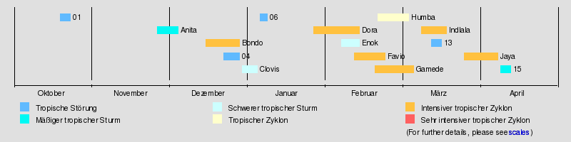
Storms
Tropical disturbance 01
| Tropical disturbance ( MFR ) | |||
|---|---|---|---|
|
|||
| Duration | October 19 - October 23 | ||
| intensity | 20 kn (35 km / h ) (10 minutes) | ||

On October 19, a zone of disturbed weather that had existed for two days near the equator was declared the first tropical disturbance of the season by the RSMC on La Réunion . No periodic warnings were issued for the next three days because the disorder was not expected to develop. On October 22nd, however, the system intensified and in anticipation of the system's deepening, the RSMC began issuing full storm warnings. However, no further development followed, and on October 23, the RSMC issued the final warning
Moderate Tropical Storm Anita
| Moderate tropical storm ( MFR ) | |||
|---|---|---|---|
| Tropical storm | |||
|
|||
| Duration | November 26th - December 4th | ||
| intensity | 35 kn (65 km / h ) (10 minutes) , 996 hPa | ||


On November 25th, convection formed at 5 ° S and 55 ° E. The system was classified as a Disturbed Weather Zone by RSMC La Réunion on November 26 and declared a Tropical Disturbance on November 27 at 12:00 UTC . The Joint Typhoon Warning Center classified the system as a cyclone on November 23. The RSMC upgraded the fault to a moderate tropical storm on December 1, and the subregional Tropical Cyclone Advisory Center in Madagascar named Anita , which was also proposed by Madagascar. Increasing wind shear hampered development, and Anita did not manage to further intensify moving south. The RSMC La Réunion downgraded Anita to tropical disorder early on December 2, and the JTWC suspended its warnings at that time. Anita continued to weaken and the RSMC La Réunion issued its final warning on Anita early on December 3rd.
Intense Tropical Cyclone Bondo
| Intense Tropical Cyclone ( MFR ) | |||
|---|---|---|---|
| Category 4 cyclone | |||
|
|||
| Duration | December 15 - December 28 | ||
| intensity | 110 kn (205 km / h ) (10 minutes) , 930 hPa | ||


An area of convection was discovered on December 15, west-southwest of Diego Garcia. It moved west and got organized, so the JTWC triggered a Tropical Cyclone Forming Alert (TCFA). The system was classified as a tropical fault by Météo-France on December 17th . The JTWC classified the system as a tropical cyclone a day later, and during the day Météo-France upgraded the disruption to a moderate tropical storm. The storm was named Bondo by the Subregional Tropical Cyclone Advisory Center in Mauritius ; Malawi suggested this name . After a rapid phase of intensification, Météo-France reported on December 19 that Bondo had intensified into a severe tropical storm. After rapidly intensifying , the RSMC upgraded the storm to a tropical cyclone , ignoring the rules of the Dvorak technique . The JTWC found at the time that the cyclone intensified "at a faster rate than climatologically" usual, which was due to the radial outflow. Honolulu meteorologists upgraded the storm from a strong tropical storm at 3:00 a.m. UTC to a Category 3 cyclone at 3:00 p.m. UTC that day. The RSMC later classified Bondo as an intense tropical cyclone, which reached its greatest intensity with continuous ten-minute wind speeds of 110 knots (around 205 km / h) and a central air pressure of 930 hPa.
A cyclical new formation of the eyewall initiated the weakening of the cyclone. This moved further in a south-southwest direction, crossed an area with low vertical wind shear and began to re-intensify on December 23 near the northern tip of Madagascar. The storm moved parallel to the coast of the island to the south-southwest and, according to Météo-France, reached a secondary climax with a sustained wind speed of 75 knots (around 140 km / h) before the storm weakened again before crossing the coast. After Bondo's landfall at 12:15 p.m. UTC, the JTWC declared the system to be dissolved in its next warning at 6:00 p.m. UTC, while Météo-France classified the storm as a depression in the interior. On December 26th, Météo-France found that the original low pressure area had dissolved and a new low pressure area connected to Bondo had formed over the sea. During the course of the day, the RSMC La Réunion then stopped the warnings about Bondo.
In response to the exposure to the Bondo 35 43 inhabitants of the were Seychelles belonging Farquhar atoll evacuated; the eight remaining residents stayed in a concrete bunker on site. On the island of Agalega , Bondo fell at least 275 mm of precipitation. In Madagascar, the effects of the storm killed 11 people and one more was never found. Around 20,000 residents of the island state were made homeless by Bondo .
Tropical disturbance 04
| Tropical disturbance ( MFR ) | |||
|---|---|---|---|
|
|||
| Duration | December 22nd - December 28th | ||
| intensity | 20 kn (35 km / h ) (10 minutes) | ||
A vigorous convection zone developed northwest of Diego Garcia on December 22nd . This was described by the meteorologists in Mauritius in their high seas weather report on December 25th at 0:00 UTC as a tropical disturbance, and during the day the Météo-France Le Réunion classified the system as zone perturbée 04 . The next day, 04R, heading towards Madagascar, had organized itself sufficiently to be officially classified as a tropical disorder. On December 28, the RSMC downgraded the system to a zone of disturbed weather and stopped issuing warnings on 04R.
Heavy Tropical Storm Clovis
| Severe Tropical Storm ( MFR ) | |||
|---|---|---|---|
| Category 1 cyclone | |||
|
|||
| Duration | December 29th - January 4th | ||
| intensity | 62 kn (115 km / h ) (10 minutes) , 978 hPa | ||


On December 29, Météo-France began issuing irregular bulletins on a new zone of disturbed weather, east-southeast of the location where 04R was last observed. The Joint Typhoon Warning Center had already issued a TCFA on December 27, but Météo-France said on December 29 that the 04R's low-level circulation center had disbanded. During the night of December 29th, several short-lived eddies formed and eventually a new circulation arose around the center of the system, which justified a new number. The system became more organized on December 30th and was classified as a tropical disorder. At 12:00 PM UTC on December 31st, 05R was upgraded to Temperate Tropical Storm Clovis. The name Clovis was suggested by Mauritius . Three hours later, the RSMC Le Réunion reported that Clovis had sustained wind speeds of 50 knots (95 km / h) and a minimum air pressure of 987 hPa and upgraded the storm to a severe tropical storm. Clovis passed the Île Tromelin around 17:00 UTC on December 31, at a distance of about 20 km , with a wind speed of 100 km / h and gusts of 130 km / h. On January 3rd, the system came over land and a day later it disintegrated. Four people were killed in the effects of the storm and two more were missing. The storm left 13,465 residents of Madagascar homeless.
Tropical disturbance 06
| Tropical disturbance ( MFR ) | |||
|---|---|---|---|
|
|||
| Duration | January 5th - January 8th | ||
| intensity | 20 kn (35 km / h ) (10 minutes) | ||
On January 5th, a cloud cluster formed on the west coast of Madagascar. According to Météo-France, this developed into the sixth tropical disturbance of the season on January 8th, but during the course of the day the RSMC stopped the warnings because no further development was expected.
Intense Tropical Cyclone Dora
| Intense Tropical Cyclone ( MFR ) | |||
|---|---|---|---|
| Category 4 cyclone | |||
|
|||
| Duration | January 26th - February 13th | ||
| intensity | 105 kn (195 km / h ) (10 minutes) , 925 hPa | ||


On January 28, an area of disturbed weather west of Diego Garcia] was classified as a tropical disturbance by Météo-France. The Joint Typhoon Warning Center began issuing its own warnings about tropical cyclone 10S during the course of the day after it had recently announced a TCFA. The system was upgraded to a tropical depression on January 29 and a moderate tropical storm during the day. The storm was given the name Dora proposed by Mozambique . Dora meandered south for the next two days, gaining strength. Météo-France upgraded Dora to a tropical cyclone early on February 1st. Contrary to the predicted weakening, Dora intensified further before the storm reached its climax on February 3, annularly and after further intensification with wind speeds of 100 knots (around 185 km / h) and a central air pressure of 930 hPa. The storm then turned south-west, losing strength and completely losing its tropical properties on February 9th. Météo-France last mentioned the extra-tropical system on February 12th.
Cyclone warnings were issued to Rodrigues because of Dora , but the storm did not cause any damage to property or personal injury.
Severe tropical storm Enok
| Severe Tropical Storm ( MFR ) | |||
|---|---|---|---|
| Tropical storm | |||
|
|||
| Duration | February 6th - February 13th | ||
| intensity | 60 kn (110 km / h ) (10 minutes) , 978 hPa | ||


On February 7, the Joint Typhoon Warning Center published a Tropical Cyclone Formation Alert on a convection area east of the coast of Madagascar. Météo-France declared the system the eighth tropical disturbance of the season late the following day. On February 9, the JTWC classified the system as a tropical cyclone and marked it as 13S , just before the RSMC classified 08 as a tropical depression. The system was named Enok by the sub-regional Tropical Cyclone Advisory Center Madagascar , although Météo-France had not yet upgraded to a moderate tropical storm at the time. The name Enok was suggested by Namibia . With the next storm warning, the RSMC classified Enok as a severe tropical storm, but its weakening began the next day. On February 10, the RSMC downgraded Enok to a moderate tropical storm, and a day later the JTWC issued its final warning on Enok before the RSMC downgraded Enok further. The system was last mentioned by Météo-France when it was classified as a tropical fault.
Intense tropical cyclone Favio
| Intense Tropical Cyclone ( MFR ) | |||
|---|---|---|---|
| Category 4 cyclone | |||
|
|||
| Duration | February 11th - February 23rd | ||
| intensity | 105 kn (195 km / h ) (10 minutes) , 925 hPa | ||


Early on February 12, Météo-France pointed to a zone of disturbed weather and classified it as 09 and upgraded it to tropical disturbance twelve hours later. Late on February 13, the JTWC warned that a tropical cyclone was about to form, and the next day, Honolulu meteorologists classified the system as a tropical cyclone named 14S . On February 15, Météo-France upgraded the system to a moderately tropical storm. It received the name Favio proposed by the Seychelles . An advance warning of a cyclone with the warning level "yellow" was issued on the day because of the proximity of the system to La Réunion . This measure was lifted on February 16, as Favio was then a good distance south of the island. The storm intensified into a severe tropical storm early on February 18 and further intensified into a tropical cyclone on February 19. The small tropical cyclone reached the status of an intense cyclone the next day and peaked with a continuous ten-minute wind speed of 105 knots (195 km / h) and an air pressure of 925 hPa. The storm moved in a west-northwest direction and endangered Mozambique, where the authorities issued the highest warning level. The British Foreign Office issued travel warnings for British nationals pertaining to the Bazaruto Archipelago . The cyclone hit the African mainland as an intense tropical cyclone in the province of Inhambane on February 22 , exactly seven years after the day on which Eline was last hit by an intense tropical cyclone in Mozambique in 2000 . Inland, Favio quickly lost its strength and lost its cyclone status ten hours after landfall.
Favio damaged buildings including the Vilanculos Court and City Prison in Mozambique. Uprooted trees blocked the roads, hampering rescue operations. The cyclone killed four residents of the city and injured at least seventy more. Thousands of houses were destroyed, including the city's hospital and power grid. 120 patients from the hospital were evacuated and 600 prisoners escaped. Telecommunications connections were broken on the island of Bazaruto . The storm also left uprooted trees and covered roofs in Pontagea, a densely populated suburb of the port city of Beira . A total of ten people were killed in the storm and nearly 100 others were injured; the reported property damage was given as 71 million US dollars .
Intense tropical cyclone gamede
| Intense Tropical Cyclone ( MFR ) | |||
|---|---|---|---|
| Category 3 cyclone | |||
|
|||
| Duration | February 19 - March 6 | ||
| intensity | 90 kn (165 km / h ) (10 minutes) , 935 hPa | ||


Météo-France began issuing warnings of a tropical disruption south-southeast of Diego Garcia on February 20 . During the day, the system was quickly upgraded to a Tropical Depression, and the next day, after the system became stormy, it was named Gamede . After the storm moved west and intensified into a severe tropical storm, Mauritius Meteorological Services issued a class 1 cyclone warning. As Gamede intensified into a tropical cyclone early on February 23, the warning level was raised. The system, which at the time was creating a wind field of 30-knot winds 500 km in diameter, intensified as it moved west-southwest. The authorities on Réunion therefore issued a “yellow” cyclone alarm. In Mauritius, the warning level was increased to class 3, as the radius of the strong winds approached the island. On February 4th, the cyclone expanded and the warning level for Réunion was increased from “yellow” to “orange”. During the course of the day, the “red” warning level became effective for the island for the first time in the season. Mauritius upgraded its cyclone warning to class 4 early on February 25 because wind gusts reached more than 120 km / h in the vicinity of the island. However, the warnings were discontinued here during the day because the cyclone was moving away from the island.
After a slight weakening from dry air, Gamede intensified into an intense tropical cyclone thanks to the reorganization of convection near its center. Early on February 26, Météo-France lifted the red alert for Réunion because the cyclone had withdrawn and no further threat to the island, but a few hours later Madagascar authorities declared thirteen areas to be dangerous. On February 27th, Météo-France put the "orange" alert for Réunion back into force, because the system was undergoing cyclical regeneration of eyewalls and was growing in size. Due to the approach of the cyclone, the warning level was raised again to "red" on the evening of February 27th. A bridge was washed away by floods, causing property damage of 20 million euros . The "red" alarm was lifted early on February 28th. Gamede moved south between Réunion and Madagascar and began to weaken. On March 1st, Gamede was downgraded to a severe tropical storm. Then the transition to an extratropical storm began and the center broke away from convection. Therefore, on March 2, the JTWC and Météo-France issued their last warnings about Gameda.
Gamede broke numerous records and set new highs for accumulated precipitation over 72 hours and over nine days. Between February 24th and 27th, Réunion received 3929 mm of rain.
Tropical cyclone Humba
| Tropical cyclone ( MFR ) | |||
|---|---|---|---|
| Category 1 cyclone | |||
|
|||
| Duration | February 20th - March 4th | ||
| intensity | 75 kn (140 km / h ) (10 minutes) , 960 hPa | ||


A low pressure area southwest of Sumatra was first mentioned in the three-day forecasts of the Bureau of Meteorology on February 19 . It slowly developed tropical and crossed the 90th east longitude on February 20 and was classified as Tropical Fault 11 by Météo-France. The next day, the JTWC issued a Tropical Cyclone Formation Alert and, a few hours later, when convection flared up, classified the system as a tropical cyclone and assigned the designation 16S . The RSMC upgraded 11R to Tropical Depression on February 22nd. In the next two days the system strengthened only a little, but the convection was extensive. On February 23, the system was upgraded and named a tropical cyclone. The Nme Humba was proposed by Tanzania . The storm continued to intensify and during the day Humba was upgraded to a severe tropical. On February 23, Humba intensified into a tropical cyclone. With a wind speed of 80 kn (around 150 km / h) and a central air pressure of 960 hPa, the cyclone reached its peak, then began to weaken and on February 26, Humba was downgraded to a severe tropical storm. During the day, Humba became a nontropical system and the JTWC issued the final warning about the storm. Météo-France continued the warnings until the following day.
Intense tropical cyclone Indlala
| Intense Tropical Cyclone ( MFR ) | |||
|---|---|---|---|
| Category 4 cyclone | |||
|
|||
| Duration | March 9th - March 19th | ||
| intensity | 95 kn (175 km / h ) (10 minutes) , 935 hPa | ||


On March 10, Météo-France pointed to a convection area at 60 degrees east longitude and marked it as 12 . The next day, the RSMC classified the system as a tropical disturbance. The tropical disturbance intensified during the day to a tropical depression and under favorable conditions early on March 12th to a moderate tropical storm. The name Indlala was suggested by Swaziland . Indlala intensified further and upgraded to a severe tropical storm. On March 13, the storm reached the intensity of a tropical cyclone. The conditions for further development were favorable and infrared images showed a temporary eye . The cyclone continued to intensify, the eye defined better, and the next day Indlala reached the strength of an intense tropical cyclone. This moved west towards Madagascar. After landfall near Antalaha on March 15 , when the cyclone was just undergoing new eyewall formation, Indlala weakened rapidly. On March 17, the storm broke up overland and Météo-France issued the final warning on Indlala.
The impact of Indlala killed at least 150 people and another 126 have been missing since the storm passed. According to official information, 188,331 residents of Madagascar were made homeless by the storm. The property damage caused by the cyclone was put at 240 million US dollars.
Tropical disturbance 13
| Tropical disturbance ( MFR ) | |||
|---|---|---|---|
|
|||
| Duration | March 13th - March 17th | ||
| intensity | 20 kn (35 km / h ) (10 minutes) | ||
On March 13, Météo-France began issuing bulletins on a zone of disturbed weather that had been bobbing through the south-central Indian for three days, as satellite images showed improved circulation at ground level. The disorder developed enough organization on March 15 to be classified as a tropical depression, but did not intensify further. The last warning about the disintegrating system was issued on March 17th.
Intense tropical cyclone Jaya
| Intense Tropical Cyclone ( MFR ) | |||
|---|---|---|---|
| Category 3 cyclone | |||
|
|||
| Duration | March 26th - April 8th | ||
| intensity | 100 kn (185 km / h ) (10 minutes) , 935 hPa | ||


An area of sheared convection was discovered on March 25 in the central southern Indian Ocean. Four days later, Météo-France began issuing bulletins on the disturbed weather zone, which had a partially exempted circulation center. At first the bulletins were issued irregularly, but the system quickly organized and was upgraded to a tropical depression on March 30th. The sub-regional warning center in Mauritius called the system a moderate tropical storm and named it Jaya ; the name was suggested by Zimbabwe . The Joint Typhoon Warning Center referred to the system as 22S during the day , but it wasn't until a few hours later that the RSMC classified Jaya as a moderate tropical storm. This intensified further, and early on March 31st, Jaya achieved tropical cyclone status. The rapid intensification continued, and on the afternoon of March 31, Jaya reached its climax as an intense tropical cyclone with wind speeds of 100 kn (185 km / h) and a minimum air pressure of 930 hPa.
Due to the small size of the system, the structure and size were easily fluctuated. On April 1, Jaya had weakened slightly, and infrared images showed disorganization caused by increased wind shear. Jaya was therefore downgraded to a tropical cyclone. When Jaya approached northeast Madagascar late on April 2nd, the cyclone was upgraded to an intense tropical cyclone again after the convection improved. However, dry air and wind shear caused Jaya to lose strength and appear disorganized shortly before crossing the coast.
After the landfall of Jaya on April 3rd around 08:00 UTC near Sambava as a tropical cyclone with gusts of wind between 180 and 200 km / h. The storm surfaced again in the Strait of Mozambique as a disorganized system with no convection and the RSMC Réunion issued its final warning on Jaya.
On April 5, convection consolidated around the center of the residual circulation of the cyclone and the system reorganized into a tropical fault, so Météo-France issued a warning about the fault at 12:00 UTC, but indicated that wind shear was a significant Reintensification hinders. The proximity to the Mozambique coast, which the fault moved along without crossing, also affected the system. In the next two days Jaya came under the influence of strong wind shear and became significantly weaker. On April 7, the system underwent a brief rapid intensification, so that Météo-France issued a bulletin again, but the convection soon faded almost completely, so that Météo-France finally stopped the warnings because of the exemption from Jaya's circulation.
According to reports from Reuters three people were killed by the impact of the cyclone and many houses destroyed. Several plantations were also devastated.
Subtropical storm 15
| Subtropical Storm ( MFR ) | |||
|---|---|---|---|
|
|||
| Duration | April 9th - April 13th | ||
| intensity | 50 kn (95 km / h ) (10 minutes) , 994 hPa | ||


On April 11th, Météo-France began issuing warnings about a subtropical system south of Madagascar. The system was located above water with a surface temperature of 25 ° C and was associated with weak convection. Due to a decrease in wind shear, the system had organized itself sufficiently to be assessed as a subtropical depression. However, the system was on the verge of being transformed into an extra-tropical low-pressure area, which happened a day later after the wind shear increased again. In the post-analysis of the system, it was found that it had formed as early as April 9th and deepened into tropical disturbance late on April 10th, before developing subtropical properties and eventually reaching storm strength.
Season overview
Storm names
In the Southwestern Indic, a tropical disturbance is named when it reaches the strength of a moderate tropical storm. If this occurs west of the 55th east longitude, then the corresponding name is assigned by the sub-regional Tropical Cyclone Advisory Center in Madagascar ; east of the 55th degree of longitude the name is given by the sub-regional Tropical Cyclone Advisory Center in Mauritius . A new list of names is used every year so that in the case of destructive cyclones no names are removed from the list of tropical cyclone names . The following names were intended for the 2006-2007 season.
|
|
See also
- Atlantic hurricane seasons: 2006 , 2007
- Pacific hurricane seasons: 2006 , 2007
- Pacific Typhoon Seasons: 2006 , 2007
- North Indian cyclone seasons: 2006 , 2007
- South Pacific cyclone season 2006-2007
- Australian cyclone season 2006-2007
supporting documents
- ↑ a b c d The 2006–2007 Summer Season Outlook ( English ) Mauritius Meteorological Services. Archived from the original on April 5, 2007. Retrieved May 16, 2013.
- ↑ a b c d e f g h i Tropical Cyclone Operational Plan for the South-West Indian Ocean - 2006 Edition. (PDF; 461 kB) wmo.ch, archived from the original on November 2, 2006 ; accessed on May 16, 2013 .
- ↑ Seychelles atoll battens down for cyclone Bondo ( English ) Reuters AlertNet. December 21, 2006. Archived from the original on March 5, 2008. Retrieved May 16, 2013.
- ↑ Tropical Cyclone Bondo approaches North Madagascar ( Memento from May 29, 2007 in the Internet Archive )
- ↑ a b c Tropical Cyclone Committee: Madagascar: Review of the 2005/2006, 2006/2007 and 2007/2008 Cyclone seasons ( English , DOC; 1.2 MB) World Meteorological Organization. September 5, 2008. Retrieved April 30, 2012.
- ^ Fear as cyclone nears Mozambique (English) . In: BBC News , February 21, 2007. Retrieved April 30, 2012.
- ^ Warning to Mozambique travelers (English) . In: BBC News , February 22, 2007. Retrieved April 30, 2012.
- ^ Communique ( Memento of March 22, 2007 on WebCite )
- ^ Cyclone Favio strikes Mozambique (English) . In: BBC News , February 23, 2007. Retrieved April 30, 2012.
- ↑ Charles Mangwiro: Mozambique cyclone kills 4, injures at least 70 ( English ) Reuters AlertNet. February 23, 2007. Archived from the original on March 21, 2007. Retrieved on May 16, 2013.
- ↑ SAPA: Cyclone may hit tourist resorts ( English ) News24. March 11, 2007. Archived from the original on October 7, 2008. Retrieved April 30, 2012.
- ↑ tableau-des-alertes ( Memento from September 22, 2012 on WebCite )
- ^ Cyclone nears coastline of Reunion Island; 1 woman reported missing - International Herald Tribune
- ↑ Bulletin Special D'information ( French ) meteo.fr. February 20, 2010. Archived from the original on March 22, 2007. Retrieved on May 16, 2013.
- ↑ Faq: Hurricanes, Typhoons, And Tropical Cyclones
- ↑ Tropical Cyclone Forecast Warning (South-West Indian Ocean) ( English ohio-state.edu). Archived from the original on April 3, 2007. Retrieved May 16, 2013.
- ↑ Tropical Cyclone Forecast Warning (South-West Indian Ocean) ( English ohio-state.edu). Archived from the original on April 3, 2007. Retrieved May 16, 2013.
- ↑ World weather impacts Cyclone Jaya kills 3 - April 10, 2007 ( Memento from August 16, 2007 in the web archive archive.today )
- ↑ WebCite query result ( Memento from April 13, 2007 on WebCite )
- ^ Tropical Cyclone Operational Plan for the South Pacific and South-East Indian Ocean (PDF) World Meteorological Organization. 2003. Retrieved on August 15, 2008. ( Page no longer available , search in web archives )
- ↑ La Réunion - Météo-France: List des noms des tempêtes et cyclones tropicaux pour la Saison 2006-2007 sur le Sud-Ouest de l'Océan India ( French ) 2007. Archived from the original on March 2, 2008. Retrieved on March 31, 2008. January 2008.
Web links
- Joint Typhoon Warning Center . (JTWC)
- Météo-France . (RSMC La Réunion)
- World Meteorological Organization (WMO)