Komati
|
Komati Komati River, Nkomati River, Nkomazi River, Rio Incomáti |
||
|
The catchment area of the Komati |
||
| Data | ||
| location |
( Mpumalanga Province ) Swaziland Mozambique ( Maputo Province ) |
|
| River system | Komati | |
| source | northeast of Ermelo (South Africa) 26 ° 16 ′ 1 ″ S , 30 ° 7 ′ 45 ″ E |
|
| Source height | 1832 m | |
| muzzle | north of Maputo in the Maputo Bay Coordinates: 25 ° 52 '23 " S , 32 ° 43' 37" E 25 ° 52 '23 " S , 32 ° 43' 37" E |
|
| Mouth height | 0 m | |
| Height difference | 1832 m | |
| Bottom slope | 4.1 ‰ | |
| length | 450 km | |
| Catchment area | 46,246 km² | |
| Discharge at gauge E43 - Magude A Eo : 37,500 km² Location: 150 km above the mouth |
MNQ 1970–2011 MQ 1970–2011 Mq 1970–2011 MHQ 1970–2011 |
7.1 m³ / s 47.4 m³ / s 1.3 l / (s km²) 51.8 m³ / s |
| Left tributaries | Mlumati (Lomati), Crocodile River , Sabie , Massintonto, Uaneteze, Mazimechopes | |
| Reservoirs flowed through | Nooitgedacht Dam , Vygeboom Dam , Maguga Dam | |
| Medium-sized cities | Komatipoort , Marracuene | |
| Small towns | Sábiè , Magude | |
| Residents in the catchment area | 2,294,542 (2003) | |
|
The Komati just before the mouth |
||
The Komati (English Komati River , also Nkomati River or Nkomazi River , port. Rio Incomáti ) is a river in Africa. It passes through South Africa , Swaziland and Mozambique , where it flows into the Indian Ocean .
Origin and course

The Komati rises in the northern Drakensberg at an altitude of 1832 meters above sea level in the area of Ermelo in the Mpumalanga province . It flows south of Barberton and is diverted north on the northeast border of Swaziland. From there it flows in a northeast direction and keeps a parallel course to the Lebombo Mountains . Before reaching the mountains, the Komati joins the Crocodile River at Komatipoort and then flows through a 190 meter deep gorge, the Komatipoort ("Komatipforte"), after which the city of Komatipoort is named.
On the border between South Africa and Mozambique , the river is less than 100 kilometers from the sea. However, the river does not take the direct route, but crosses the coastal plain in a wide arc of around 320 kilometers, first to the north and then to the south. From the north, other tributaries flow into the Komati. In the estuary, the river forms extensive lagoons and flows around islands. The Komati reaches the Indian Ocean 24 kilometers north of Maputo , at Marracuene across the Maputo Bay . It has a length of approximately 450 km. Sometimes 714 km are also given.
During the flood season there is a water-bearing connection through the swamps with the Limpopo basin in the north.
Hydrometry
The flow rate of the Komati was measured in m³ / s at the Magude station , about 150 km from the mouth (1970 to 2011).

Catchment area
The catchment area of the Komati is given as an area of 46,246 to 46,800 km² and extends over three countries. It is divided as follows:
| country | Area [km²] | percent |
|---|---|---|
| South Africa | 28,600 | 61.2 |
| Swaziland | 2,500 | 5.4 |
| Mozambique | 15,600 | 33.4 |
| Komati as a whole | 46,700 | 100.0 |
railroad
The Pretoria – Maputo railway crosses the plain and reaches the Komati at km 72 of the CFM . It then follows the southern bank of the river and reaches the highlands at Komatipoort.
economy
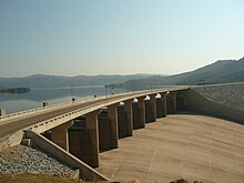
The Maguga Dam dams the river 12 kilometers south of the town of Piggs Peak in Swaziland. The dam is 115 meters high and was completed in September 2001. Because of its periodic flooding, several regulation work was carried out in its course.
In the lowlands of its lower reaches in Mozambican territory lie sugar cane plantations near Xinavane and Manhiça .
Web links
Individual evidence
- ↑ a b c Description of the Komati and other waters in Swaziland (English), accessed on September 29, 2014
- ^ A b c Environmental Profile of the Inkomati River Basin
- ↑ a b Drivers of spatial and temporal variability of streamflow in the Incomati River basin
- ^ Sharing the Incomati waters: Cooperation and Competition in the Balance
- ↑ Information at ecs.co.sz ( Memento from February 8, 2012 in the Internet Archive ) (English; archive version)
- ↑ Manfred Kuder: Moçambique. a geographical, social and economic study of the country . Scientific regional customers Volume 10, Darmstadt 1975, p. 276


