
Sachsenrast

Coordinates: 52 ° 2 ′ 11.2 " N , 7 ° 50 ′ 24.4" E
The Sachsenrast , sometimes also called Saxenrast , was a relay and post station on the N3 from the French times in Ostbevern and is now a modern residential and commercial building. Before the Département de l'Ems-Supérieur was established, the canton of Ostbevern was established in 1810 . As mayor of Canton was Friedrich Clement of Bever Fjord been appointed to the " pre-emptive obedience " the construction of the sub-section of the N3, also called "routes imperial" or Napoleon road called, carried out within his canton and had also reached the Saxons break in this context. The building was demolished in 1976 and rebuilt as a commercial and residential building from 1977-78.
description
The Sachsenrast consisted of two buildings. On the front side in the main building there was an inn, a post office and a place to stay. In the east side wing was the horse stable (Evens Piädstall), in which the horses were sheltered to be changed. The name Sachsenrast has always been the name of the bar and is likely to have its origin in the fact that the route from Westphalian to Lower Saxony led here, i.e. a break on the way to Saxony.
history

.JPG)
From 1735 post offices and post stations were expanded and the postal service now also carried people by coach. In the middle of the 18th century the stagecoaches had established themselves as the most important means of transport in overland traffic. From 1800 onwards, a higher organization was established with the establishment of a general postal directorate. A dense network of relay stations and post roads now ran through the country.
On January 1, 1811, the Napoleonic Post was introduced in the Obere Ems department , which also made new mail routes necessary. The French word Chaussee describes a road with pounded stones, synonymous with the German terms “Straßendamm” or “Hochweg” and the English “highway”. New for the Napoleon-Chausseen was the complex construction of the pavement, which consisted of a multi-part substructure. To do this, the ground was first removed and larger stones, gravel or crushed stone applied in layers. The carriageway, curved towards the middle, was also flanked by ditches and avenue trees. The road was designed according to military considerations, it had a total width of approx. 15 m and in addition to the paved 4.5 to 8 m wide roadway for artillery teams, an adjacent 3.5 m wide gravel path for infantry columns, as well as an unpaved 3.5 m wide summer path . The entire road layout was pretty straight forward, with a continuous route measurement through milestones.
For the route of the N3 ( Paris - Liège - Wesel - Hamburg ), which is now part of the federal highway 51 , the postal route from Münster to Osnabrück, which ran via Ladbergen and Lengerich (roughly the course of today's federal highway 1 ) since 1688 , was used, for military reasons (inclines or declines of three to five percent were not allowed to be exceeded for the heavy artillery limbs ) via Telgte , Ostbevern , Glandorf , Iburg to cross the Teutoburg Forest between the Dörenberg and the Hohnsberg . The main street of Ostbevern was part of it and only later did the B 51 bypass the place. In the canton of Ostbevern, however, work began much earlier than the planning in Paris was not yet completed. This was due to the diligence of the newly appointed Maire Friedrich Clemens von Beverförde , who began work in his canton (from Telgte to Glandorf) as early as May 1811, even before the order to do so had arrived from Paris. This is also evidenced in numerous correspondence with his Prefect Charles-Louis de Keverberg de Kessel :
" Loburg d [en] May 13, 1811
The Maire zu Ostbevern to the Prefect of the Ober-Ems, Knight of the Legion of Honor,
Mr. Prefect!
In response to the complaints and ideas sent to me by Messrs. Maires von Laer and Lienen regarding the workers to be deployed for road construction, I have the honor to report obediently that it is, however, hard that these people are now being held up in their summer sowing. "
The planning in Paris was completed on January 25, 1812, and regulations were issued on April 4, 1812, regulating the organization, legal issues and costs. The decisive factor for the construction was that the work had to be carried out by the cantons along the Chaussee. In Ostbevern (2221 inhabitants as of 1811) and the surrounding area, up to 300 workers and farmers and 15 two-horse wagons were forcibly recruited. In comparison, Ladbergen with 2179 inhabitants (as of 1811) only had 150 workers and 15 two-horse wagons to provide. When the order to build was issued from Paris on December 11, 1812, the work in the canton of Ostbevern - from Telgte to Glandorf, approx. 20 km - was already largely complete.
Although the connection between Münster , the capital of the Département Lippe , and Osnabrück , the capital of the Département de l'Ems-Supérieur , could be completed, despite all the pressure, the N3 was not completed in the entire course from Paris to Hamburg and thus its real purpose missed. Nevertheless, the new Chaussee led to the economic boom in Ostbevern in the 19th century, which was able to retain the character of a street village from now on into the 20th century . The Sachsenrast was built as a relay station in the center of the village, right next to the St. Ambrosius Church . It remained as an inn and exchange station for stagecoach horses until the end of the 19th century. The tenant was the innkeeper and postman Ewen, who was also a miller in the village. When the Wanne-Eickel-Hamburg railway with the Münster-Osnabrück section was opened on September 1, 1871 , the age of the stagecoach ended . The post office moved into the larger building opposite, "Esselmanns Haus", today's Finke inn ("Zur alten Post"). The Sachsenrast was a simple bar with an attached horse stable, which was initially used as accommodation for the state stud stallions of the North Rhine-Westphalian state stud in Warendorf . The last tenant was the innkeeper Weglage. In 1976 the historic building was demolished despite its monumental value. In the same place, the local architect Hermann Schapmann, who was or is also a local council member and deputy chairman of the Heimatverein , built a residential and commercial building that only has the floor plan in common with the old Sachsenrast.
photos
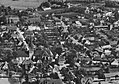
Based on the sequence of images, you can see the development away from the street village quite well . Only the steeple of the St. Ambrosius Church remains in the same place.

Ostbevern with the Sachsenrast 1922 shows the character of a street village
Ostbevern already with a new church in 1962, the narrow passage between Sachsenrast and the old church can be clearly seen

Ostbevern with the "new" Sachsenrast and the small old church in 1979, the main street still prominent
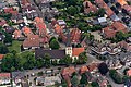
Ostbevern with the new Sachsenrast 2014, the main street paved and pulled back by wide sidewalks


literature
- Architectural and art monuments of Westphalia . On behalf of the Provincial Association, edited by Wilhelm Rave Provincial Conservator 42nd Volume: Warendorf District, edited by Karl Hölker, Aschendorfsche Verlagsbuchhandlung, Münster 1936.
- Vicar Gr. Vorspohl in connection with the parish of St. Ambrosius Ostbevern (ed.): Wayside crosses and wayside shrines in the parish of St. Ambrosius Ostbevern. Krimphoff, Füchtorf 1978, ISBN 3-921787-03-9 , number 85 (authors: Josef Gr. Vorspohl, Reinhard Drees, Norbert Reher).
- Siegfried Schmieder: Ostbevern, contributions to the history and culture of a community in the Münsterland , Warendorf 1988.
Web links
Individual evidence
- ↑ Heimatverein Ostbevern
- ↑ right and left of the Chaussee between Glandorf and Bad Iburg, editor's note. Author
- ^ Franz Meyer: Geschichte der Gemeinde Ostbevern , Ostbevern 2000, ISBN 3 00 006943 7 , p. 129
- ^ Westfälische Nachrichten September 27, 2003
- ↑ Heimatverein Ostbevern