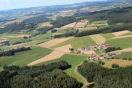
Sallach (Niedermurach)
|
Sallach
community Niedermurach
Coordinates: 49 ° 25 ′ 38 ″ N , 12 ° 23 ′ 29 ″ E
|
|
|---|---|
| Height : | 510 m |
| Postal code : | 92545 |
| Area code : | 09671 |
Sallach is a district of the community of Niedermurach in the Upper Palatinate district of Schwandorf ( Bavaria ).
Geographical location
Sallach is about three kilometers south of Niedermurach on the southwest slope of the 655 m high Kätzlesberg.
history
Sallach is mentioned for the first time in 1270 in the description of the property of the Bavarian duke .
In the report of the chaplain Heinrich Beier from 1580 Sallach is mentioned as belonging to the parish of Murach Castle.
Then Sallach is mentioned in writing in the boundary description of the Murach nursing office from 1581. It belonged to the municipality of Wagnern, which was subordinate to four different lower courts due to the fragmented rule. In Sallach two teams belonged to Christoph von Dorndorf and the rest to the Murach nursing office.
Despite this confused rule, the municipality of Wagnern with its 5 districts: Wagnern, Mantlarn, Sallach, Alt Weichelau and Schwaighof showed a strong sense of togetherness and knew how to defend itself against various arbitrary measures and injustices by its various authorities.
Sallach also appears in the draft protocols from 1587.
In 1946, when the government in Regensburg ordered the destruction of the municipality of Wagnern, whereby Sallach and Schwaighof came to Niedermurach, the population successfully defended itself, so that in 1948 the municipality of Wagnern was restored to its previous size.
On March 23, 1913 (Easter), Sallach was part of the Oberviechtach parish and had 5 houses and 34 residents. In 1924, Sallach was repared from Oberviechtach to Dieterskirchen .
On December 31, 1968 the municipality of Wagnern with its five districts Wagnern, Mantlarn, Sallach, Alt Weichelau and Schwaighof had 172 inhabitants and an area of 697 hectares. On December 31, 1990 Sallach had 33 inhabitants and belonged to the parish Dieterskirchen.
photos
literature
- Heribert Batzl (Ed.): The Oberviechtach district in the past and present. Publishing house for authorities and economy R. Alfred Hoeppner, Aßling / Obb. and Munich 1970.
Web links
Individual evidence
- ↑ Fritsch hiking map Schönseer Land, scale 1: 35000
- ^ A b c Erich Mathieu: From the history of the communities Lind, Niedermurach, Obermurach, Pertolzhofen and Wagnern. In: Heribert Batzl (ed.): The district of Oberviechtach in the past and present. Publishing house for authorities and economy R. Alfred Hoeppner, Aßling / Obb. and Munich 1970, pp. 89, 90.
- ↑ Erich Mathieu: On the history of the city of Oberviechtach. In: Heribert Batzl (ed.): The district of Oberviechtach in the past and present. Publishing house for authorities and economy R. Alfred Hoeppner, Aßling / Obb. and Munich 1970, p. 75.
- ↑ Erich Mathieu: On the history of the city of Oberviechtach. In: Heribert Batzl (ed.): The district of Oberviechtach in the past and present. Publishing house for authorities and economy R. Alfred Hoeppner, Aßling / Obb. and Munich 1970, p. 66.
- ^ Antonius von Henle (Ed.): Register of the Diocese of Regensburg. Verlag der Kanzlei des Bischöflichen Ordinariates Regensburg, 1916, p. 381
- ^ Hans Berger: The district of Oberviechtach in numbers. In: Heribert Batzl (ed.): The district of Oberviechtach in the past and present. Publishing house for authorities and economy R. Alfred Hoeppner, Aßling / Obb. and Munich 1970, pp. 163-168.
- ↑ Manfred Müller (Ed.): Register of the diocese of Regensburg. Verlag des Bischöflichen Ordinariats Regensburg, 1997, p. 117


