San Pascual (Batangas)
| Municipality of San Pascual | ||
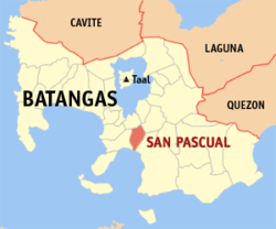
| Location of San Pascual in the Batangas Province | ||
|---|---|---|

|
||
| Basic data | ||
| Region : | CALABARZON | |
| Province : | Batangas | |
| Barangays : | 29 | |
| District: | 2. District of Batangas | |
| PSGC : | 041026000 | |
| Income class : | 1st income bracket | |
| Households : | 9744 May 1, 2000 census
|
|
| Population : | 65,424 August 1, 2015 census
|
|
| Population density : | 1712 inhabitants per km² | |
| Area : | 38.22 km² | |
| Coordinates : | 13 ° 48 ' N , 121 ° 3' E | |
| Postal code : | 4204 | |
| Mayor : | Mario V. Magsaysay Jr. | |
| Geographical location in the Philippines | ||
|
|
||
San Pascual is a Filipino municipality in the Batangas Province . It has 65,424 inhabitants (August 1, 2015 census).
geography
The borough is bordered by Batangas City to the east and Bauan to the west. The community has an area of 38.22 km² and the topography is considered to be a flat hilly landscape. Batangas Bay is in the south of the municipality .
history
San Pascual used to be part of the municipality of Bauan called Lagnas . In 1969, San Pascual became an independent municipality.
economy
The township is home to an oil refinery, chemical plants, and other industries and businesses.
politics
The borough government is headed by re-elected Mayor Mario V. Magsaysay Jr.
Barangays
San Pascual is politically divided into 29 barangays .
- Alalum
- Antipolo
- Balimbing
- Banaba
- Bayanan
- Danglayan
- Del Pilar
- Gelerang Kawayan
- Ilat North
- Ilat South
- Kaingin
- Laurel
- Malaking Pook
- Mataas na Lupa
- Natunuan North
- Natunuan South
- Padre Castillo
- Palsahingin
- Pila
- Poblacion
- Pook Ni Banal
- Pook Ni Kapitan
- Resplandor
- Sambat
- San Antonio
- San Mariano
- San Mateo
- Santa Elena
- Santo Niño
