Sandhausen (Osterholz-Scharmbeck)
|
Sandhausen
City of Osterholz-Scharmbeck
|
|
|---|---|
| Coordinates: 53 ° 15 ′ 54 ″ N , 8 ° 48 ′ 58 ″ E | |
| Height : | 15 m above sea level NHN |
| Incorporation : | March 1, 1974 |
| Postal code : | 27711 |
| Area code : | 04791 |
|
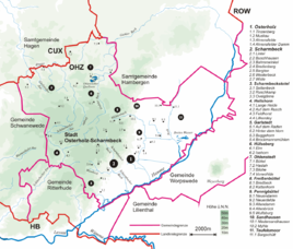
Location of Sandhausen in the city of Osterholz-Scharmbeck
|
|
|
Sandhausener mill
|
|
Sandhausen is a district of the county town Osterholz-Scharmbeck in the Lower Saxony district Osterholz .
geography
The place is northeast of the city center Osterholz-Scharmbeck on the B 74 . East, the 254 extends ha large nature reserve (NSG) Moor at low Sandhausen and southeast, the 185-hectare nature reserve Pennigbütteler Moor .
history
Sandhausen was founded as part of the moor colonization of the Teufelsmoor in 1780. In 1789, it is stated that the place had five houses in which 19 residents, including nine children, lived. In 1910 the place had 178 inhabitants.
societies
- TSV Sandhausen e. V. was founded in 1965.
Web links
Commons : Sandhausen - Collection of Images
Individual evidence
- ↑ a b Dietrich Heinrich Stöver: Historical-statistical contributions to the closer knowledge of the states and the newer world affairs . Benjamin Gottlob Hoffmann, Hamburg 1789, p. 347 ( digitized version [accessed November 25, 2017]).
- ^ Municipal directory Germany 1900. Kingdom of Prussia - Province of Hanover - District of Stade - District of Osterholz, District of Osterholz. In: www.gemeindeververzeichnis.de. 2014, accessed November 25, 2017 .
- ^ Website of TSV Sandhausen e. V. from 1965. Retrieved March 15, 2019.


