Sandling
| Sandling | ||
|---|---|---|
|
West side of the Vorderen Sandlingalm |
||
| height | 1717 m above sea level A. | |
| location | Styria , Austria | |
| Mountains | Dead Mountains | |
| Dominance | 4.2 km → Loser | |
| Notch height | 806 m ↓ forest ditch | |
| Coordinates | 47 ° 39 '23 " N , 13 ° 42' 51" E | |
|
|
||
| rock | Plassenkalk , Tressensteinkalk , Oberalmer layers | |
| Age of the rock | Upper Jurassic | |
| particularities | Altaussee salt mine | |
|
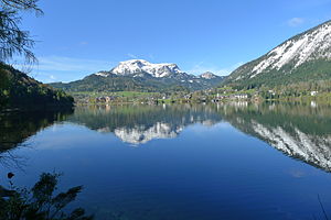
Altausseer See with sandling in late autumn |
||
The Sandling is 1717 m above sea level. A. high, isolated mountain on the southwestern edge of the Dead Mountains . The mountain range is located in the Ausseerland in the Styrian Salzkammergut region, right on the border with Upper Austria and contains the largest salt deposits in Austria.
Salt mining
In 1993, a Roman settlement (Michlhallberg) from the 2nd to 4th centuries AD was discovered on the southern slope of the mountain at 1000 m above sea level. It is suspected that there was already Roman salt mining there.
The first documentary mention of Aussee salt mining is dated to 1147. In the early days, the salt was produced directly at the foot of the mountain, from the 13th century it was fed into the Bad Aussee saltworks via brine pipes . In 1906 a brine pipeline was built from Altaussee to Bad Ischl to be forwarded to the saltworks in Ebensee am Traunsee . Since the closure of the salt works in Bad Aussee in 1983, the brine has been directed exclusively to Ebensee, where the salt smelting of the Altaussee, Hallstatt and Bad Ischl mining areas is now carried out. The mining in Altaussee is still in operation today and with a production of 550,000 tons of salt (2005) it is the largest salt production site in Austria.
Between 1943 and 1948, the Altaussee salt mine was located in the salt mine . Art treasures from Austria and substantial parts of the looted art stolen from all over Europe by National Socialist organizations for Adolf Hitler , Hermann Göring and Joseph Goebbels were stored there.
Today, parts of the mine are open to visitors as a show mine.
Surname
In Altaussee, the sandling is often simply called “Soizbärig” (= salt mountain) or “Bärig” (= mountain), which reflects its historically important economic importance for the place.
Landslide
On the night of September 12th to 13th, 1920, there was a massive landslide on the Sandling. The 1700 m high sandling tower on the west wall broke off. The over six million cubic meters of limestone in the rock pinnacle buried parts of the Vorderen Sandlingalm. The great deformability of the salt dome repeatedly leads to tensions and fractures in the overlying limestone layers.
Approaches & hiking trails
- From the Steinberg (942 m), the visitor access to the salt mine, the marked hiking trail No. 252 leads northwest to the Ausseer Sandlingalm, where it joins the hiking trail No. 201 Via Alpina in the direction of the Lambacher Hütte . At the saddle about 1340 m, which borders the Sandling in the north, the marked path no. 251 branches off to the left and leads south to the summit. Walking time around two and a half hours.
- From the Blaa Alm (894 m) the marked hiking trail no. 201 leads to the southwest over the Ausseer Sandlingalm towards the Lambacher Hütte. At the saddle about 1340 m, which borders the Sandling in the north, the marked path no. 251 branches off to the left and leads south to the summit. Walking time around two and a half hours.
- From the Vorderen Sandlingalm (1335 m), a path branches off from hiking trail no. 201 and leads, partly secured with ropes, steeply over the western flank of the mountain to the summit. Walking time around an hour.
- Starting from Altaussee, the mountain can be circumnavigated in around five hours.
At the foot of the mountain there is an extensive alpine pasture area with the Vorderen Sandlingalm and the Ausseer Sandlingalm.
Literature & Maps
- Wolfgang Heitzmann: Salzkammergut with the Totem Mountains and Dachstein: high-altitude trails, summit tours, via ferratas . Tour No. 44, pp. 174-177. New edition Bruckmann Verlag, Munich 2002, ISBN 3-7654-3336-5 .
- Alpine Club Map Bl. 15/1 (Totes Gebirge - West), 1: 25,000; Austrian Alpine Club 2014; ISBN 978-3-928777-29-2 .
- ÖK 50, sheet 96 (Bad Ischl), 1: 50,000.
Web links
- Search for Sandling in the SPK digital portal of the Prussian Cultural Heritage Foundation
- Salt mine Altaussee
- Rescuing the art collection from being blown up
Footnotes
- ↑ Gerald Grabherr u. a .: Michlhallberg. The excavations in the Roman settlement 1997–1999 and the investigation of the associated road route (= series of publications of the Kammerhof Museum Bad Aussee . Volume 22 ). Association of Friends of the Kammerhof Museum, Bad Aussee 2001, p. 11, 103 .
- ^ Aeiou, Austria Lexicon: Salt. Retrieved July 17, 2012 .
- ^ Announcements of the German and Austrian Alpine Club 1920, No. 17-20. 1920, accessed July 17, 2012 .
- ↑ International Symposium 'INTER PRAEVENT 1984 - VILLACH' (PDF; 1.2 MB)


