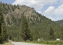
Sanpoil River
| Sanpoil River | ||
| Data | ||
| Water code | US : 1531504 | |
| location | Ferry County , Washington , USA | |
| River system | Columbia River | |
| Drain over | Columbia River → Pacific | |
| source | in the Okanagan Highland 48 ° 38 ′ 54 ″ N , 118 ° 38 ′ 12 ″ W. |
|
| Source height | 834 m | |
| muzzle | Columbia River Coordinates: 47 ° 56 ′ 55 " N , 118 ° 40 ′ 50" W 47 ° 56 ′ 55 " N , 118 ° 40 ′ 50" W. |
|
| Mouth height | 394 m | |
| Height difference | 440 m | |
| Bottom slope | 3.9 ‰ | |
| length | 113 km | |
| Catchment area | 2541 km² | |
| Right tributaries | West Fork Sanpoil River | |
| Small towns | Republic | |
The Sanpoil River (also spelled San Poil ) is a tributary of the Columbia River in Washington State . The name Sanpoil is derived from the Okanagan term [snpʕʷílx] , which means “people from the gray land”, or “gray as far as you can see”.
course

The Sanpoil River has its source near the city of Republic in the Okanagan Highland , east of the Okanogan River . It flows south through the Colville National Forest , the Okanogan National Forest, and the Colville Indian Reservation . After entering the reservation, the river takes its main tributary, the West Fork Sanpoil River. Then other small bodies of water flow in such as the Twentyone Mile Creek, the Twentythree Mile Creek and the Thirty Mile Creek.
The Sanpoil River flows into Franklin D. Roosevelt Lake (FDR Lake), the dammed Columbia River above the Grand Coulee Dam . The dam also dams the last miles of the Sanpoil River. This part of FDR Lake is called the Sanpoil Arm. How many tributaries of the Columbia River was the sanpoil tribe River an important trail for salmon before the river was dammed.
Relatively small numbers of adfluvial wild rainbow trout and escaped sockeye salmon migrate between the Sanpoil River and Lake Roosevelt. Black bass and glass-eyed perch , two non-indigenous predatory fish that roam the transition from river to lake during the juvenile migratory season, are suspected of eating large quantities of these species. To determine the percentage of fry eaten, Stroud et al. (2010, 2011) bioenergetic models linked to the estimated populations. They estimated that the predators accounted for 105 (95% confidence interval between 86 and 162) percent of semi-annual sockeye salmon, 39 (33–68) percent of year and a half sockeye salmon, 74 (60–118) percent of annual rainbow trout, and 53 (44–92 ) Percent of two- and three-year-old rainbow trout eat within 113 days.
Habitats
- Mountain rivers
- Mixed forests
- Wetlands
- Freshwater marshes
Birds
- Loons
- Spatula
- Golden eagle and bald eagle
- Rocky Mountains pygmy owl
- Black-chin hummingbird , star elf and red-backed cinnamon hand
- Blood-faced woodpecker and helmeted woodpecker
- Red-neck juice tasty
- Tannenschnäppertyrann , bushland Schnäppertyrann and banks tyrant
- Cassinvireo
- Dwarf nuthatch
- Bluethroat Warbler
- Riparian warbler
See also
Individual evidence
- ↑ a b Google Earth altitude calculation for GNIS coordinates.
- ↑ Grande Ronde River ( Memento of the original from March 9, 2005 in the Internet Archive ) Info: The archive link was inserted automatically and has not yet been checked. Please check the original and archive link according to the instructions and then remove this notice. , The Columbia Gazetteer of North America
- ↑ San Poil ( Memento of the original from July 13, 2007 in the Internet Archive ) Info: The archive link was automatically inserted and not yet checked. Please check the original and archive link according to the instructions and then remove this notice. , Intermountain Province Plan, Northwest Power and Conservation Council
- ^ A b Harry M. Majors: Exploring Washington . Van Winkle Publishing Co, 1975, ISBN 978-0-918664-00-6 , p. 55.
- ^ William Bright: Native American placenames of the United States . University of Oklahoma Press, 2004, ISBN 978-0-8061-3598-4 , p. 419, (Retrieved April 6, 2011).
Other sources
- Atwater, Brian F .: Pleistocene Glacial-Lake Deposits of the Sanpoil River Valley, Northeastern Washington. US Geological Survey bulletin, 1661 . Washington: GPO, 1986.
- Atwater, Brian F .: Guidebook for 1983 Friends of the Pleistocene Field Trip to the Sanpoil River Valley, Northeastern Washington . US Geological Survey open-file report, 83-456. Menlo Park, CA: US Geological Survey, 1983.
- Geological Survey (US), and LL Bryan. Plan and Profile of Hall Creek, Mouth to Mile 4 and Dam Sites on Sanpoil River, Washington . [Washington, DC]: Dept. of the Interior, US Geological Survey, 1930.
- Juul, Steve Thorvald Julius, et al. Nonpoint Pollution at the Headwaters of the Sanpoil River in Ferry County, Washington . Pullman, Wash: State of Washington Water Research Center, 1993.
- Pacific Northwest River Basins Commission: River Mile Index: Moses Coulee, Crab & Foster Creeks, Okanogan (Okanagan), Sanpoil, Colville & Kettle Rivers . [Sl]: The Committee, 1968.
- Trotter, Patrick C .: Genetic and Phenotype Catalog of Native Resident Trout of the Interior Columbia River Basin: FY-99 Report: Populations of the Pend Oreille, Kettle, and Sanpoil River Basins of Colville National Forest . Portland, OR: Bonneville Power Administration, 2001.
Web links
- Birdwatching on the Sanpoil River Trail (in English)
- Sanpoil River in the Geographic Names Information System of the United States Geological Survey - information on source and mouth coordinates (in English)
