Schönbach (Schwarzach)
| Schönbach | ||
|
Schönbach |
||
| Data | ||
| Water code | DE : 243216 | |
| location |
Steigerwald
|
|
| River system | Rhine | |
| Drain over | Schwarzach → Main → Rhine → North Sea | |
| source | on the Rehhügel east of Altenschönbach 49 ° 49 ′ 4 ″ N , 10 ° 26 ′ 10 ″ E |
|
| Source height | 411 m above sea level NHN | |
| muzzle | on the eastern edge of Stadelschwarzach in the Schwarzach coordinates: 49 ° 50 ′ 17 ″ N , 10 ° 20 ′ 11 ″ E 49 ° 50 ′ 17 ″ N , 10 ° 20 ′ 11 ″ E |
|
| Mouth height | 223 m above sea level NHN | |
| Height difference | 188 m | |
| Bottom slope | 22 ‰ | |
| length | 8.5 km | |
| Catchment area | 16.42 km² | |
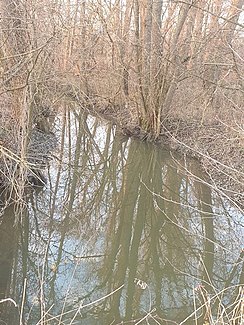
The Schönbach is a creek in the urban area of Prichsenstadt in the Lower Franconian district of Kitzingen flowing approximately west-northwest, which, after its origins in the Steigerwald and a more than 8 km long run on the eastern edge of the parish village of Stadelschwarzach, flows into the Schwarzach from the left .
geography
course
The brook arises approx. 3 km east of Altenschönbach in the western edge of the Steigerwald at an altitude of 411 m above sea level. NHN at the north foot of the 478 m above sea level. NHN high deer hill . Only about 400 meters further south rises the Reiche Ebrach on the flatter southeast slope of the mountain ridge in a higher position .
A little below its source, the brook turns to the left in its steady west-north-westerly direction and emerges from the Steigerwald natural area into the Steigerwald foothills , leaving the forest area around its source after a little over two kilometers. Then the stream crosses the church village Altenschönbach . Shortly before the Lochmühle , the stream is reinforced by the goose ditch that tapers from the right at an acute angle . After a few ponds on both sides of the course, the Marbach, coming from the east, joins the Schönbach at the southern edge of the Erlasgraben forest area .
After two more ponds on the bank, the stream crosses under the B 286 and the St 2420 one after the other . Between fields on the flat hills on the right and in the Gewann clay pit on the left, the stream meanders in a westerly direction to the floodplain of the Schwarzbach.
The Schönbach flows out on the eastern edge of Stadelschwarzach next to the route of the disused Kitzingen – Schweinfurt railway at an altitude of 223 m above sea level. NHN from the left into the Schwarzach . Its approximately 8.5 km long run ends 188 meters below its source, so it has a mean bed gradient of 22 ‰.
Catchment area
The catchment area of the Schönbach, which drains via the Schwarzach, the Main and the Rhine to the North Sea, covers 16.42 km². The source area is located in the Steigerwald , the remaining portion in the western subsequent Steigerwald foothills .
In turn, the catchment areas of the following neighboring waters are adjacent:
- On the north side, the Neudorfer Graben drains roughly parallel to the west and somewhat above the Schönbach to the Schwarzach , in the east the Breitbach continues upwards;
- in the east-northeast lies the headwaters of the Middle Ebrach in the Steigerwald , in the east-southeast that of the Reichen Ebrach , both run through the mountains in the opposite direction and drain, the first over the Rauhe Ebrach , the second directly into the Regnitz ;
- on the south side the Altbach flows almost in the direction of the Schönbach and a little downwards from this again into the Schwarzach.
Tributaries
| Surname | location | length
Main line |
muzzle | Muzzle
height |
|---|---|---|---|---|
| Goose pit | right | 2.61 | between Altenschönbach
and the hole mill |
262 |
| Marbach | Left | 7.27 | north of Prichsenstadt | 238 |
Places on the Schönbach
Locations on the run with their affiliations.
- City of Prichsenstadt
- Altenschönbach (Kirchdorf)
- Lochmühle (wasteland, right)
- Stadelschwarzach (parish village)
See also
Individual evidence
BayernAtlas ("BA")
Official online waterway map with a suitable section and the layers used here: Course and catchment area of the Schönbach
General introduction without default settings and layers: BayernAtlas of the Bavarian State Government ( notes )
Water directory Bavaria ("GV")
- ↑ Length according to: Directory of stream and river areas in Bavaria - Main river area, page 58 of the Bavarian State Office for the Environment, as of 2016 (PDF; 3.3 MB) (number of pages may change.)
- ↑ Catchment area according to: Directory of brook and river areas in Bavaria - Main river area, page 58 of the Bavarian State Office for the Environment, as of 2016 (PDF; 3.3 MB) (number of pages may change.)
